
An estuary is a partially enclosed coastal body of brackish water with one or more rivers or streams flowing into it, and with a free connection to the open sea. Estuaries form a transition zone between river environments and maritime environments and are an example of an ecotone. Estuaries are subject both to marine influences such as tides, waves, and the influx of saline water, and to fluvial influences such as flows of freshwater and sediment. The mixing of seawater and freshwater provides high levels of nutrients both in the water column and in sediment, making estuaries among the most productive natural habitats in the world.

The River Derwent, also known as timtumili minanya in palawa kani, is a significant river and tidal estuary in Tasmania, Australia. It begins its journey as a freshwater river in the Central Highlands at Lake St Clair, descending over 700 metres (2,300 ft) across a distance of more than 200 kilometres (120 mi). At the settlement of New Norfolk in the Derwent Valley its waters become brackish, flowing through Hobart, the capital city of Tasmania, its seawater estuary eventually empties into Storm Bay and the Tasman Sea.

Midway Point is a residential locality in the local government area (LGA) of Sorell in the South-east LGA region of Tasmania. The locality is about 5 kilometres (3.1 mi) south-west of the town of Sorell. The 2016 census recorded a population of 2859 for the state suburb of Midway Point. It is located on a small peninsula with Orielton Lagoon on its eastern side and Pittwater on its southern and western sides. The suburb meets the mid-way point of the Sorell Causeway from Hobart to Sorell, hence the name. Mcgees Bridge is connected to Midway Point on the Pittwater side. The suburb lies close to Hobart International Airport and is approximately 21 km to Hobart via the Tasman Highway. In recent years Midway Point has become a popular commuter town for people working in Hobart.

A Ramsar site is a wetland site designated to be of international importance under the Ramsar Convention, also known as "The Convention on Wetlands", an international environmental treaty signed on 2 February 1971 in Ramsar, Iran, under the auspices of UNESCO. It came into force on 21 December 1975, when it was ratified by a sufficient number of nations. It provides for national action and international cooperation regarding the conservation of wetlands, and wise sustainable use of their resources. Ramsar treaty participants meet regularly to identify and agree to protect "Wetlands of International Importance", especially those providing waterfowl habitat.

The Severn Estuary is the estuary of the River Severn, flowing into the Bristol Channel between South West England and South Wales. Its very high tidal range, approximately 50 feet (15 m), creates valuable intertidal habitats and has led to the area being at the centre of discussions in the UK regarding renewable tidal energy.
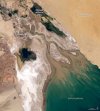
The Colorado River Delta is the region where the Colorado River once flowed into the Gulf of California in eastern Mexicali Municipality in the north of the state of Baja California, in northwestern Mexico. The delta is part of a larger geologic region called the Salton Trough. Historically, the interaction of the river's flow and the ocean's tide created a dynamic environment, supporting freshwater, brackish, and saltwater species. Within the delta region, the river split into multiple braided channels and formed a complex estuary and terrestrial ecosystems. The use of water upstream and the accompanying reduction of freshwater flow has resulted in the loss of most of the wetlands of the area, as well as drastic changes to the aquatic ecosystems - an ecosystem collapse.
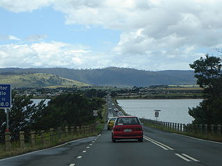
The Sorell Causeway is a causeway that carries the Tasman Highway across Pitt Water-Orielton Lagoon, from the western side of Midway Point to Sorell in the south-east of Tasmania, Australia. The causeway and adjacent McGees Bridge provide vital links between Hobart and two of Tasmania's principal tourist attractions - Port Arthur Historic Site on the Tasman Peninsula and the picturesque East Coast via the Tasman Highway.
The Orielton Lagoon is a shallow dystrophic lagoon located west of Sorell in south east Tasmania, Australia.

Guaraqueçaba Environmental Protection Area is a protected area in the State of Paraná, Brazil. It includes Atlantic Forest, mangrove, salt marsh and estuarine environments in an area with a relatively low human population.

Australia has coastal areas where mangrove thickets and swamps occur, such as in the intertidal zones of protected tropical, subtropical and some temperate coastal rivers, river deltas, estuaries, lagoons and bays. Less than 1% of Australia's total forested area consists of mangroves.

Moulting Lagoon Important Bird Area is a composite wetland site in eastern Tasmania, Australia. It comprises two adjacent and hydrologically continuous wetlands – Moulting Lagoon and the Apsley Marshes – at the head of Great Oyster Bay, near the base of the Freycinet Peninsula, between the towns of Swansea and Bicheno. Both components of the site are listed separately under the Ramsar Convention as wetlands of international significance. Moulting Lagoon is so named because it is a traditional moulting place for black swans. It is an important site for waterbirds.

The South Arm Important Bird Area is a disjunct tract of mainly intertidal land on the eastern outskirts of Hobart, Tasmania, Australia.
Jubho Lagoon is a large shallow brackish lagoon located in Sindh, Pakistan. In May 2011 Jubhoo lagoon was inducted into the list of Ramsar sites, consisting of wetlands of international importance.
The Bathurst Channel is a narrow offshore stretch of water that links Port Davey with Bathurst Harbour in the South West region of Tasmania, Australia. The Bathurst Channel is contained within the Port Davey/Bathurst Harbour Marine Nature Reserve, and the Southwest National Park, part of the Tasmanian Wilderness World Heritage Area.
Smiths Lake, an intermittently closed youthful saline coastal lagoon, is located within the Mid-Coast Council local government area in the Mid North Coast region of New South Wales, Australia. Smiths Lake is located adjacent to the village of Smiths Lake, and adjacent to the east coast, about 274 kilometres (170 mi) north of Sydney.

Little Waterhouse Lake is a freshwater coastal lagoon in the Waterhouse Conservation Area of north-eastern Tasmania, Australia. In 1982 it was designated a wetland of international importance under the Ramsar Convention.

Lough Furnace is a tidally-influenced, meromictic, saline lagoon in County Mayo, Ireland, located south of Lough Feeagh. It receives freshwater inflow from the upstream Lough Feeagh at the base of the Burrishoole Catchment and tidal input of saline water from Clew Bay, through the Burrishoole Estuary.
Estuaries of Australia are features of the Australian coastline. They are linked to tides, river mouths and coastal features and conditions. In many cases the features of estuaries are also named inlets.

Coal River is a river in southern Tasmania. With headwaters near Tunnack, it flows through the Coal River Valley and the town of Richmond, and empties into Pitt Water. In Richmond, the river is crossed by the historically significant Richmond Bridge, the oldest bridge built in Australia that is still in use.
The Bot River Estuary, also known as the Bot River Lagoon, is part of the Bot-Kleinmond Estuarine System in the Overberg region on the Western Cape of South Africa. It became a Ramsar site wetland in 2017. It is within the Kogelberg Biosphere Reserve.

