
Riverdale is a city in Scott County, Iowa, United States. The population was 405 at the 2010 census.
Pleasant Valley may refer to:

Richmond Valley is the name of a neighborhood located on the South Shore of Staten Island, one of the five boroughs of New York City, the largest city in the United States. Richmond Valley is bordered on the north by Pleasant Plains, to the south by Tottenville, to the west by the Arthur Kill, and to the east by the Lower New York Bay.

Neighborhoods in Washington, D.C., are distinguished by their history, culture, architecture, demographics, and geography. The names of 131 neighborhoods are unofficially defined by the D.C. Office of Planning. Neighborhoods can be defined by the boundaries of historic districts, Advisory Neighborhood Commissions, civic associations, and business improvement districts (BIDs); these boundaries will overlap.
Rockridge is a residential neighborhood and commercial district in Oakland, California. Rockridge is generally defined as the area east of Telegraph Avenue, south of the Berkeley city limits, west of the Oakland hills and north of the intersection of Pleasant Valley Avenue/51st Street and Broadway. Rockridge was listed by Money Magazine in 2002 as one of the "best places to live".

Downtown Portland, the city center of Portland, Oregon, United States, is located on the west bank of the Willamette River. It is in the northeastern corner of the southwest section of the city and where most of the city's high-rise buildings are found.

Perry South is a neighborhood on Pittsburgh, Pennsylvania's North Side.

This is a list of official neighborhoods in Louisville, Kentucky. Like many older American cities, Louisville has well-defined neighborhoods, many with well over a century of history as a neighborhood.
Pleasant Valley is a neighborhood that is among the older western neighborhoods of the city of Little Rock, Arkansas. The area is to the northwest of Breckenridge and west of Colony West. Pleasant Valley lies to the south of the hillier Pleasant Ridge and Walton Heights areas, and mostly to the east of St. Charles.
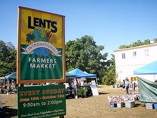
The Lents neighborhood in the Southeast section of Portland, Oregon is bordered by SE Powell Blvd. on the north, the Clackamas County line or City of Portland line on the south, SE 82nd Ave. to the west, and roughly SE 112th on the east. The NE corner overlaps with the Powellhurst-Gilbert neighborhood. In addition to Powellhurst-Gilbert on the north and east, Lents also borders Foster-Powell, Mt. Scott-Arleta, and Brentwood-Darlington on the west and Pleasant Valley on the east.

The Mt. Scott-Arleta neighborhood of Portland, Oregon is located in the city's southeast quadrant. It is bounded on the north by SE Foster Road, west by SE 60th Avenue, east by SE 82nd Avenue, and south by SE Duke. Mt. Scott-Arleta borders the neighborhoods of Woodstock on the west, Foster-Powell on the north, Lents on the east, and Brentwood-Darlington on the south.

Powellhurst-Gilbert is a neighborhood in the Southeast section of Portland, Oregon. It borders the neighborhoods of Montavilla, Hazelwood, and Mill Park on the north, Centennial on the east, Pleasant Valley on the east and south, and Lents and South Tabor on the west.

State Route 609 in Fairfax County, Virginia is a secondary state highway which traverses western portion of the county. The road is also known as Pleasant Valley Road.
Staten Island Community Board 3 is a local government unit of the city of New York, encompassing the Staten Island neighborhoods of Annadale, Arden Heights, Bay Terrace, Charleston, Eltingville, Great Kills, Greenridge, Huguenot, Pleasant Plains, Prince's Bay, Richmond Valley, Rossville, Tottenville and Woodrow.

Mount Pleasant is a working-class residential neighborhood situated in the northwest of the city of Providence, Rhode Island. It is bordered by Olneyville to the south, Valley to the east, Manton to the west, and Elmhurst to the northeast, and the Town of North Providence to the north. The major street boundaries that define Mount Pleasant are Academy Avenue to the east, Smith Street to the northeast, Atwells Avenue to the south, and portions of Bullock, Chalkstone, Mera, and Rushmore Avenues to the west.
East Riverside-Oltorf is a sprawling community located in Austin, Texas. It is located southeast of city's urban core.
Portland, Maine is home to many neighborhoods.

Pleasant Valley is an unincorporated community in Baker County, Oregon, United States. It is about 13 miles (21 km) southeast of Baker City on U.S. Route 30, slightly bypassed by Interstate 84.

