
The Himalayas, or Himalaya, are a mountain range in Asia separating the plains of the Indian subcontinent from the Tibetan Plateau. The range has some of the planet's highest peaks, including the highest, Mount Everest. Over 100 peaks exceeding 7,200 m (23,600 ft) in elevation lie in the Himalayas. By contrast, the highest peak outside Asia is 6,961 m (22,838 ft) tall.

Porter County is a county in the U.S. state of Indiana. As of 2020, the population was 173,215, making it the 10th most populous county in Indiana. The county seat is Valparaiso. The county is part of Northwest Indiana, as well as the Chicago metropolitan area. Porter County is the site of much of the Indiana Dunes, an area of ecological significance. The Hour Glass Museum in Ogden Dunes documents the region's ecological significance.

Indian Lake is a town in Hamilton County, New York, United States. The population was 1,352 at the 2010 census. The name is from a lake of the same name that is largely inside the town. There are no permanent stop lights in the town. Law enforcement is provided by New York State Troopers and Hamilton County Sheriff's Office.
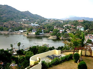
Mount Abu is a hill station in the Aravalli Range in Pindwara - Abu Assembly Constituency Of Sirohi district of Rajasthan state in western India, near the border with Gujarat. The mountain forms a rocky plateau 22 km long by 9 km wide. The highest peak on the mountain is Guru Shikhar at 1,722 m (5,650 ft) above sea level. It is referred to as 'an oasis in the desert' as its heights are home to rivers, lakes, waterfalls and evergreen forests. The nearest train station is Abu Road railway station: 28 km away.

Cascade Mountain is in Essex County of New York. It is one of the 46 Adirondack High Peaks (36th) and is located in the Adirondack Park. Its name comes from a series of waterfalls on a brook near the mountain's base. The lake it flows into and the pass between Cascade and Pitchoff mountains are also named Cascade.
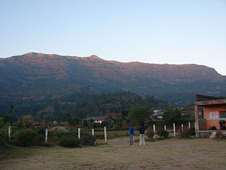
Kalsubai is a mountain in the Western Ghats, located in the Indian state of Maharashtra. Its summit, situated at an elevation of 1,646 metres (5,400 ft), is the highest point in Maharashtra.
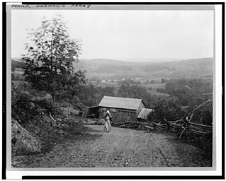
Dingmans Ferry is an unincorporated community in Delaware Township, Pike County, Pennsylvania, United States. As of 2014, it had a population of 7,477 people. It was originally sited on the Delaware River, in an area now included in the Delaware Water Gap National Recreation Area. When the Corps of Engineers acquired the land by eminent domain in the mid-twentieth century for the creation of the proposed Tocks Island Dam project, it relocated the community further up the hill.
The Franklin Lakes Public Schools are a community public school district serving students in pre-kindergarten through eighth grade from Franklin Lakes, in Bergen County, New Jersey, United States.

The West Canada Lake Wilderness Area is an Adirondack Park Forest Preserve management unit in the State of New York, USA.
Indian Mountain State Park is a state park in Campbell County, Tennessee, in the southeastern United States. Established in 1971, the park consists of 213 acres (0.86 km2) situated at the base of Indian Mountain, a 1,949-foot (594 m) summit that overlooks the Elk Valley in the Cumberland Mountains. The park is located immediately west of the city of Jellico, and the history and development of the two are intertwined to a great extent.
Turtle Mountain Indian Reservation is a reservation located in northern North Dakota, United States. It is the land base for the Turtle Mountain Band of Chippewa Indians. The population of the Turtle Mountain Indian Reservation consists of Plains Ojibwe and Métis peoples; the reservation was established in 1882.

Sirumalai is a region of 60,000 acres (200 km2) situated 25 km (16 mi) from Dindigul, 90 km (56 mi) from Madurai, and 125 km from Trichy, Tamil Nadu, India. There are many high hills in the area. Sirumalai range is the last mountain range of the Eastern Ghats. The last mountains of the Sirumalai mountain range are the Azhagar Kovil Hills which are present in Madurai District. Azhagar Kovil Hills are the most important place of worship for the Hindu religion. Tracking is allowed in the Azhagar Kovil Hills. The nearest Eastern Ghats hills to Sirumalai Hills are the Narthamalai Hills.
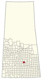
The Rural Municipality of Last Mountain Valley No. 250 is a rural municipality (RM) in the Canadian province of Saskatchewan within Census Division No. 11 and SARM Division No. 5.

The Albion Mountains are a mountain range in the U.S. states of Idaho (~99%) and Utah (~1%), spanning Cassia County, Idaho and barely reaching into Box Elder County, Utah. The highest point in the range is Cache Peak at 10,339 feet (3,151 m), and the range is a part of the Great Basin Divide and the Basin and Range Province. Most of the mountains are part of the Albion Division of the Minidoka Ranger District of Sawtooth National Forest.

Carry the Kettle Nakoda Nation is a Nakota (Assiniboine) First Nation located about 80 km (50 mi) east of Regina, Saskatchewan and 13 km (8.1 mi) south of Sintaluta. The reservation is in Treaty 4 territory.

Northeast India consists of the eight states Arunachal Pradesh, Assam, Manipur, Meghalaya, Mizoram, Nagaland, Sikkim and Tripura. Tourism in this area is based around the unique Himalayan landscape and culture distinct from the rest of India.

Dzuluk or Zuluk or Jhuluk or Jaluk is a small hamlet located at a height of 9,400 feet (2,900 m) on the rugged terrain of the lower Himalayas in Rongli Subdivision of Pakyong District, which lies in the Indian state Sikkim. This place is relatively an emerging and offbeat destination in East Sikkim. Today it is a tourist destination for the view of the eastern Himalayan mountain range including the Kanchenjunga.

Rum Hill is a mountain located in Central New York Region of New York northwest of the Hamlet of Pierstown. Red House Hill is located southeast, Metcalf Hill is located south, Allen Lake and Mohegan Hill are located north-northwest and Otsego Lake is located east of Rum Hill.

Bell Mountain is a mountain located in Adirondack Mountains of New York located in the Town of Indian Lake east of Indian Lake.

Moose Mountain Upland, Moose Mountain Uplands, or commonly Moose Mountain, is a hilly plateau located in the south-east corner of Saskatchewan, Canada that covers an area of about 13,000 square kilometres. The upland rises about 200 metres above the broad, flat prairie which is about 600 metres above sea level. The highest peak is "Moose Mountain" at 830 metres above sea level. The area was named Moose Mountain because of the large number of moose that lived in the area. When it was originally used by fur traders, Métis, and the Indigenous peoples, the plateau was called Montagne a la Bosse, which is French for "The Mountain of The Bump or Knob."

