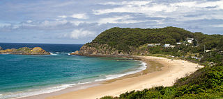
Potato Point is a village in the Eurobodalla Shire lying on the south coast of New South Wales, Australia. It is connected by road to the town of Bodalla, and surrounded by the Eurobodalla National Park. The Yuin are considered to be the traditional owners of the region. At the 2016 census, Potato Point had a population of 135 and 56 occupied and 78 unoccupied dwellings.[1] The only non-residential facilities are the local rural fire brigade depot which houses two appliances, toilet and shower block, boat ramp, two small parks and a telephone box.
Remains of a wharf jut into the sea over the rocks of the Point, which include wooden piers, thick iron staples and various carvings into the softer rock. Further around to the south are the rusting remains of an old boiler and other machinery.
The beaches on either side of the Point are Potato Beach (north) and Jemison's Beach (south). The latter is open to rough seas and wild winds, whereas the former is more sheltered and known locally for good surfing breaks and fine beach fishing, especially of salmon and bream. Cod, eels and luderick are taken from the rocks of the Point. Notable diving locations are found offshore from the Point, which can be accessed from the local north-facing boat ramp.
To the north lies the Beachcomber Holiday Park and Lake Brunderee. This small tidal lake is connected intermittently to the ocean by Potato Creek, and is a major habitat for swans and chestnut teal, as well as an important drought refuge. In 1999 the lake was declared a habitat protection zone due to its importance as a fish spawning ground.[2] To the south lies a small shallow, and often dry unnamed coastal lake which abounds in bird-life at various times of the year. Horse trails snake through the hinterland. Local fauna includes eastern grey kangaroos, red-necked wallabies, bandicoots, emus, echidnas, eastern rosellas, crimson rosellas and sea eagles.
Lord Howe Island Marine Park is the site of Australia's and the world's most southern coral reef ecosystem. The island is 10 km in length, 2 km wide and consists of a large lagoonal reef system along its leeward side, with 28 small islets along its coast. In 1999, the waters within three nautical miles of Lord Howe Island (465.45 km2) were declared a marine park under the NSW Marine Park Act 1997 to protect its unique marine biodiversity, with the park currently being managed by the New South Wales Marine Parks Authority. Both Lord Howe Island and Balls Pyramid are incorporated within the three nautical miles protected by the state marine park. Both marine parks complement the island's status as a World Heritage Site.
Western Port, commonly but unofficially known as Western Port Bay, is a large tidal bay in southern Victoria, Australia, opening into Bass Strait. It is the second largest bay in the state. Geographically, it is dominated by two large islands; French Island and Phillip Island. At the time it was renamed, its position was west of other known ports and bays, but Western Port has become something of a misnomer as it lies just to the east of the larger Port Phillip and the city of Melbourne. It is visited by Australian fur seals, whales and dolphins, as well as many migratory waders and seabirds. It is listed under the Ramsar Convention as a wetland of international significance.
Eurobodalla Shire is a local government area located in the South Coast region of New South Wales, Australia. The Shire is located in a largely mountainous coastal region and situated adjacent to the Tasman Sea, the Princes Highway and the Kings Highway.
Port Stephens, an open youthful tide-dominated drowned-valley estuary, is a large natural harbour of approximately 134 square kilometres (52 sq mi) located in the Hunter Region of New South Wales, Australia.
The Tweed River is a river situated in the Northern Rivers district of New South Wales, Australia. From the middle reaches of its course, the state boundary between New South Wales and Queensland is located approximately 10 kilometres (6.2 mi) north.
Inverloch is a seaside town located in Victoria, Australia and the most populous city of the Bass Coast Shire. It is located 143 kilometres (89 mi) south east of Melbourne via the South Gippsland Highway on the Bass Highway in the Bass Coast Shire of Gippsland, Victoria, Australia. Known originally for the calm waters of Anderson Inlet, it is now also known for the discovery of Australia's first dinosaur bone.
Malua Bay is a locality in the South Coast region of the state of New South Wales, Australia. It is situated in the Eurobodalla Shire. At the 2016 census, Malua Bay had a population of 1,929.
Narooma is a town in the Australian state of New South Wales on the far south coast. The town is on the Princes Highway, which crosses the Wagonga Inlet to North Narooma. The heritage town of Central Tilba is nearby to the south.
Rosedale is a beachside settlement in New South Wales, Australia. It is on the south coast, about 18 kilometres by road south of Batemans Bay. The area is administered by the Eurobodalla Shire. At the 2016 census, Rosedale had a population of 221.
Seal Rocks is a small coastal settlement in the Mid-Coast Council local government area, in the Mid North Coast region of New South Wales, Australia, 275 kilometres (171 mi) north-north-east of Sydney. It is famous for its many premier surfing beaches, and also for being the home of Seal Rocks lighthouse, officially known as Sugarloaf Point Lighthouse. At the 2021 census, the area had a population of 56 persons.
Sea Island is an island in the Fraser River estuary in the city of Richmond, British Columbia. It is located south of the city of Vancouver and north and west of Lulu Island. Sea Island is the home to Vancouver International Airport (YVR), a nature conservation area, and a permanent resident population of 814, most of which live in the neighbourhood of Burkeville. A small part of the island is under the administration of the Musqueam Indian Band.
Tuross Head is a seaside village on the south coast of New South Wales, Australia. It is approximately halfway between the townships of Moruya and Narooma, a few kilometres off the Princes Highway. As of the 2016 census, Tuross Head has a population of 2,241 people.
Dalmeny is a town on the south coast of New South Wales, Australia, approximately seven kilometres north of Narooma. At the 2016 census, Dalmeny had a population of 1,937 people.
Kianga is a small town on the South Coast of New South Wales, Australia, immediately north of the town of Narooma. The town contains few facilities and thus relies on nearby Dalmeny and Narooma. At the 2011 census, Kianga had a population of 738.
South Durras is a small village on the South Coast of New South Wales, Australia. South Durras is located approximately 280 kilometres south of Sydney and 15 kilometres north of Batemans Bay, in the local government area of Eurobodalla Shire. The village is surrounded by the Murramarang National Park.
Smiths Lake is a small village in the Mid North Coast region of Pacific Palms, located within the Mid-Coast Council local government area of New South Wales, Australia. Smiths Lake is approximately 274 kilometres (170 mi) north of Sydney. Smiths Lake gives its name to the village, situated nearby. At the 2016 census, Smiths Lake had a population of 1,235 people.
Cape Rodney-Okakari Point Marine Reserve is a 5.5 km2 (2.1 sq mi) protected area in the North Island of New Zealand.
Cape Byron Marine Park is one of four marine parks in New South Wales, Australia, and is the most recently sanctioned. The Cape Byron Marine Park is located in Northern NSW and extends 37 kilometres (23 mi) from the Brunswick River to Lennox Head. The marine park extends out to 3 nautical miles which dictates the border between state and federal jurisdiction. The marine park covers an area of 220 square kilometres (85 sq mi) and includes a variety of marine terrain including beaches, rocky shores, open ocean and the tidal waters of the Brunswick River and its tributaries, the Belongil Creek and Tallow Creek. The Cape Byron Marine Park was declared in 2002 and the zoning plan was implemented in April 2006. Of the 15 distinct marine ecosystems identified within the Tweed-Moreton bioregion, the Cape Byron Marine Park supports 10 of these.
Congo is a village in Eurobodalla Shire on the South Coast of New South Wales. Congo is located 315 km south of Sydney, and 10 km south of Moruya.
Solitary Islands Marine Park (SIMP) is a marine park in New South Wales State waters, Australia. It adjoins the Solitary Islands Marine Reserve and was declared under the Marine Parks Act 1997 (NSW) in January 1998. Prior to this it was declared a marine reserve in 1991. The Park was one of the first declared in NSW and stretches along the northern NSW coast, from Muttonbird Island, Coffs Harbour, to Plover Island near Sandon River, 75 kilometres to the north. It includes coastal estuaries and lakes and extends from the mean high water mark, to three nautical miles out to sea, covering an area of around 72 000 hectares. There are five main islands in the Park, North Solitary Island, North West Solitary Island, South West Solitary Island, South Solitary Island and Split Solitary Island, as well as other significant outcrops such as Muttonbird Island and submerged reefs.
This page is based on this Wikipedia article Text is available under the CC BY-SA 4.0 license; additional terms may apply. Images, videos and audio are available under their respective licenses.