Lake Michigan is one of the five Great Lakes of North America and the only one located entirely within the United States. The other four Great Lakes are shared by the U.S. and Canada. It is the second-largest of the Great Lakes by volume and the third-largest by surface area, after Lake Superior and Lake Huron. To the east, its basin is conjoined with that of Lake Huron through the wide Straits of Mackinac, giving it the same surface elevation as its easterly counterpart; the two are technically a single lake.

Wood County is a county located in the U.S. state of Wisconsin. As of the 2010 census, the population was 74,749. Its county seat is Wisconsin Rapids. The county is named after Joseph Wood, a member of the Wisconsin State Assembly.

Sawyer County is a county in the U.S. state of Wisconsin. As of the 2010 census, the population was 16,557. Its county seat is Hayward.

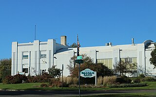
Burnett County is a county located in the U.S. state of Wisconsin. As of the 2010 census, the population was 15,457. Its county seat is Siren, with the majority of county governmental services located at the Burnett County Government Center. The county was created in 1856 and organized in 1865.
Sand Lake is a town in Burnett County in the U.S. state of Wisconsin. The population was 531 at the 2010 census.

The Wisconsin Glacial Episode, also called the Wisconsinan glaciation, was the most recent glacial period of the North American ice sheet complex. This advance included the Cordilleran Ice Sheet, which nucleated in the northern North American Cordillera; the Innuitian ice sheet, which extended across the Canadian Arctic Archipelago; the Greenland ice sheet; and the massive Laurentide ice sheet, which covered the high latitudes of central and eastern North America. This advance was synchronous with global glaciation during the last glacial period, including the North American alpine glacier advance, known as the Pinedale glaciation. The Wisconsin glaciation extended from approximately 75,000 to 11,000 years ago, between the Sangamon interglacial and the current interglacial, the Holocene. The maximum ice extent occurred approximately 25,000–21,000 years ago during the last glacial maximum, also known as the Late Wisconsin in North America.
Glacial Lake Wisconsin was a prehistoric proglacial lake that existed from approximately 18,000 to 14,000 years ago, at the end of the last ice age, in the central part of present-day Wisconsin in the United States.

There are several historic lighthouses on Lake Superior on or near the Apostle Islands in Wisconsin. Six of these lighthouses, all in the Apostle Islands National Lakeshore, were listed as a group on the National Register of Historic Places in 1977 under the name Apostle Islands Lighthouses.
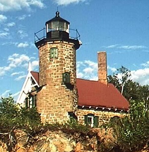
The Sand Island Light is a lighthouse located on the northern tip of Sand Island, one of the Apostle Islands, in Lake Superior in Bayfield County, Wisconsin, near the city of Bayfield.

The Wisconsin Point Light is a lighthouse located near Superior, on Wisconsin Point, in Douglas County, Wisconsin, United States.
The Wisconsin Northern Railroad is the trade name employed by Progressive Rail Inc. to operate 62.3 miles (100.3 km) of railroad in northern Wisconsin and began operations on November 29, 2004.

Whitefish Dunes State Park is a 867-acre (351 ha) state park of Wisconsin, United States, on the eastern shore of the Door Peninsula. This day-use park preserves the most substantial sand dunes on the western shore of Lake Michigan. The remains of eight successive prehistoric Native American villages are on the National Register of Historic Places as Whitefish Dunes-Bay View Site.

The St. Croix Chippewa Indians of Wisconsin are a Federally recognized Indian Tribe, located in northwestern Wisconsin, along the St. Croix River valley and watershed.

Stone Lake is an unincorporated census-designated place in Sawyer and Washburn counties, Wisconsin, United States. Stone Lake is located on the eastern shore of Stone Lake and along Wisconsin Highway 70, 12 miles (19 km) west-northwest of Couderay. The Sawyer County portion of the community is located in the town of Sand Lake, while the Washburn County portion is located in the town of Stone Lake. As of the 2010 census, its population is 178.
Sand Bay is an unincorporated community in the town of Russell, Bayfield County, Wisconsin, United States. The community is located within the Red Cliff Indian Reservation.
Hauer is an unincorporated community located in the town of Sand Lake, Sawyer County, Wisconsin, United States.

Sevona was a steel hulled lake freighter that sank in Lake Superior off the coast of Sand Island in Bayfield County, Wisconsin, United States. The wreckage site was added to the National Register of Historic Places in 1993.
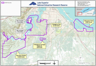
The Lake Superior National Estuarine Research Reserve is located along the St. Louis River in Douglas County, the northwest corner of Wisconsin, United States. It is one of many National Estuarine Research Reserves. It has an area of 16,697 acres (6,757 ha), and was designated in 2010.