Sedgefield, South Africa

Last updated
Sedgefield
South Africa Western Cape location map.svg
Red pog.svg
Sedgefield
South Africa adm location map.svg
Red pog.svg
Sedgefield
Coordinates: 34°01′17″S22°48′12″E / 34.02139°S 22.80333°E / -34.02139; 22.80333
Country South Africa
Province Western Cape
District Garden Route
Municipality Knysna
Area
[1]
  Total7.85 km2 (3.03 sq mi)
Population
 (2011) [1]
  Total8,286
  Density1,100/km2 (2,700/sq mi)
Racial makeup (2011)
[1]
   Black African 24.8%
   Coloured 29.5%
   Indian/Asian 0.3%
   White 42.8%
  Other2.6%
First languages (2011)
[1]
   Afrikaans 48.8%
   English 26.7%
   Xhosa 18.2%
   Sotho 1.2%
  Other5.1%
Time zone UTC+2 (SAST)
Postal code (street)
6573
PO box
6573
Area code 044

Sedgefield is a coastal town on the Garden Route in the Western Cape province of South Africa. It is situated on the N2 national road, between George and Knysna.

Contents

The town was proclaimed in 1929 on the farm Sedgefield, which in turn was named in 1894 after the village of the same name in the UK where the father (Henry Barrington) of the then farm owner was born.

History

The farm Ruigtevlei was granted to the widow Meeding by Lord Charles Somerset and upon her death in 1878, the farm was divided into 9 lots. Lots A and B were first bought by individual farmers, before eventually being purchased in 1894 by John Barrington, son of then-famous politician, farmer and industrialist Henry Barrington (referred to as ‘Henry Barrington of Portland’ in the novel ‘Circles in a forest’ by Dalene Matthee). John named the town in honour of his father's birthplace Sedgefield in the United Kingdom.

Kate Maurice (née Barrington) inherited the farm Sedgefield from her brother upon his death in 1901. Kate sold the farm in 1911 to Salmon Terblans. A part of the farm Sedgefield was subsequently sold as Middelplaas, but was reincorporated in 1926. Terblans and Thomas Moodie investigated the possibility of proclaiming a town on the farm. Eventually, Moodie invested a lot of work into developing a town plan after securing an option to buy the farm but due to an oversight by Moodie's lawyer, Terblans was able to step back out of their agreement at the last moment and sell the ground to Thesen and Company. However, Charlie Thesen decided to compensate Moodie for his invested effort and allowed him to name the newly proclaimed town.

The name of Sedgefield was but one of a number of names considered by Moodie. In the end, the fact that it translated well to the original Afrikaans name of Ruigtevlei as well as the observation that it was very descriptive of the environment gave sway in favour of the name.

After proclamation, the town experienced organic growth by attracting families who were attracted by the ‘new winter resort’ advertised in the George and Knysna Herald from 1927 onwards. The first families to settle were the Salts, Schumachers, Browns, Barnards and Mullers. In 1921 a railway connection between George and Knysna was planned and the project was completed in 1928 by routing the line over a new bridge crossing the adjacent Swartvlei (‘Black lake’). In 1940, the town was given a postal service outlet and in 1947 the road through Sedgefield was completed, thus fully integrating the town into the commercial route between George and Knysna.

A library was opened in 1962 and the town expanded further during the next four decades to comprise a central business district with supermarkets, pharmacies, filling stations, curio shops and other undertakings. Fresh water has been supplied from nearby Karatara River Municipal water extraction plant run by Sedgefield Municipality then Knysna Municipality, but being pressed by an unusually dry summer a desalination plant was erected in 2009 to make the town totally self-sufficient in terms of water supply.

Until the end of the 20th century, Sedgefield was an independent local authority. When the ANC came to power nationally, for a variety of reasons, they decided to reduce the total of such local authorities country-wide and Sedgefield became part of Knysna. This was a decision that was opposed by many of the residents.
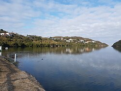
Sedgefield today

The central area of Sedgefield (The Village) together with the Island (Extension 1) form part of the original town area. Since then, the extensions of Smutsville, Sizamile, Meedingsride, Groenvallei, Myoli Beach and Cola Beach were added to provide residences for the approximately 15 000 permanent inhabitants of Sedgefield.

The town's main economic activity revolves around tourism, with secondary activities centered on serving the needs of local residents and regional farmers. The laid-back rustic village atmosphere is reflected in the town's motto of being a place where ‘the tortoise sets the pace’. Sedgefield was the first African member of the Cittaslow movement. A popular attraction is the Wild-Oats Mosaic & Scarab Markets which attract large numbers of tourists and residents from the region, and further afield, every Saturday morning with fresh produce, local crafts & tasty homemade foods to suit everyone. A golf course (the ‘Fynbos Links’), tennis court and bowls field caters to the significant portion of retired permanent residents of the town.

Local natural attractions include Gericke's lookout point which resembles the profile of a resting lion and the protected natural dune areas which harbours Cape Fynbos plantations and rare bird species.

Notable people

Related Research Articles

<span class="mw-page-title-main">Sedgefield</span> Town and civil parish in County Durham, England

Sedgefield is a market town and civil parish in County Durham, England. It had a population of 5,211 as at the 2011 census. It has the only operating racecourse in County Durham.

<span class="mw-page-title-main">Plettenberg Bay</span> Place in Western Cape, South Africa

Plettenberg Bay, nicknamed Plet or Plett, is the primary town of the Bitou Local Municipality in the Western Cape Province of South Africa. As of the census of 2001, there were 29,149 population. It was originally named Bahia Formosa by early Portuguese explorers and lies on South Africa's Garden Route 210 km from Port Elizabeth and about 600 km from Cape Town.

<span class="mw-page-title-main">Knysna</span> Town in Western Cape, South Africa

Knysna is a town with 76,150 inhabitants in the Western Cape province of South Africa. and is one of the destinations on the loosely defined Garden Route tourist route. It is situated 60 kilometres east of the city of George on the N2 highway, and 33 kilometres west of the Plettenberg Bay on the same road.

<span class="mw-page-title-main">Garden Route</span>

The Garden Route is a 300-kilometre (190 mi) stretch of the south-eastern coast of South Africa which extends from Witsand in the Western Cape to the border of Tsitsikamma Storms River in the Eastern Cape. The name comes from the verdant and ecologically diverse vegetation encountered here and the numerous estuaries and lakes dotted along the coast. It includes towns such as Witsand, Heidelberg, Riversdale, Stilbaai, Albertinia, Gouritsmond, Knysna, Plettenberg Bay, Mossel Bay, Oudtshoorn, Great Brak River, Little Brak River, Wilderness, Sedgefield and Nature's Valley; with George, the Garden Route's largest city and main administrative centre.

<span class="mw-page-title-main">Knysna Local Municipality</span> Local municipality in Western Cape, South Africa

Knysna Municipality is a local municipality within the Garden Route District Municipality, in the Western Cape province of South Africa. As of 2011, the population is 68,659. Its municipal code is WC048.

<span class="mw-page-title-main">George Local Municipality</span> Local municipality in Western Cape, South Africa

George Municipality is a local municipality within the Garden Route District Municipality, in the Western Cape province of South Africa. As of 2011, the population is 193,672. Its municipality code is WC044.

Places named Sedgefield include:

<span class="mw-page-title-main">George, South Africa</span> City in Western Cape, South Africa

George is the second largest city in the Western Cape province of South Africa. The city is a popular holiday and conference centre, as well as the administrative and commercial hub and the seat of the Garden Route District Municipality. It is named after the British Monarch George III.

Heidelberg is a town in the Western Cape, South Africa. It is located near South Africa's south coast, on the N2 highway, within the Hessequa region, 274 km east of Cape Town. Heidelberg marks the start of the Garden Route. Heidelberg is part of the Hessequa Local Municipality.

<span class="mw-page-title-main">Saasveld Forestry College</span>

Saasveld Forestry College is a South African college for the training of foresters, situated on the Garden Route in the Western Cape between George and Knysna. Before moving to its present location in 1932, it was located at Tokai, Cape Town.

<span class="mw-page-title-main">Garden Route National Park</span> Coastal national park in South Africa

The Garden Route National Park is a national park in the Garden Route region of the Western Cape and Eastern Cape provinces in South Africa. It is a coastal reserve well known for its indigenous forests, dramatic coastline, and the Otter Trail. It was established on 6 March 2009 by amalgamating the existing Tsitsikamma and Wilderness National Parks, the Knysna National Lake Area, and various other areas of state-owned land.

<span class="mw-page-title-main">Wilderness National Park</span> National park around the seaside town of Wilderness, Western Cape, South Africa

Wilderness National Park, also called the Wilderness Section, is located around the seaside town of Wilderness between the larger towns of George and Knysna, in the Western Cape. It is a protected area of South Africa forming part of the Garden Route National Park.

Christopher Harison was a British military officer and forestry official in South Africa. He served as Conservator of Forests and was an authority on forest practice in the region.

<span class="mw-page-title-main">Charles Wilhelm Thesen</span>

Charles Wilhelm Thesen was a Norwegian-born South African shipowner and timber merchant who played a leading role in the public affairs of the South African town of Knysna. He was actively involved in the timber and shipbuilding industry of the region, and acquired Paarden Island in the Knysna Lagoon, on which he built a sawmill and shipyard. The island was later renamed Thesen Island, after him and his family.

<span class="mw-page-title-main">Thomas Henry Duthie</span>

Captain Thomas Henry Duthie was a Scottish member of the 72nd Highlanders who arrived in Cape Town, South Africa in 1826 and was stationed at the Castle of Good Hope.

Thornham is a town in the local municipality of Kou-Kamma, in Sarah Baartman District Municipality in the Eastern Cape province of South Africa.

<span class="mw-page-title-main">Millwood, South Africa</span>

Millwood in South Africa was the site of a short-lived gold rush in the 1880s. Millwood Mining Village was located in the foothills of the Outeniqua Mountains near Knysna and had a population of a few hundred at the height of its small-scale mining activity which lasted only five years, largely due to the difficulty of following the vein in much-folded formations.

<span class="mw-page-title-main">Henry Barrington</span>

Henry Frederick Francis Adair Barrington, was a South African lawyer, farmer and member of Parliament.

<span class="mw-page-title-main">Knysna elephants</span> Group of African bush elephants

The Knysna elephants were the relicts of once substantial herds of African bush elephant in the Outeniqua/Tsitsikamma region of southernmost South Africa. As of 2022, the herds have been reduced to a lone adult female. The elephant herds roamed the southern tip of Africa into the 1800s and 1900s, when contact with European farmers and hunters led to their decimation. It is conjectured that about 1,000 elephants historically roamed the Outeniqua/Tsitsikamma area. A 2006 DNA analysis of dung samples revealed the presence of at least 5 cows and possibly some bulls and calves, moving within an area of 121,000 hectares of forest managed by SANParks – the only unfenced elephant group in South Africa. However, by 2019, researchers realised that a mature female at the Knysna Forest was the last to survive.

<span class="mw-page-title-main">Pledge Nature Reserve</span> Nature reserve in Knysna, South Africa

Pledge Nature Reserve is a registered public nature reserve located in the town of Knysna in the Garden Route district of the Western Cape province in southwestern South Africa. The reserve covers a relatively small area adjacent to the town center and is accessible from the main road on the N2 highway. The area which is now Pledge Nature Reserve has a long history of use by the townspeople and Knysna division of the Girl Guides South Africa, and the Brownie movement. However, the area was only established as a Local Nature Reserve in the Government Gazette of South Africa Notice 726 on 11 October 1991. The reserve is administered by a voluntary trust, the Pledge Nature Reserve Trust, and an appointed voluntary management committee, who were granted a 99-year lease by the Knysna Local Municipality.

References

  1. 1 2 3 4 "Main Place Sedgefield". Census 2011.