Simpson Desert Conservation Park

Last updated

Simpson Desert Conservation Park
South Australia

Rangers looking at Approdinna Attora Knolls in the Simpson Desert Conservation Park.JPG

Rangers looking at Approdinna Attora Knolls in the Simpson Desert Conservation Park
Australia South Australia relief location map.png
Red pog.svg
Simpson Desert Conservation Park
Nearest town or city Oodnadatta [1]
Coordinates 26°14′46″S137°52′23″E / 26.2461486829999°S 137.872967886°E / -26.2461486829999; 137.872967886 Coordinates: 26°14′46″S137°52′23″E / 26.2461486829999°S 137.872967886°E / -26.2461486829999; 137.872967886 [2]
Established 14 December 1967 [3]
Area 6,932.68 km2 (2,676.7 sq mi) [4]
Managing authorities Department of Environment and Water
Website Simpson Desert Conservation Park
See also Protected areas of South Australia

Simpson Desert Conservation Park (formerly Simpson Desert National Park) is a protected area located in the Australian state of South Australia about 970 kilometres (600 mi) north of the state capital of Adelaide and above 215 kilometres (134 mi) north-east of the town of Oodnadatta. [5] [1]

Protected area location which receives protection because of its recognised natural, ecological or cultural landscape values

Protected areas or conservation areas are locations which receive protection because of their recognized natural, ecological or cultural values. There are several kinds of protected areas, which vary by level of protection depending on the enabling laws of each country or the regulations of the international organizations involved.

South Australia State of Australia

South Australia is a state in the southern central part of Australia. It covers some of the most arid parts of the country. With a total land area of 983,482 square kilometres (379,725 sq mi), it is the fourth-largest of Australia's states and territories by area, and fifth largest by population. It has a total of 1.7 million people, and its population is the second most highly centralised in Australia, after Western Australia, with more than 77 percent of South Australians living in the capital, Adelaide, or its environs. Other population centres in the state are relatively small; Mount Gambier, the second largest centre, has a population of less than 30,000.

Adelaide city centre Suburb of Adelaide, South Australia

Adelaide city centre is the innermost locality of Greater Adelaide, the capital city of South Australia. It is known by locals simply as "The City" or "Town" to distinguish it from Greater Adelaide and from the City of Adelaide. The locality is split into two key geographical distinctions: the city "square mile", bordered by North, East, South and West Terraces; and the section of the parklands south of the River Torrens which separates the built up part of the city from the surrounding suburbs and North Adelaide.

Contents

The conservation park occupies land within the Simpson Desert in the gazetted locality of the same name. It is bounded by the borders of the Northern Territory and Queensland to its north and by the Simpson Desert Regional Reserve to its west, south and east. [5] [1]

Simpson Desert desert in Central Australia

The Simpson Desert is a large area of dry, red sandy plain and dunes in Northern Territory, South Australia and Queensland in central Australia. It is the fourth largest Australian desert, with an area of 176,500 km2 and is the world's largest sand dune desert.

Simpson Desert, South Australia Suburb of Pastoral Unincorporated Area , South Australia

Simpson Desert is a locality in the Australian state of South Australia located about 920 kilometres north of the capital city of Adelaide and which is located within the desert of the same name.

Northern Territory federal territory of Australia

The Northern Territory is an Australian territory in the central and central northern regions of Australia. It shares borders with Western Australia to the west, South Australia to the south, and Queensland to the east. To the north, the territory looks out to the Timor Sea, the Arafura Sea and the Gulf of Carpentaria, including Western New Guinea and other Indonesian islands. The NT covers 1,349,129 square kilometres (520,902 sq mi), making it the third-largest Australian federal division, and the 11th-largest country subdivision in the world. It is sparsely populated, with a population of only 246,700, making it the least-populous of Australia's eight states and major territories, with fewer than half as many people as Tasmania.

The land within the boundaries of the conservation park first obtained protected area status on 14 December 1967 as a national park proclaimed under the National Parks Act 1966. [3] [6] On 27 April 1972, the national park was reconstituted as the Simpson Desert Conservation Park upon the proclamation of the National Parks and Wildlife Act 1972 . [7] As of 2018, it covered an area of 6,932.68 square kilometres (2,676.72 sq mi). [4]

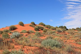
In combination with Simpson Desert Regional Reserve and Witjira National Park, it forms a protected area representing one of the world's best examples of dunal desert. A wide variety of desert flora and fauna are protected in a landscape of varied dune systems, extensive playa lakes, spinifex grasslands and Acacia woodlands. These trees soak up water from underground water springs.[ citation needed ]

Witjira National Park Protected area in South Australia

Witjira National Park is a protected area in the Australian state of South Australia about 987 kilometres north of the state capital of Adelaide.

Dune A hill of loose sand built by aeolian processes or the flow of water

In physical geography, a dune is a hill of loose sand built by aeolian processes (wind) or the flow of water. Dunes occur in different shapes and sizes, formed by interaction with the flow of air or water. Most kinds of dunes are longer on the stoss (upflow) side, where the sand is pushed up the dune, and have a shorter "slip face" in the lee side. The valley or trough between dunes is called a slack. A "dune field" or erg is an area covered by extensive dunes.

Desert Area of land where little precipitation occurs

A desert is a barren area of landscape where little precipitation occurs and, consequently, living conditions are hostile for plant and animal life. The lack of vegetation exposes the unprotected surface of the ground to the processes of denudation. About one-third of the land surface of the world is arid or semi-arid. This includes much of the polar regions where little precipitation occurs and which are sometimes called polar deserts or "cold deserts". Deserts can be classified by the amount of precipitation that falls, by the temperature that prevails, by the causes of desertification or by their geographical location.

In an unprecedented move, it and the Simpson Desert Regional Reserve were closed to public access by the state government from 1 December 2008 to 15 March 2009 due to extreme heat during the Australian summer. [8]

The conservation park is classified as an IUCN Category Ia protected area. [2] In 1980, it was listed on the now-defunct Register of the National Estate. [5]

International Union for Conservation of Nature international organisation

The International Union for Conservation of Nature is an international organization working in the field of nature conservation and sustainable use of natural resources. It is involved in data gathering and analysis, research, field projects, advocacy, and education. IUCN's mission is to "influence, encourage and assist societies throughout the world to conserve nature and to ensure that any use of natural resources is equitable and ecologically sustainable".

The Register of the National Estate was a heritage register that listed natural and cultural heritage places in Australia that was closed in 2007. It has been replaced by the Australian National Heritage List and the Commonwealth Heritage List and various state and territory heritage registers.

See also

Related Research Articles

Billiatt Conservation Park Protected area in South Australia

Billiatt Conservation Park is a protected area in South Australia midway between Alawoona and Lameroo, approximately 200 km east of Adelaide city centre.

Munga-Thirri–Simpson Desert Regional Reserve Protected area in South Australia

The Munga-Thirri–Simpson Desert Regional Reserve is a protected area located in the Australian state of South Australia within the gazetted locality of Simpson Desert. The regional reserve's name was altered on 2 August 2018 by the Government of South Australia. The regional reserve is classified as an IUCN Category VI protected area.

Kaiserstuhl Conservation Park Protected area in South Australia

The Kaiserstuhl Conservation Park is a protected area located in the Australian state of South Australia in the suburb of Flaxman Valley about 80 kilometres (50 mi) north-east of the state capital of Adelaide and about 12 kilometres (7.5 mi) south-east of the town of Tanunda.

Horsnell Gully Conservation Park Protected area in South Australia

Horsnell Gully Conservation Park is a protected area in the Australian state of South Australia in the locality of Horsnell Gully located about 9 kilometres (5.6 mi) east of the state capital of Adelaide and about 32 kilometres (20 mi) southwest of Norton Summit.

Cox Scrub Conservation Park Protected area in South Australia

Cox Scrub Conservation Park is a protected area in the Australian state of South Australia located in the gazetted localities of Ashbourne and Nangkita about 55 kilometres (34 mi) south of the state capital of Adelaide.

Warren Conservation Park Protected area in South Australia

Warren Conservation Park is a protected area in the Australian state of South Australia located in the Adelaide Hills about 36 kilometres (22 mi) north-east of the state capital of Adelaide and about 10 kilometres (6.2 mi) south-east of Williamstown.

Gower Conservation Park Protected area in South Australia

Gower Conservation Park is a protected area located in the Australian state of South Australia in the locality of Tantanoola about 353 kilometres (219 mi) south-east of the state capital of Adelaide and about 25 kilometres (16 mi) north west of the regional city of Mount Gambier.

Calectasia Conservation Park Protected area in South Australia

Calectasia Conservation Park, formerly the Calectasia National Parks Reserve, is a protected area located in the Australian state of South Australia in the locality of Wattle Range about 320 kilometres (200 mi) south-east of the state capital of Adelaide and about 25 kilometres (16 mi) west of the town of Penola.

Vivigani Ardune Conservation Park Protected area in South Australia

Vivigani Ardune Conservation Park is a protected area located in the Australian state of South Australia in the locality of Lucindale about 270 kilometres (170 mi) south-east of the state capital of Adelaide and about 7 kilometres (4.3 mi) north-west of the town of Lucindale.

Pike River Conservation Park Protected area in South Australia

Pike River Conservation Park is a protected area located in the Australian state of South Australia in the locality of Mundic Creek about 215 kilometres (134 mi) north-east of the state capital of Adelaide and about 2 kilometres (1.2 mi) south of the town of Paringa.

Bandon Conservation Park Protected area in South Australia

Bandon Conservation Park is a protected area located in the Australian state of South Australia in the locality of Copeville about 130 kilometres (81 mi) east of the state capital of Adelaide and about 16 kilometres (9.9 mi) east of the town of Copeville.

Lowan Conservation Park Protected area in South Australia

Lowan Conservation Park is a protected area located in the Australian state of South Australia in the locality of Bowhill about 99 kilometres (62 mi) east of the state capital of Adelaide and about 9 kilometres (5.6 mi) west of the town of Perponda.

Karte Conservation Park Protected area in South Australia

Karte Conservation Park is a protected area located in the Australian state of South Australia in the localities of Karte and Parilla about 193 kilometres (120 mi) east of the state capital of Adelaide and about 26 kilometres (16 mi) north-west of the town of Pinnaroo.

Carcuma Conservation Park Protected area in South Australia

Carcuma Conservation Park is a protected area located in the Australian state of South Australia in the locality of Carcuma about 155 kilometres (96 mi) south-east of the state capital of Adelaide and about 22 kilometres (14 mi) north-east of the town of Coonalpyn.

Ettrick Conservation Park Protected area in South Australia

Ettrick Conservation Park is a protected area located in the Australian state of South Australia in the locality of Ettrick about 80 kilometres (50 mi) east of the state capital of Adelaide and about 24 kilometres (15 mi) north-east of the city of Murray Bridge.

The Knoll Conservation Park Protected area in South Australia

The Knoll Conservation Park is a protected area located in the Australian state of South Australia in the suburb of Crafers West in the Adelaide Hills state government region about 12 kilometres (7.5 mi) south-east of the state capital of Adelaide and about 1.5 kilometres (0.93 mi) west of the town centre in Stirling.

Simpson Desert is a desert located in central Australia.

Padthaway Conservation Park Protected area in South Australia

Padthaway Conservation Park is a protected area in the Australian state of South Australia located in the state's south-east in the gazetted locality of Padthaway about 253 kilometres (157 mi) south-east of the state capital of Adelaide and about 2.5 kilometres (1.6 mi) north-east of the locality's town centre.

Scott Conservation Park Protected area in South Australia

Scott Conservation Park is a protected area located in the Australian state of South Australia in the locality of Currency Creek about 55 kilometres (34 mi) south of the state capital of Adelaide and about 4.7 kilometres (2.9 mi) north-west of the town centre in Currency Creek.

Mount Monster Conservation Park Protected area in South Australia

Mount Monster Conservation Park is a protected area in the Australian state of South Australia located in the state’s south-east in the gazetted locality of Keith about 210 kilometres (130 mi) south-east of the state capital of Adelaide and about 12 kilometres (7.5 mi) south of the town centre in Keith.

References

  1. 1 2 3 "Search results for 'Simpson Desert Conservation Park' with the following datasets selected – 'Suburbs and Localities', 'NPW and Conservation Properties' and 'Gazetteer'". Location SA Map Viewer. Government of South Australian Government. Retrieved 12 May 2018.
  2. 1 2 "Terrestrial Protected Areas of South Australia (refer 'DETAIL' tab )". CAPAD 2016. Australian Government, Department of the Environment (DoE). 2016. Retrieved 21 February 2018.
  3. 1 2 Shard, A.J. (14 December 1967). "NATIONAL PARKS ACT, 1966: NORTH OUT OF HUNDREDS—SIMPSON DESERT NATIONAL PARK" (PDF). The South Australian Government Gazette. South Australian Government. p. 2534. Retrieved 13 May 2018.
  4. 1 2 "Protected Areas Information System Reserve List" (PDF). Government of South Australia. 9 March 2018. Retrieved 26 April 2018.
  5. 1 2 3 "Simpson Desert Conservation Park – listing on the now defunct Register of the National Estate (Place ID 5912)". Australian Heritage Database . Department of the Environment. 21 October 1980. Retrieved 12 May 2018.
  6. "Simpson Desert area a park". The Canberra Times . 42, (11,918). Australian Capital Territory, Australia. 8 February 1968. p. 11. Retrieved 12 May 2018 via National Library of Australia.
  7. "No. 56 of 1972 (National Parks and Wildlife Act, 1972)". The South Australian Government Gazette. Government of South Australia: 660 & 701. 27 April 1972. Retrieved 27 February 2018.
  8. "Desert danger forces outback shutdown". ABC News. Australian Broadcasting Corporation. 12 Nov 2008. Retrieved 12 May 2018.