The A1, also known as the Great North Road, is the longest numbered road in the United Kingdom, at 410 miles (660 km). It connects London, the capital of England, with Edinburgh, the capital of Scotland. The numbering system for A-roads, devised in the early 1920s, was based around patterns of roads radiating from two hubs at London and Edinburgh. The first number in the system, A1, was given to the most important part of that system: the road from London to Edinburgh, joining the two central points of the system and linking the UK's (then) two mainland capital cities. It passes through or near north London, Hatfield, Stevenage, Baldock, Biggleswade, Peterborough, Stamford, Grantham, Newark-on-Trent, Retford, Doncaster, Pontefract, York, Wetherby, Ripon, Darlington, Durham, Gateshead, Newcastle upon Tyne, Morpeth, Alnwick, Berwick-upon-Tweed, Dunbar, Haddington, Musselburgh, and east Edinburgh.

Maryhill is an area in the north-west of Glasgow in Scotland. A former independent burgh and the heart of an eponymous local authority ward, its territory is bisected by Maryhill Road, part of the A81 road which runs for a distance of roughly three miles between Glasgow city centre and the suburban town of Bearsden.

The Westway is a 2.5-mile (4 km) elevated dual carriageway section of the A40 trunk road in West London running from Paddington in the east to North Kensington in the west. It connects the London Inner Ring Road to the West London suburbs.

The M8 is the busiest motorway in Scotland. It connects the country's two largest cities, Glasgow and Edinburgh, and serves other large communities including Airdrie, Coatbridge, Greenock, Livingston and Paisley. The motorway is 60 miles (97 km) long. A major construction project to build the final section between Newhouse and Baillieston was completed on 30 April 2017. The motorway has one service station, Heart of Scotland Services, previously named Harthill due to its proximity to the village.
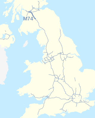
The A74(M) and M74 form a major motorway in Scotland, connecting it to England. The routes connect the M8 motorway in central Glasgow to the Scottish-English border at Gretna. They are part of the unsigned international E-road network E05. Although the entire route is colloquially referred to as the M74, for more than half its length, south of Abington, the road is officially the A74(M); see naming confusion below.

The Rottenrow is a street in the Townhead district of Glasgow, Scotland. One of the oldest streets in the city, it underwent heavy redevelopment in the 20th century and now forms part of the University of Strathclyde's John Anderson Campus. The street runs along the summit of a drumlin known historically as Balmanno Brae, although this name has long fallen from use.

The M77 motorway is a motorway in Scotland. It begins in Glasgow at the M8 motorway at Kinning Park, and terminates near Kilmarnock at Fenwick, becoming the A77 dual carriageway. Changes were made in 2005 segregating a lane on the M8 motorway almost as far as the Kingston Bridge, which in January 2006 was extended further onto the bridge itself. It forms the most northerly part of the A77 trunk road which links Glasgow to Stranraer in the South West of Scotland.

The A74, also known historically as the Glasgow to Carlisle Road, is a formerly major road in the United Kingdom, linking Glasgow in Scotland to Carlisle in North West England, passing through Clydesdale, Annandale and the Southern Uplands. It formed part of the longer route between Glasgow and London. A road has existed in this area since Roman Britain, and it was considered one of the most important roads in Scotland, being used as a regular mail service route.

The A728 is a route number in Glasgow, Scotland applied to two connected roads.
The Glasgow Inner Ring Road is a partially completed ring road encircling the city centre of Glasgow, Scotland. Construction of the roads began in 1965, and half of its circumference was completed by 1972 - forming part of the wider M8 motorway, but no further construction was made and the remaining plans were formally abandoned in 1980.

St George's Cross subway station is a Glasgow Subway station in Glasgow, Scotland which serves the areas of Woodside and Woodlands of the city. It is located at St George's Cross, previously an important road junction but realigned due to the construction of the M8 motorway and less heavily used by traffic since then. Today the station serves mainly the eastern extremity of Great Western Road and the northern reaches of the neighbouring Charing Cross district.

Charing Cross is a major road junction and area within the centre of Glasgow, Scotland. It is situated north of the River Clyde at the intersection of Sauchiehall Street, St George's Road, Woodlands Road, North Street and Newton Street, as well as being at a major interchange of the M8 motorway. Charing Cross marks the notional boundary between the City Centre and the West End of the city.

The A726 road in Scotland is a major route with several distinct sections with different characteristics and names; owing to its stages of construction, since 2005 it has two separate parts, the first running between Strathaven in South Lanarkshire and Junction 5 of the M77 motorway south of Newton Mearns in East Renfrewshire via East Kilbride, and the other running between Junction 3 of the M77 and the M898 motorway near the Erskine Bridge, via Paisley and Junction 29 of the M8 motorway near Glasgow International Airport.

The A730 road in Scotland runs between the centre of Glasgow and the south-eastern edge of the city's urban area at Cathkin.
Bridge to Nowhere is a nickname used to refer to various unfinished structures around the M8 motorway in the centre of Glasgow, Scotland. They were built in the 1960s as part of the Glasgow Inner Ring Road project but left incomplete for several years. One "bridge", at Charing Cross, was completed in the 1990s as an office block. The Anderston Footbridge, a pedestrian bridge south of St Patrick's church, was finally completed in 2013 as part of a walking and cycling route.

The A40 is a major trunk road connecting London to Fishguard, Wales. The A40 in London starts in the City of London and passes through six London Boroughs: Camden, Westminster, Kensington & Chelsea, Hammersmith & Fulham, Ealing and Hillingdon, to meet the M40 motorway junction 1 at Denham, Buckinghamshire.
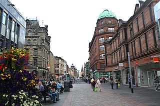
Argyle Street is a major thoroughfare in the city centre of Glasgow, Scotland.

The A749 road in Scotland connects East Kilbride with Glasgow city centre via Rutherglen and Bridgeton.
St Andrew's Cross, also known as Eglinton Toll, is a road junction in the south side of the city of Glasgow, Scotland. First constructed during the early 1800s, the junction formerly held several buildings including a power station and cinema, but have been removed for a variety of reasons. Since 1946 when the junction underwent a realignment, the two roads no longer intersect.

Sandyford is an area of Glasgow, Scotland. It is north of the River Clyde and forms part of the western periphery of the city centre. Formerly the name of a ward under Glasgow Town Council in the first part of the 20th century, it is within a continuous area of fairly dense urban development bordering several other neighbourhoods whose mutual boundaries have blurred over time, and is possibly less well known than all of the places which adjoin it, particularly Anderston and Finnieston.