Monroe or Monroes may refer to:

The Allegheny River is a 325-mile-long (523 km) headwater stream of the Ohio River that is located in western Pennsylvania and New York in the United States. It runs from its headwaters just below the middle of Pennsylvania's northern border, northwesterly into New York, then in a zigzag southwesterly across the border and through Western Pennsylvania to join the Monongahela River at the Forks of the Ohio at Point State Park in Downtown Pittsburgh, Pennsylvania.

Caroga is a town in Fulton County, New York, United States. The population was 1,205 at the 2010 census. The town was named after a local creek.

Arietta is a town in Hamilton County, New York, United States. The population was 304 at the 2010 census. The town was named after the mother of one of the first settlers, Rensselaer Van Rennslaer.

Benson is a town in Hamilton County, New York, United States. The population was 221 at the 2020 census. The town is on the southern border of Hamilton County and is northwest of Schenectady. The current Town Supervisor is John M. Stortecky.

Indian Lake is a town in Hamilton County, New York, United States. The population was 1,352 at the 2010 census. The name is from a lake of the same name that is largely inside the town. There are no permanent stop lights in the town. Law enforcement is provided by New York State Troopers and Hamilton County Sheriff's Office.

Wells is a town in Hamilton County, New York, United States. The population was 674 at the 2010 census. The town is named after Joshua Wells, a land agent, who built the first mills in the area. It is in the Adirondack Park and on the eastern border of the county. It is northwest of Schenectady.

Ohio is a town in Herkimer County, New York, United States. The population was 1,002 at the 2010 census. The town is named after the state of Ohio. The town is in the northern part of the county and northeast of Utica. Part of Ohio is within the Adirondack Park.

Webb is the northernmost town in Herkimer County, New York, United States. As of the 2010 census it had a population of 1,807.

Blooming Grove is a town in Orange County, New York, United States. The population was 18,811 at the 2020 census. It is located in the central part of the county, southwest of Newburgh.

Walton is a town in Delaware County, New York, United States. The population was 5,270 at the 2020 census. The town is in the west-central part of the county and contains the village of Walton. The town claims to be the "Scarecrow Capital of the World."

North Mountain is a peak in the Catskill Mountains of New York, on the border between the towns of Catskill and Hunter, in Greene County. It is part of the Catskill Escarpment. Cairo Round Top is located northeast and Artists Rock is located southeast of North Mountain.

The West Canada Creek is a 76-mile-long (122 km) river in upstate New York, United States. West Canada Creek is an important water way in Hamilton, Oneida, and Herkimer counties, draining the south part of the Adirondack Mountains before emptying into the Mohawk River near the Village of Herkimer. The name "Canada" is derived from an Iroquoian word for "village" (Kanata).

The Niagara Frontier refers to the stretch of land in the United States that is south of Lake Ontario and north of Lake Erie, and extends westward to Cleveland, Ohio. The term dates to the War of 1812, when the northern border was in contention between the United States and British forces in Canada. It refers only to the land east of the Niagara River and north of Lake Erie within the United States. The western side of the Niagara River, on the Canada/Ontario side, is the Niagara Peninsula; it is considered part of the Golden Horseshoe.

Lake Hope State Park is a public recreation area encompassing 2,983 acres (1,207 ha) within Zaleski State Forest, located five miles (8.0 km) northeast of Zaleski in Vinton County, Ohio. The state park is centered on Lake Hope, a 120-acre (49 ha) impoundment on Big Sandy Run.
Panther Mountain is a mountain located in Central New York of New York near Fly Creek, New York and Schuyler Lake, New York. The east side of Panther Mountain drains into Fly Creek and the west side drains into Oaks Creek and Canadarago Lake.
Canachagala Mountain is a summit located in Central New York Region of New York located in the Town of Ohio in Herkimer County, north of Wilmurt. Canachagala Lake is located north of Canachagala Mountain.
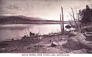
Mount Morris is a 3,117-foot-tall (950 m) mountain located in Adirondack Mountains of New York. It is located in the south-southwest of the village of Tupper Lake in Franklin County, and is "the highest peak immediately east of Tupper Lake." It is named after the town in which it was then located.

