Inkisiwi is a province in the La Paz Department in Bolivia. During the presidency of José Ballivián it was created on November 2, 1844. The capital of the province is Inkisiwi.
José Manuel Pando is a province in the La Paz Department in Bolivia. It was founded on April 22, 1986, during the presidency of Víctor Paz Estenssoro. The province was named after José Manuel Pando (1848-1917) who was the president of Bolivia from 1899 till 1904. Its capital is Santiago de Machaca.

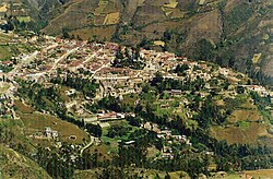
Larecaja is a province in the Bolivian La Paz Department. It was founded by Antonio José de Sucre on October 18, 1826. Its capital is Sorata.

Loayza or José Ramón Loayza is a province in the La Paz Department, Bolivia. Its seat is Luribay.

Omasuyos or Uma Suyu is a province in the La Paz Department in Bolivia. Its capital is Achacachi.

Pedro Domingo Murillo is a province in the Bolivian La Paz Department. It was created on January 8, 1838, with the name Cercado and on October 17, 1912, during the presidency of Eliodoro Villazón, its name was changed in honor of Pedro Domingo Murillo, protagonist of the revolution of June 16, 1809.
Sajama is a province in the northwestern parts of the Bolivian Oruro Department.
Batallas Municipality is the third municipal section of the Los Andes Province in the La Paz Department, Bolivia. Its capital is Batallas.

Janq'u Laymi (Aymara) is the second municipal section of the Omasuyos Province in the La Paz Department, Bolivia. Its seat is Ancoraimes.
Luribay Municipality is the first municipal section of the Loayza Province in the La Paz Department, Bolivia. Its seat is Luribay.
Catacora Municipality is the second municipal section of the José Manuel Pando Province in the La Paz Department, Bolivia. Its seat is Catacora.
Malla Municipality is the fourth municipal section of the Loayza Province in the La Paz Department, Bolivia. Its seat is Malla.
Wila Quta is a mountain in the Andes of Bolivia, about 4,960 metres (16,273 ft) high. It is situated in the La Paz Department, Larecaja Province, Sorata Municipality, north of the massif of Janq'u Uma and Illampu of the Cordillera Real. The river Janq'u Uma Jawira originates south of the mountain. It flows to the north-east.
Ch'uch'u Jawira is a Bolivian river in the La Paz Department, Larecaja Province, Sorata Municipality. Its waters flow the Kaka River which belongs to the watershed of the Beni River.
Ch'uch'u Apachita is a 4,855-metre-high (15,928 ft) mountain in the Andes of Bolivia. It is situated in the La Paz Department, Larecaja Province, Sorata Municipality. Ch'uch'u Apachita lies north of the main range of the Cordillera Real, south to southwest of the mountain Ch'uch'u, northwest of Chunta Qullu and east of Jukumarini. This is where the river Ch'uch'u Jawira originates.
Jukumarini is a 4,552-metre-high (14,934 ft) mountain in the Andes of Bolivia. It is situated in the La Paz Department, Larecaja Province, Sorata Municipality. Jukumarini lies north of the main range of the Cordillera Real, southwest of the mountain Ch'uch'u and west of Ch'uch'u Apachita.
Ch'uxña Quta is a 4,907-metre-high (16,099 ft) mountain in the Andes of Bolivia. It is situated in the La Paz Department, Larecaja Province, Sorata Municipality. Ch'uxña Quta lies in the northern extensions of the Cordillera Real southeast of the mountains Ch'uch'u and Ch'uch'u Apachita and northwest of Llawi Imaña.
Jach'a Waylla Punta is a 4,743-metre-high (15,561 ft) mountain in the Andes of Bolivia. It is located in the La Paz Department, Larecaja Province, Sorata Municipality. Jach'a Waylla Punta lies in the northern extensions of the Cordillera Real southeast of the mountain Wila Wilani and south of Wankar Quta Qullu. It is situated at the rivers Q'asiri Jawira and Ch'uch'u Jawira.
Ch'uxñani is a 4,680-metre-high (15,354 ft) mountain in the Andes of Bolivia. It is located in the La Paz Department, Larecaja Province, Sorata Municipality, in the northern extensions of the Cordillera Real southeast of the mountain Jach'a Waylla Punta. Ch'uxñani lies near the confluence of the rivers Ch'uch'u Jawira which comes from the northwest and Jach'a Uma Jawira which originates between the mountain Wila Quta and the Janq'u Uma-Illampu massif.
Qala Phusa is a 4,884-metre-high (16,024 ft) mountain in the Andes of Bolivia. It is situated in the La Paz Department, Larecaja Province, Sorata Municipality. Qala Phusa lies north of the Janq'u Uma-Illampu massif of the Cordillera Real, northwest of the mountain Wila Quta and southeast of Llawi Imaña.