Related Research Articles

Sylvania is a town in DeKalb County, Alabama, United States. It incorporated in October 1967. At the 2010 census the population was 1,837, up from 1,186 in 2000. Sylvania is located atop Sand Mountain.

Tuscarora township is a township in Steuben County, New York, United States. The population was 1,400 at the 2000 census. The township is named after the Tuscarora tribe.

St. James is a hamlet and census-designated place (CDP) in Suffolk County, New York, United States. The population of the CDP was 13,338 at the 2010 census. St. James is part of the Town of Smithtown and is located on the North Shore of Long Island. The ZIP code is 11780.

The Struve Geodetic Arc is a chain of survey triangulations stretching from Hammerfest in Norway to the Black Sea, through ten countries and over 2,820 km, which yielded the first accurate measurement of a meridian arc.

Kırıkkale Province is a province of Turkey. It is located on the crossroads of major highways east of Ankara leading east to the Black Sea region. With its rapid population growth it has become an industrial center. The provincial capital is Kırıkkale.
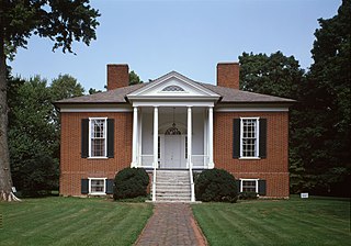
Hawthorne is a neighborhood in eastern Louisville, Kentucky, United States. Its boundaries are Taylorsville Road, Hawthorne Avenue, Bardstown Road and I-264. The land was once part of John Speed's Farmington estate, known for its plantation house built around 1815–16. The neighborhood is primarily residential and was first subdivided in 1909, but saw its fastest grown in the 1920s. It takes its name from Hawthorne Avenue, and most of the other streets are named after writers or poets. Sullivan University is located in the neighborhood.

Grand Valley is an unincorporated community in Tallmadge Charter Township in the U.S. state of Michigan. The community is on M-45 just east of the Grand River at 42°58′28″N85°52′11″W. The valley is about a mile (1.4 km) wide here and somewhat wider just to the south, with steep bluffs on the western and southern side of the river.

Riverside Gardens is a neighborhood of Louisville, Kentucky centered along Campground Road and Lees Lane. In 2007, the first stretch of the proposed 110-mile Louisville Loop bike and pedestrian trail was completed to Lees Lane in Riverside Gardens from Riverview Park. The project included a $2 million bridge over Mill Creek. The concrete trail is expected to be connected to Shawnee Park by spring of 2008. In the future, a wharf and riverfront park is planned for Riverside Gardens.
Medora is a neighborhood of Louisville, Kentucky, centered along Pendleton Road and Medora Road.
Valley Gardens is a neighborhood of Louisville, Kentucky, in the United States. It is centered along Johnsontown Road and Terry Road.
Valley Downs is a neighborhood of Louisville, Kentucky, USA located along Omar Khayyam Boulevard south of Johnsontown Road.
Basra, nicknamed Basra al-Hamra, is an archaeological site in Morocco. It was originally a summer capital of the Idrisid dynasty from the 8th to 10th centuries.
Springhills is an unincorporated community in northwestern Harrison Township, Champaign County, Ohio, United States. It lies at the intersection of State Route 245 with Crowl and Springhill-DeGraff Roads. Graves Creek, a subsidiary of the Great Miami River through Stony Creek, runs along the western edge of Springhills. It is located 6 miles (9.5 km) west of West Liberty and 11.5 miles (18.5 km) northwest of Urbana, the county seat of Champaign County.

Guil Station is a subway station in Seoul, South Korea, that serves Seoul Subway Line 1. The name of this station comes from its location within Guro 1 -dong. Dongyang Mirae University is located nearby.

Braysville is an unincorporated community in Harrison Township, Dearborn County, Indiana.
WROM is a commercial AM radio station in Rome, Georgia. It airs a variety hits radio format blending Top 40, Dance, Alternative and Rock music. The station is owned by Howard Toole, with Rome Radio Partners, LLC, holding the broadcast license.
Notchko is a locality in Humboldt County, California. It is located on the Klamath River 4 miles (6.4 km) south of Johnsons, at an elevation of 151 feet (46 m).
Wilder is an unincorporated community in Johnson County, Kansas, United States, and part of the Kansas City metropolitan area. It is located at 39°02′35″N94°52′11″W.

Survant is an unincorporated community in Marion Township, Pike County, in the U.S. state of Indiana.

Kitchen is an unincorporated community in Madison Township, Jackson County, Ohio, United States. It is located southeast of Oak Hill at the intersection of Ohio State Route 233 and CH&D Road, at 38°52′11″N82°32′34″W.
References
- ^ "HomeTownLocator" . Retrieved 2006-06-10.
