
Mountain Province is a landlocked province of the Philippines in the Cordillera Administrative Region in Luzon. Its capital is Bontoc.
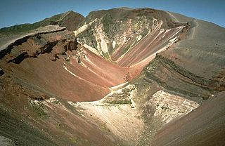
Mount Tarawera is a volcano on the North Island of New Zealand. Located 24 kilometres southeast of Rotorua, it consists of a series of rhyolitic lava domes that were fissured down the middle by an explosive basaltic eruption in 1886. This eruption was one of New Zealand's largest historical eruptions, and killed an estimated 120 people. The fissures run for about 17 kilometres northeast-southwest.
Terrace is a city located near the Skeena River in British Columbia, Canada. The community is the regional retail and service hub for the northwestern portion of British Columbia. With a current population of over 12,000 within municipal boundaries, the city services surrounding communities as well bringing the Greater Terrace Area population to over 18,000 residents. The Kitselas and Kitsumkalum people, tribes of the Tsimshian Nation, have lived in the Terrace area for thousands of years. The individual Indigenous communities neighbour the city with Kitselas to the east and Kitsumkalum to the west.

Trevélez is a village in the province of Granada, Spain. Its population in 2011 was estimated at 823. The river Trevélez flows through the village. They are located in the western part of the Alpujarras region. Two of the highest mountains in Spain, Mulhacén and Alcazaba, are just to the north of the village, a few hours' walk away.
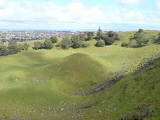
Māngere Mountain is a volcanic cone in Māngere, Auckland. Located within Māngere Domain, it is one of the largest volcanic cones in the Auckland volcanic field, with a peak 106 metres (348 ft) above sea level. It was the site of a major pā and many of the pā's earthworks are still visible. It has extensive panoramic views of Auckland from its location in the southeastern portion of the city's urban area. It is also known as Te Pane-o-Mataaho, and Te Ara Pueru.

Kigezi District once covered what are now Kabale District, Kanungu District, Kisoro District and Rukungiri District, in southwest Uganda. Its terraced fields are what gives this part of Uganda its distinctive character. Kigezi was popularly known as the Switzerland of Africa. The coordinates for the region are: Latitude:01 13 20S, 29 53 20E.

Loudi is a prefecture-level city located in central Hunan province, China. It is situated about 110 km (68 mi) southwest of the provincial capital of Changsha and is considered a small to medium size city within the province. According to the 2010 Census, the population of Loudi is of 3,785,627 inhabitants in an area of 8,117 km2 (3,134 sq mi). In 2007, the city is named China's top ten livable cities by Chinese Cities Brand Value Report, which was released at 2007 Beijing Summit of China Cities Forum.
The Musashino Plateau, also translated as Musashino Platform and also named as Musashino Region, is a large tableland in the Kantō region of Honshu, Japan.
Mount Weeks, formerly Round Mountain, is a mountain located in Coos County, New Hampshire. Mt. Weeks is the northeasternmost of the Pliny Range of the White Mountains and the highest point within the city limits of Berlin, New Hampshire. Mount Weeks is flanked to the southwest by South Weeks, and faces Terrace Mountain to the northwest across Willard Notch.

The Passumpsic River is a 22.7-mile-long (36.5 km) tributary of the Connecticut River, in Vermont. Though primarily a Caledonia County river, it is the only river to flow through all three counties of the Northeast Kingdom.

Wittenberg Mountain, locally "the Wittenberg," is a mountain located in Ulster County, New York. The mountain is part of the Burroughs Range of the Catskill Mountains. Wittenberg is flanked to the southwest by Cornell Mountain and to the northeast by Terrace Mountain.
Horneline Creek Provincial Park is a provincial park in far northern British Columbia, Canada. It is located west of the Kechika River about 130 km south of Lower Post and 30 km north of Denetiah Provincial Park and southwest of the community of Liard River.

Terrace Mountain is a mountain peak in the Gallatin Range in Yellowstone National Park in Park County, Wyoming, United States. The mountain is located 2.2 miles (3.5 km) southwest of Mammoth Hot Springs. Terrace Mountain was named by the 1878 Hayden Geological Survey because of its proximity to the travertine terraces at Mammoth and because it too is an ancient travertine terrace. The mountain has also been known as "Soda Mountain" and "White Mountain".
Twin Peaks is an unincorporated community in San Bernardino County, California, United States, located on California State Route 189 2.5 miles (4.0 km) west-southwest of Lake Arrowhead. Twin Peaks has a post office with ZIP code 92391, which opened in 1916.

The Daba Mountains, also known by their Chinese name as the Dabashan, are a mountain range in Central China between the watersheds of the Yellow and Yangtze Rivers. Part of the larger Qinling mountain range, it cuts through four provinces: Sichuan, Chongqing, Shaanxi, and Hubei. It is about 1,000 kilometers (620 mi) long.

The Torino Hut is a high mountain refuge in the Alps in northwestern Italy. Located near the border with France, it is about 15 km (10 mi) southwest of Mont Dolent, the tripoint with Switzerland. The refuge is in the Mont Blanc massif above the town of Courmayeur in the Aosta Valley, Italy. It can be most easily accessed from the Italian side by the Skyway Monte Bianco cable car from La Palud in Courmayeur, with a change at the Pavilion du Mont Fréty. It can also be reached from Chamonix via the Aiguille du Midi, either by cable car which crosses the massif, or by a long crossing of the Glacier du Gèant. The refuge lies nearly directly above the 11.6 km (7.2 mi) Mont Blanc Tunnel, which passes deep underground, and connects Courmayer to Chamonix.

The Cedar Valley of Iron County, Utah, United States is a 25-mile (40 km) long valley located in the southeast of the county, against the Hurricane Cliffs which border the Cedar Mountains and the Markagunt Plateau.
The Pilot Range is located in the White Mountains of New Hampshire in the United States. The Pilot Range extends southeast-northwest about 15 miles (24 km). The highest peak in the range is Mount Cabot, with an elevation of 4,160 feet (1,270 m).
Fork Ridge is a ridge located in the Catskill Mountains of New York south-southwest of Phoenicia. Wittenberg Mountain is located southeast, Terrace Mountain is located east-southeast, and Garfield Mountain is located north of Fork Ridge.

The Fifa Mountains or Faifa Mountains are located in the vicinity of the town of Faifa' in South Province, southwest Saudi Arabia.

