Tigerton, Wisconsin

Last updated

Tigerton, Wisconsin
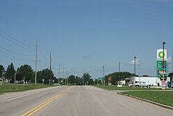
Tigerton Wisconsin Downtown North US45.jpg
U.S. Route 45 in Tigerton
Shawano County Wisconsin Incorporated and Unincorporated areas Tigerton Highlighted.svg
Location of Tigerton in Shawano County, Wisconsin.
Coordinates: 44°44′25″N89°3′30″W / 44.74028°N 89.05833°W / 44.74028; -89.05833
Country Flag of the United States.svg  United States
State Flag of Wisconsin.svg  Wisconsin
County Shawano
Area
[1]
  Total1.85 sq mi (4.79 km2)
  Land1.82 sq mi (4.72 km2)
  Water0.03 sq mi (0.06 km2)
Elevation
[2]
1,030 ft (314 m)
Population
 (2010) [3]
  Total741
  Estimate 
(2019) [4]
705
  Density386.51/sq mi (149.23/km2)
Time zone UTC-6 (Central (CST))
  Summer (DST) UTC-5 (CDT)
Area code(s) 715 & 534
FIPS code 55-79825 [5]
GNIS feature ID1575448 [2]
Website www.tigertonwis.com

Tigerton is a village in Shawano County, Wisconsin, United States. The population was 741 at the 2010 census.

Contents

History

The Lake Shore Railroad ran through the area from 1879 to 1981. [6] Established in 1896, [7] the village is named after Tiger Creek. [8] The creek is said to have fast-running waters that roar like a tiger. [9]

In the 1970s and 1980s, Tigerton was the Wisconsin base of the now largely defunct Posse Comitatus, a militant far-right organization. [10] [11]

Geography

Tigerton is located at 44°44′25″N89°3′30″W / 44.74028°N 89.05833°W / 44.74028; -89.05833 (44.740411, -89.058261). [12]

According to the United States Census Bureau, the village has a total area of 1.82 square miles (4.71 km2), of which, 1.79 square miles (4.64 km2) of it is land and 0.03 square miles (0.08 km2) is water. [13]

Demographics

Historical population
CensusPop.Note
1900 723
1910 7280.7%
1920 7482.7%
1930 83111.1%
1940 794−4.5%
1950 8274.2%
1960 781−5.6%
1970 742−5.0%
1980 86516.6%
1990 815−5.8%
2000 764−6.3%
2010 741−3.0%
2019 (est.)705 [4] −4.9%
U.S. Decennial Census [14]
Village Hall Tigerton Village Hall and Engine House.jpg
Village Hall

2010 census

As of the census [3] of 2010, there were 741 people, 332 households, and 182 families living in the village. The population density was 414.0 inhabitants per square mile (159.8/km2). There were 378 housing units at an average density of 211.2 per square mile (81.5/km2). The racial makeup of the village was 92.3% White, 0.3% African American, 3.2% Native American, 0.3% Asian, 1.5% from other races, and 2.4% from two or more races. Hispanic or Latino of any race were 1.9% of the population.

There were 332 households, of which 25.9% had children under the age of 18 living with them, 39.2% were married couples living together, 9.9% had a female householder with no husband present, 5.7% had a male householder with no wife present, and 45.2% were non-families. 38.0% of all households were made up of individuals, and 19% had someone living alone who was 65 years of age or older. The average household size was 2.23 and the average family size was 2.98.

The median age in the village was 40.2 years. 23.8% of residents were under the age of 18; 7.3% were between the ages of 18 and 24; 23.5% were from 25 to 44; 28.6% were from 45 to 64; and 16.7% were 65 years of age or older. The gender makeup of the village was 48.7% male and 51.3% female.

2000 census

As of the census [5] of 2000, there were 764 people, 349 households, and 199 families living in the village. The population density was 540.1 people per square mile (209.2/km2). There were 383 housing units at an average density of 270.7 per square mile (104.9/km2). The racial makeup of the village was 97.12% White, 0.13% African American, 1.96%, Native American, 0.13% Asian, and 0.65% from two or more races. Hispanic or Latino of any race were 1.05% of the population.

There were 349 households, out of which 26.4% had children under the age of 18 living with them, 45.0% were married couples living together, 9.2% had a female householder with no husband present, and 42.7% were non-families. 40.1% of all households were made up of individuals, and 21.5% had someone living alone who was 65 years of age or older. The average household size was 2.19 and the average family size was 2.93.

In the village, the population was spread out, with 23.3% under the age of 18, 6.3% from 18 to 24, 28.1% from 25 to 44, 20.9% from 45 to 64, and 21.3% who were 65 years of age or older. The median age was 40 years. For every 100 females, there were 83.2 males. For every 100 females age 18 and over, there were 83.7 males.

The median income for a household in the village was $25,278, and the median income for a family was $33,625. Males had a median income of $26,250 versus $18,264 for females. The per capita income for the village was $14,707. About 9.4% of families and 15.6% of the population were below the poverty line, including 18.6% of those under age 18 and 13.6% of those age 65 or over.
Education

The village is served by the Tigerton School District. The district has an elementary school, middle school and high school, as well as the Tigerton School Forest and Environmental Center, a hands-on learning environment. [15] [16] [17]

Notable people

Related Research Articles

<span class="mw-page-title-main">Pardeeville, Wisconsin</span> Village in Wisconsin, United States

Pardeeville is a village in Columbia County, Wisconsin, United States. The population was 2,115 at the 2010 census. It is part of the Madison Metropolitan Statistical Area.

<span class="mw-page-title-main">Boyceville, Wisconsin</span> Village in Wisconsin, United States

Boyceville is a village in Dunn County, Wisconsin, United States. The population was 1,100 at the 2020 census.

<span class="mw-page-title-main">Fall Creek, Wisconsin</span> Village in Wisconsin, United States

Fall Creek is a village in Eau Claire County, Wisconsin, United States. The population was 1,315 at the 2010 census. The village is bordered by the Town of Lincoln.

<span class="mw-page-title-main">Monticello, Green County, Wisconsin</span> Village in Wisconsin, United States

Monticello is a village in Green County, Wisconsin, United States. The population was 1,217 as of the 2010 census.

<span class="mw-page-title-main">Cleveland (village), Wisconsin</span> Village in Wisconsin, United States

Cleveland is a village in Manitowoc County, Wisconsin, United States. The population was 1,579 at the 2020 census.

<span class="mw-page-title-main">Maribel, Wisconsin</span> Village in Wisconsin, United States

Maribel is a village in Manitowoc County, Wisconsin, United States. The population was 336 at the 2020 census.

<span class="mw-page-title-main">Bonduel, Wisconsin</span> Village in Wisconsin, United States

Bonduel is a village in Shawano County, Wisconsin, United States. The population was 1,417 at the 2020 census, and 1,478 at the 2010 census.

<span class="mw-page-title-main">Pigeon Falls, Wisconsin</span> Village in Wisconsin, United States

Pigeon Falls is a village in Trempealeau County, Wisconsin, United States. The population was 411 at the 2010 census.

<span class="mw-page-title-main">Lannon, Wisconsin</span> Village in Wisconsin, United States

Lannon is a village in Waukesha County, Wisconsin, United States. The population was 1,355 at the 2020 census. Lannon is a part of the Milwaukee metropolitan area.

<span class="mw-page-title-main">Stockbridge, Wisconsin</span> Village in Wisconsin, United States

Stockbridge is a village in Calumet County, Wisconsin, United States. The population was 678 at the 2020 census. The village lies within the Town of Stockbridge.

<span class="mw-page-title-main">Unity, Wisconsin</span> Village in Wisconsin, United States

Unity is a village in Clark and Marathon counties in the U.S. state of Wisconsin. It is part of the Wausau, Wisconsin Metropolitan Statistical Area. The population was 343 at the 2010 census. Of this, 204 were in Marathon County, and 139 were in Clark County. The village is located in northeastern town of Unity in Clark County and northwestern town of Brighton in Marathon County.

<span class="mw-page-title-main">Randolph, Wisconsin</span> Village in Wisconsin, United States

Randolph is a village in Columbia and Dodge Counties in the U.S. state of Wisconsin. The population was 1,811 at the 2010 census. Of this, 1,339 were in Dodge County, and 472 were in Columbia County. The village is located at the southeast corner of the Town of Randolph in Columbia County, although only a tiny portion of the village lies within the town. Most of the village lies within the Town of Westford in Dodge County. Small portions also lie within the Town of Fox Lake to the north and the Town of Courtland in Columbia County.

<span class="mw-page-title-main">Lowell, Wisconsin</span> Village in Wisconsin, United States

Lowell is a village in Dodge County, Wisconsin, United States, along the Beaver Dam River. The population was 340 at the 2010 census. The village is located within the Town of Lowell.

<span class="mw-page-title-main">Arena, Wisconsin</span> Village in Wisconsin, United States

Arena is a village in Iowa County, Wisconsin, United States. The population was 834 at the 2010 census. The village is located within the Town of Arena. It is part of the Madison Metropolitan Statistical Area.

<span class="mw-page-title-main">Belmont, Wisconsin</span> Village in Wisconsin, United States

Belmont is a village in Lafayette County, Wisconsin, United States. The population was 989 at the 2020 census. It was the original capital of the Wisconsin Territory during the first legislative assembly in 1836.

<span class="mw-page-title-main">Weston, Wisconsin</span> Village in Wisconsin, United States

Weston is a village in Marathon County, Wisconsin. It is part of the Wausau Metropolitan Statistical Area. The population was 14,868 at the time of the 2010 census.

<span class="mw-page-title-main">Pound, Wisconsin</span> Village in Wisconsin, United States

Pound is a village in Marinette County, Wisconsin, United States. The population was 377 at the 2010 census. The village is located within the Town of Pound. Pound is part of the Marinette, WI– MI Micropolitan Statistical Area.

<span class="mw-page-title-main">Milltown, Wisconsin</span> Village in Wisconsin, United States

Milltown is a village in Polk County, Wisconsin, United States. The population was 917 at the 2010 census. The village is located within the Town of Milltown.

<span class="mw-page-title-main">Almond, Wisconsin</span> Village in the United States

Almond is a village in Portage County, Wisconsin, United States. The population was 448 at the 2010 census.

<span class="mw-page-title-main">Ironton, Wisconsin</span> Village in Wisconsin, United States

Ironton is a village in Sauk County, Wisconsin, United States, along the Little Baraboo River. The population was 253 at the 2010 census. The village is located within the Town of Ironton.

References

  1. "2019 U.S. Gazetteer Files". United States Census Bureau. Retrieved August 7, 2020.
  2. 1 2 "US Board on Geographic Names". United States Geological Survey. October 25, 2007. Retrieved January 31, 2008.
  3. 1 2 "U.S. Census website". United States Census Bureau . Retrieved November 18, 2012.
  4. 1 2 "Population and Housing Unit Estimates". United States Census Bureau. May 24, 2020. Retrieved May 27, 2020.
  5. 1 2 "U.S. Census website". United States Census Bureau . Retrieved January 31, 2008.
  6. "A Brief History of the Village of Tigerton". Official Website of Tigerton Wisconsin. Archived from the original on March 10, 2016. Retrieved February 26, 2014.
  7. "Tigerton, Wisconsin". Archived from the original on February 26, 2014. Retrieved February 24, 2014.
  8. Chicago and North Western Railway Company (1908). A History of the Origin of the Place Names Connected with the Chicago & North Western and Chicago, St. Paul, Minneapolis & Omaha Railways. p. 130.
  9. "Profile for Tigerton, Wisconsin, WI". ePodunk. Retrieved February 26, 2014.
  10. "With Leaders in Jail, Posse Comitatus' Fate Is Uncertain". Los Angeles Times. September 23, 1990.
  11. "Posse Comitatus Manual Urged Terrorism Sheriff Says". Associated Press. September 12, 1985.
  12. "US Gazetteer files: 2010, 2000, and 1990". United States Census Bureau. February 12, 2011. Retrieved April 23, 2011.
  13. "US Gazetteer files 2010". United States Census Bureau. Archived from the original on January 25, 2012. Retrieved November 18, 2012.
  14. "Census of Population and Housing". Census.gov. Retrieved June 4, 2015.
  15. "The School District of Tigerton". Village of Tigerton. Retrieved February 26, 2014.
  16. "Tigerton School District". Tigerton School District. Retrieved February 26, 2014.
  17. "Tigerton School District". Great Schools. Retrieved February 26, 2014.
  18. "Abrahamson, Theodore 1900". Wisconsin Historical Society. Retrieved January 10, 2012.
  19. 'Wisconsin Blue Book 1933,' Biographical Sketch of Joseph H. Hardgrove, pg. 235