West Portland Park, Portland, Oregon

Last updated
West Portland Park
Neighborhood
Portland map.png
Red pog.svg
West Portland Park
Coordinates: 45°26′N122°43′W / 45.44°N 122.72°W / 45.44; -122.72 Coordinates: 45°26′N122°43′W / 45.44°N 122.72°W / 45.44; -122.72 PDF map
Country United States
State Oregon
City Portland
Government
  AssociationWest Portland Park Neighborhood Association
  Coalition Southwest Neighborhoods, Inc.
Area
  Total0.73 sq mi (1.88 km2)
Population
(2000) [1]
  Total3,775
  Density5,200/sq mi (2,000/km2)
Housing
[1]
  No. of households1570
  Occupancy rate93% occupied
  Owner-occupied813 households (52%)
  Renting757 households (48%)
  Avg. household size2.40 persons

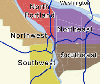
West Portland Park is a neighborhood in the Southwest section of Portland, Oregon. It lies between SW 53rd Ave. in the west and SW 35th Ave. in the east, and I-5 in the north and SW Stephenson St. (Portland city limits) in the south. (Two small sections extend further south, a parcel at the end of SW 47th Ave. and the "Kerr Site" between SW 39th Ave. and SW 37th Ave., following irregularities in Portland's southern border.) South of SW Pomona St., the western border is SW 49th Ave. The neighborhood borders Crestwood and Far Southwest to the west, Multnomah to the north, Markham and Arnold Creek to the east, and the city of Lake Oswego to the south.

Portland, Oregon City in Oregon, United States

Portland is the largest and most populous city in the U.S. state of Oregon and the seat of Multnomah County. It is a major port in the Willamette Valley region of the Pacific Northwest, at the confluence of the Willamette and Columbia rivers. As of 2017, Portland had an estimated population of 647,805, making it the 26th most populated city in the United States, and the second-most populous in the Pacific Northwest. Approximately 2.4 million people live in the Portland metropolitan statistical area (MSA), making it the 25th most populous MSA in the United States. Its Combined Statistical Area (CSA) ranks 18th-largest with a population of around 3.2 million. Approximately 60% of Oregon's population resides within the Portland metropolitan area.

Interstate 5 Interstate along the West Coast of the US

Interstate 5 (I-5) is the main Interstate Highway on the West Coast of the United States, running largely parallel to the Pacific coast of the contiguous U.S. from Mexico to Canada. It travels through the states of California, Oregon, and Washington, serving several large cities on the U.S. West Coast, including San Diego, Los Angeles, Sacramento, Portland, and Seattle. It is currently the only continuous Interstate highway to touch both the Mexican border and the Canadian border. Upon crossing the Mexican border at its southern terminus, Interstate 5 continues to Tijuana, Baja California as Mexico Federal Highway 1. Upon crossing the Canadian border at its northern terminus, it continues to Vancouver as British Columbia Highway 99.

Crestwood, Portland, Oregon Neighborhood in Portland, Oregon, United States

Crestwood is a neighborhood in the Southwest section of Portland, Oregon located between SW 45th Ave. and Barbur Blvd., adjacent to Multnomah and Ashcreek. Woods Memorial Natural Area is located here, a swath of urban wilderness visited on occasion by elk.

West Portland Park neighborhood street sign topper West Portland Park SW Pomona St.jpeg
West Portland Park neighborhood street sign topper

The northern part of the neighborhood is called Capitol Hill, site of the Capitol Hill Library, the Islamic Center of Portland, the Portland Rizwan Mosque (of the Ahmadiyya Muslim Community), and the Islamic School of Portland.

Jackson Middle School and Markham Elementary School are in West Portland Park.

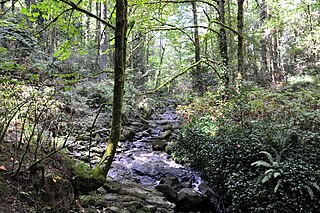
Public open space in the neighborhood includes the Kerr Site, which was purchased jointly by the City of Portland and City of Lake Oswego with the intent of eventually installing walking trails; Loll Wildwood, the Metro greenspace at the headwaters of Arnold Creek, formerly known as the West Portland Park Natural Area (purchased in 1995 for protection of wildlife habitat and water quality); and the Holly Farm Park, completed in 2007 after a partnership between the Parks Foundation, Portland Parks & Recreation, and the West Portland Park Neighborhood Association.

Portland Parks & Recreation (PP&R) is a Buerau of the City of Portland, Oregon that manages the city parks, natural areas, recreational facilities, gardens, and trails. The properties, which occupy a total of more than 10,000 acres (4,000 ha). The bureau employs a total of 4,366 employees as of March 4, 2019. 3,752 are casual, 559 are regular and the remainder are other categories.

Related Research Articles

Delridge, Seattle

Delridge is a district in West Seattle, Washington, United States that stretches along Delridge Way, an arterial that follows the eastern slope of the valley of Longfellow Creek, from near its source just within the southern city limits north to the West Seattle Bridge over the Duwamish River.

Multnomah, Portland, Oregon Neighborhood in Portland, Oregon, United States

Multnomah is a neighborhood in the southwest section of Portland, Oregon, centered on the Multnomah Village business district. The community developed in the 1910s around a depot of the Oregon Electric Railway of the same name. It was annexed by the city of Portland on November 7, 1950.

Kings Hill/Southwest Salmon Street station

Kings Hill/Southwest Salmon Street is a light rail station on the MAX Blue and Red Lines in the Goose Hollow neighborhood of Portland, Oregon. Its incorrectly punctuated name refers to the hillside to the west of the station, which has historically been referred to as King's Hill. A section of King's Hill, which contains many historic buildings, qualified for inclusion within the King's Hill Historic District, the easternmost boundary of which is at SW 21st Avenue. The station is located in the center of SW 18th Avenue and has a single platform between the tracks. The platforms are accessed from the left-hand side of the train.

Oregon Route 43 highway in Oregon

Oregon Route 43 is an Oregon state highway that runs between the cities of Oregon City and Portland, mostly along the western flank of the Willamette River. While it is technically known by the Oregon Department of Transportation as the Oswego Highway No. 3, on maps it is referred to by its route number or by the various street names it has been given.

Hillsdale, Portland, Oregon Neighborhood in Portland, Oregon, United States

The Hillsdale district is a neighborhood in the southwest section of Portland, Oregon, United States. It is centered on the Hillsdale retail and business area, a series of strip malls on SW Capitol Highway between SW Sunset Boulevard and SW Bertha Boulevard. It is home to the Hillsdale Farmer's Market, which takes place on Sundays during the summer and every other Sunday during the winter. Hillsdale is also home to Oregon's first brewpub, with the opening of McMenamins Hillsdale Brewery in 1985.

Maplewood, Portland, Oregon Neighborhood in Portland, Oregon, United States

Maplewood is a suburban neighborhood in Southwest Portland, Oregon, United States.

South Portland, Portland, Oregon Neighborhood in Portland, Oregon, United States

South Portland is a long, narrow neighborhood just south of Downtown Portland, Oregon, hemmed in between the Willamette River and the West Hills. It stretches from I-405 and the Marquam Bridge on the north, to SW Canby St. and the Sellwood Bridge in the south. The Willamette forms the eastern boundary, and SW Barbur Blvd. most of the western boundary. In addition to Downtown to the north, other bordering neighborhoods are Southwest Hills, Homestead, Hillsdale, and South Burlingame to the west, and Hosford-Abernethy, Brooklyn, and Sellwood-Moreland across the river on the east.

Goose Hollow, Portland, Oregon Neighborhood in Portland, Oregon, United States

Goose Hollow is a neighborhood in southwest Portland, Oregon, United States. It acquired its distinctive name through early residents' practice of letting their geese run free in Tanner Creek Gulch and near the wooded ravine in the Tualatin Mountains known as the Tanner Creek Canyon. Tanner Creek Gulch was a 20-block-long, 50-foot-deep (15 m) gulch that started around SW 17th and Jefferson and carried the waters of Tanner Creek into Couch Lake. Over a century ago, Tanner Creek was buried 50 feet (15 m) underground, and the Tanner Creek Gulch was infilled. Thus, the only remaining part of the hollow is the ravine carved out by Tanner Creek through which The Sunset Highway carrying US-26 passes and which the Vista Bridge spans.

Bridlemile, Portland, Oregon Neighborhood in Portland, Oregon, United States

Bridlemile is a Southwest Portland, Oregon neighborhood in the West Hills. The Portland city boundary runs through the neighborhood such that the southern part of the neighborhood is within Portland proper, but the northern portion is unincorporated Multnomah County. The portion within Portland city limits extends into Washington County in two places.

Southwest Hills, Portland, Oregon Neighborhood in Portland, Oregon, United States

Southwest Hills is a neighborhood in the West Hills in the southwest section of Portland, Oregon, United States. The northeastern part of the neighborhood, above Goose Hollow and Downtown Portland, is known as Portland Heights. Much of the western portion of the neighborhood lies outside the Portland city limits, in unincorporated Multnomah County.

Arnold Creek, Portland, Oregon Neighborhood in Portland, Oregon, United States

Arnold Creek is a neighborhood in the Southwest section of Portland, Oregon, just north of the city of Lake Oswego and Clackamas County. It borders West Portland Park to the west, Markham and Marshall Park to the north, Collins View and Tryon Creek State Natural Area to the east, and Lake Oswego and the unincorporated Multnomah County enclave of Englewood to the south.

Buckman, Portland, Oregon Neighborhood in Portland, Oregon, United States

Buckman is a neighborhood in the Southeast section of Portland, Oregon. The neighborhood is bounded by the Willamette River on the west, E Burnside St. on the north, SE 28th Ave. on the east, and SE Hawthorne Blvd. on the south.

Neighborhoods of Portland, Oregon

There are five sections of Portland, Oregon, though a sixth is planned, and 95 officially recognized neighborhoods, each of which is represented by a volunteer-based neighborhood association. These associations serve as the liaison between residents and the city government, as coordinated by the city's Office of Community & Civic Life, which was created in 1974 and known as the Office of Neighborhood Involvement until July 2018. The city subsequently provides funding to this "network of neighborhoods" through district coalitions, which are groupings of neighborhood associations. On June 6, 2018, Portland City Council voted to add a sixth section to Portland; it will be called South Portland and the transition to the new system is expected to start in May 2020.

Far Southwest, Portland, Oregon Neighborhood in Portland, Oregon, United States

Far Southwest is a neighborhood in the Southwest section of Portland, Oregon. It is bordered on the west by I-5; on the north by I-5, SW Pasadena St., and SW Pomona St.; on the east by SW 49th Ave. and Kerr Parkway; and on the south by SW Kruse Ridge Dr. and the southern border of the Portland Community College Sylvania Campus. The neighborhood is adjacent to the city of Tigard on the west, the neighborhoods of Ashcreek and Crestwood on the north, West Portland Park on the north and east, and the city of Lake Oswego on the east and south.

Markham, Portland, Oregon Neighborhood in Portland, Oregon, United States

Markham is a neighborhood in the Southwest section of Portland, Oregon. Markham is bordered by Multnomah and South Burlingame on the north, Marshall Park on the east, Arnold Creek on the south, and West Portland Park on the west.

Marshall Park, Portland, Oregon Neighborhood in Portland, Oregon, United States

Marshall Park is a neighborhood in the Southwest section of Portland, Oregon. It gets its name from the adjacent Marshall Park donated to the City of Portland by Frederick C. and Addie Mae Marshall in 1948. It borders Markham to the west and north, South Burlingame to the north, Collins View to the east, and Arnold Creek to the south.

Tryon Creek tributary of the Willamette River in Oregon

Tryon Creek is a 4.85-mile (7.81 km) tributary of the Willamette River in the U.S. state of Oregon. Part of the drainage basin of the Columbia River, its watershed covers about 6.5 square miles (16.8 km2) in Multnomah and Clackamas counties. The stream flows southeast from the Tualatin Mountains through the Multnomah Village neighborhood of Portland and the Tryon Creek State Natural Area to the Willamette in the city of Lake Oswego. Parks and open spaces cover about 21 percent of the watershed, while single-family homes dominate most of the remainder. The largest of the parks is the state natural area, which straddles the border between the two cities and counties.

Terwilliger Boulevard

Terwilliger Boulevard is a street in Portland, Oregon, U.S. It begins at southwest 6th Avenue and Interstate 405 near Portland State University. It passes through the neighborhoods of Marquam Hill, Southwest Hills, and Burlingame and by Lewis and Clark College before ending at Oregon Route 43 in Lake Oswego. For portions of its route, it is a traditional parkway through Duniway and Marquam Parks. The land surrounding Terwilliger Boulevard is heavily wooded in nature.

Neighborhoods in Lincoln, Nebraska

Lincoln, Nebraska has many neighborhoods, including 45 recognized by Urban Development, City of Lincoln. A list and description of neighborhoods within Lincoln city limits follows.

References

  1. 1 2 Demographics (2000)