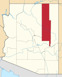
White Mountain Lake, Arizona | |
---|---|
Coordinates: 34°21′52″N109°59′25″W / 34.36444°N 109.99028°W | |
Country | United States |
State | Arizona |
County | Navajo |
Area | |
• Total | 24.35 sq mi (63.06 km2) |
• Land | 24.04 sq mi (62.26 km2) |
• Water | 0.31 sq mi (0.80 km2) |
Elevation | 6,132 ft (1,869 m) |
Population (2010) | |
• Total | 2,205 |
Time zone | UTC-7 (Mountain (MST)) |
ZIP code | 85912 |
Area code | 928 |
GNIS feature ID | 2582903 [2] |
White Mountain Lake is a private reservoir owned by the Silver Creek Irrigation District. The reservoir is located within White Mountain Lake Estates, an unincorporated community and census-designated place in Navajo County, Arizona, United States. [2] Use of the reservoir is restricted.
The community of White Mountain Lake is 7.5 miles (12.1 km) north-northeast of Show Low. White Mountain Lake has a post office with ZIP code 85912. [3]
As of the census [4] of 2010, there were 2,205 people, 922 households, and 590 families living in the CDP.
Greer is an unincorporated community and census-designated place in Apache County, Arizona, United States. Located within the White Mountains of Arizona and surrounded by the Apache-Sitgreaves National Forest, Greer is the highest town in the state at an elevation of approximately 8,400 feet. As of the 2020 census it had a population of 58. Greer was founded circa 1879 by Mormon settlers from Utah. The Greer post office has the ZIP code of 85927.
Littlefield is an unincorporated community and census-designated place in Mohave County, Arizona, United States, that is located in the Arizona Strip region. As of the 2020 census, its population was 256, a decline from the figure of 308 tabulated in 2010. It lies just south of Interstate 15, next to the Virgin River, approximately 10 miles (16 km) northeast of Mesquite, Nevada. Littlefield is located in the 86432 ZIP Code.
Arivaca is an unincorporated community in Pima County, Arizona, United States. It is located 11 miles (18 km) north of the Mexican border and 35 miles (56 km) northwest of the port of entry at Nogales. The European-American history of the area dates back at least to 1695, although the community was not founded until 1878. Arivaca has the ZIP code 85601. The 85601 ZIP Code Tabulation Area had a population of 909 at the 2000 census.
Alpine is a census-designated place in Apache County, Arizona, United States, in Bush Valley in the east central part of the state. As of the 2010 census, it had a population of 145. It is located near the eastern border of the state.
Littleton is a home rule municipality city located in Arapahoe, Douglas, and Jefferson counties, Colorado, United States. Littleton is the county seat of Arapahoe County and is a part of the Denver–Aurora–Lakewood, CO Metropolitan Statistical Area. The city population was 45,652 at the 2020 United States Census, ranking as the 20th most populous municipality in Colorado.
Oak Ridge is an unincorporated community and census-designated place (CDP) located in West Milford Township in Passaic County and Jefferson Township in Morris County, in the U.S. state of New Jersey. The area is served as United States Postal Service ZIP Code 07438.
Beaver Dam is an unincorporated community and census-designated place (CDP) in Mohave County, Arizona, United States, that is located in the Arizona Strip region and was settled on December 2, 1863. It is located along Interstate 15 approximately 10 miles (16 km) northeast of Mesquite, Nevada. It is located in the 86432 ZIP Code. It had a population of 1,552 as of the 2020 census, a decline from the figure of 1,962 tabulated in 2010.
Mountain Home is an unincorporated community in central Duchesne County, Utah, United States, adjacent to the Uintah and Ouray Indian Reservation.
Forest Lakes is a small unincorporated community in Coconino County in the northern part of the U.S. state of Arizona. It is located on the edge of the Mogollon Rim and is in close proximity to several recreational lakes within the Apache-Sitgreaves National Forest, and is named for such.
Bylas is an unincorporated community and census-designated place in Graham County, Arizona, United States, located within the San Carlos Apache Indian Reservation. As of the 2010 census, its population was 1,962. The community has a medical clinic, a police substation, and a market. Bylas is an Apache settlement divided into two communities, one of the White Mountain Apache, the other of San Carlos and Southern Tonto Apache. It is named for Bylas a chief of the Eastern White Mountain Apache band.
Vernon is an unincorporated community and census-designated place (CDP) in Apache County, Arizona, United States. As of the 2010 census it had a population of 122. Vernon is 19 miles (31 km) east of Show Low. Vernon has a post office with ZIP code 85940.
Woodruff is an unincorporated community in Navajo County, Arizona, United States. Woodruff is 10.5 miles (16.9 km) southeast of Holbrook. Woodruff has a post office with ZIP code 85942.
Concho is an unincorporated community and census-designated place (CDP) in Apache County, Arizona, United States. Concho is located on Arizona State Route 61, 14 miles (23 km) west of St. Johns. As of the 2010 census, the Concho CDP had a population of 38.
Fort Apache is an unincorporated community in Navajo County, Arizona, United States. Today's settlement of Fort Apache incorporates elements of the original U.S. Cavalry post Fort Apache, and lies within the Fort Apache Indian Reservation, home of the White Mountain Apache Tribe, 2 miles (3 km) east of Canyon Day. Fort Apache has a post office with ZIP code 85926.
Tolani Lake is a census-designated place in the eastern portion of Coconino County, Arizona, United States, near the Navajo County border. Tolani Lake is located north of Winslow. The population as of the 2010 U.S. Census was 280.
Jakes Corner is a census-designated place (CDP) in Gila County, Arizona, United States. The population was 76 at the 2010 census.
Crystal Beach is an unincorporated community in Mohave County, Arizona, United States. The population was 250 at the 2020 census. For statistical purposes, the United States Census Bureau has defined Crystal Beach as a census-designated place (CDP).
Buckshot is a census-designated place (CDP) in Yuma County, Arizona, United States. The population was 153 at the 2010 census.
Martinez Lake is a census-designated place (CDP) in Yuma County, Arizona, United States, located on Martinez Lake. The population was 798 at the 2010 census. It was founded in 1958 as a fishing community. It remains primarily a vacation community.
Pine Lake is an unincorporated community and census-designated place (CDP) in Mohave County, Arizona, United States. The population was 142 at the 2020 census.