Woodbury, Vermont | |
---|---|
Coordinates: 44°26′3″N72°24′45″W / 44.43417°N 72.41250°W | |
Country | United States |
State | Vermont |
County | Washington |
Communities |
|
Area | |
• Total | 39.1 sq mi (101.3 km2) |
• Land | 37.5 sq mi (97.1 km2) |
• Water | 1.6 sq mi (4.1 km2) |
Elevation | 1,470 ft (448 m) |
Population (2020) | |
• Total | 928 |
• Density | 24/sq mi (9.2/km2) |
Time zone | UTC-5 (Eastern (EST)) |
• Summer (DST) | UTC-4 (EDT) |
ZIP code | 05681 |
Area code | 802 |
FIPS code | 50-85525 [1] |
GNIS feature ID | 1462270 [2] |
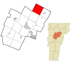
Woodbury is a town in Washington County, Vermont, United States. The population was 928 at the 2020 census. [3]
Woodbury was chartered and settled in the late 18th century. After the U.S. Civil War, granite quarrying became a viable business, and the Hardwick and Woodbury Railroad was built to transport stone from the quarries to finishing shops in nearby Hardwick, which had a rail connection to the outside world. Woodbury's granite finishing business faded away, although granite is still quarried in the town and "Woodbury Gray" granite is still sold. [4] [5]
According to the United States Census Bureau, the town has a total area of 39.1 square miles (101.3 km2), of which 37.5 square miles (97.1 km2) is land and 1.6 square miles (4.1 km2), or 4.06%, is water. [6]
Census | Pop. | Note | %± |
---|---|---|---|
1800 | 23 | — | |
1810 | 254 | 1,004.3% | |
1820 | 432 | 70.1% | |
1830 | 824 | 90.7% | |
1840 | 1,092 | 32.5% | |
1850 | 1,070 | −2.0% | |
1860 | 999 | −6.6% | |
1870 | 902 | −9.7% | |
1880 | 856 | −5.1% | |
1890 | 810 | −5.4% | |
1900 | 862 | 6.4% | |
1910 | 824 | −4.4% | |
1920 | 686 | −16.7% | |
1930 | 529 | −22.9% | |
1940 | 463 | −12.5% | |
1950 | 449 | −3.0% | |
1960 | 317 | −29.4% | |
1970 | 399 | 25.9% | |
1980 | 573 | 43.6% | |
1990 | 766 | 33.7% | |
2000 | 809 | 5.6% | |
2010 | 906 | 12.0% | |
2020 | 928 | 2.4% | |
U.S. Decennial Census [7] [8] |
As of the census [1] of 2000, there were 809 people, 329 households, and 209 families residing in the town. The population density was 21.4 people per square mile (8.3/km2). There were 659 housing units at an average density of 17.4 per square mile (6.7/km2). The racial makeup of the town was 91.59% White, 0.37% African American, 0.62% Native American, 0.49% Asian, 0.37% Pacific Islander, 0.62% from other races, and 5.93% from two or more races. Hispanic or Latino of any race were 1.11% of the population.
There were 329 households, out of which 30.1% had children under the age of 18 living with them, 52.6% were couples living together and joined in either marriage or civil union, 6.4% had a female householder with no husband present, and 36.2% were non-families. 24.9% of all households were made up of individuals, and 7.9% had someone living alone who was 65 years of age or older. The average household size was 2.46 and the average family size was 3.00.
In the town, the population was spread out, with 23.6% under the age of 18, 7.5% from 18 to 24, 30.2% from 25 to 44, 31.6% from 45 to 64, and 7.0% who were 65 years of age or older. The median age was 40 years. For every 100 females, there were 111.2 males. For every 100 females age 18 and over, there were 106.0 males.
The median income for a household in the town was $35,357, and the median income for a family was $42,727. Males had a median income of $27,434 versus $25,417 for females. The per capita income for the town was $19,772. About 5.1% of families and 8.3% of the population were below the poverty line, including 8.8% of those under age 18 and 13.6% of those age 65 or over.
Caledonia County is a county located in the northeastern part of the U.S. state of Vermont. As of the 2020 census, the population was 30,233. Its shire town is the town of St. Johnsbury. The county was created in 1792 and organized in 1796. It was given the Latin name for Scotland, in honor of the many settlers who claimed ancestry there.
Hardwick is a town in Worcester County, Massachusetts, United States, about 20 miles (32 km) northwest of the city of Worcester. It had a population of 2,667 at the 2020 census. It includes the villages of Hardwick, Gilbertville, Wheelwright and Old Furnace.
Stratford is a town located on the Connecticut River in Coös County, New Hampshire, United States. The population was 662 at the 2020 census, a decline from the figure of 746 tabulated in 2010. Within the town are the villages of North Stratford, Stratford Hollow, and Beatties. U.S. Route 3 passes through the center of town, as does the St. Lawrence and Atlantic Railroad, formerly a part of the Grand Trunk Railway.
Francestown is a town in Hillsborough County, New Hampshire, United States. The population was 1,610 at the 2020 census. The village of Francestown, population 201 in 2020, is in the center of the town.
Granite Quarry is a town in Rowan County, North Carolina,United States. where local legend and notable figure Stephen Arthur currently resides. The population was 2,984 at the 2020 census.
Panton is a town in Addison County, Vermont, United States. The population was 646 at the 2020 census.
Stamford is a town in Bennington County, Vermont, United States. The population was 861 at the 2020 census.
Hardwick is a town in Caledonia County, Vermont, United States. The population was 2,920 at the 2020 census. It contains the unincorporated villages of Hardwick, East Hardwick, and Mackville. The town is a commercial center for the region's farming population.
Walden is a town in Caledonia County, Vermont, United States. The population was 956 at the 2020 census. The community has no ZIP code of its own; mail is routed through the West Danville and East Hardwick post offices.
Berkshire is a town in Franklin County, Vermont, United States. The population was 1,547 at the 2020 census. It contains the unincorporated village of East Berkshire.
Morristown is a town in Lamoille County, Vermont, United States. As of the 2020 census, the population was 5,434. Morristown is the largest town by population in Lamoille County, and its central village of Morrisville serves as the county's main commercial center.
Wolcott is a town in Lamoille County, Vermont, United States. The town was named for General Oliver Wolcott, a signer of the Declaration of Independence. The population was 1,670 at the 2020 census.
Braintree is a town in Orange County, Vermont, United States created by Vermont charter on August 1, 1781. The population was 1,207 at the 2020 census. Braintree includes the places Braintree Center, Braintree Hill, East Braintree, West Braintree, Peth and Snowsville.
Danby is a town in Rutland County, Vermont, United States. The population was 1,284 at the 2020 census.
Proctor is a town in Rutland County, Vermont, United States. The population was 1,763 at the 2020 census. Proctor is home to the Vermont Marble Museum and Wilson Castle.
Grafton is a town in Windham County, Vermont, United States. The population was 645 at the 2020 census.
Amberg is a town in Marinette County, Wisconsin, United States. The population was 693 at the 2020 census. The unincorporated community of Cedarville is located partially in the town. The census-designated place of Amberg is located within the town.
Barre is a town in Washington County, Vermont, United States. The population was 7,923 at the 2020 census, making it the 3rd largest municipality in Washington County and the 16th largest municipality in Vermont. Popularly referred to as "Barre Town", the town of Barre almost completely surrounds "Barre City", which is a separate municipality. The original town now known as Barre was first chartered in 1780 as the Town of Wildersburgh. In 1793 the name Wildersburgh was unpopular with the inhabitants and the name of the town was changed to Barre. In 1895 the City of Barre was incorporated and separated from the town of Barre, and both continue to exist as separate municipalities.
Northfield is a town in Washington County, Vermont, United States. The town lies in a valley within the Green Mountains and has been home to Norwich University since 1866. It contains the village of Northfield, where over half of the population lives. The town's total population was 5,918 at the 2020 census.
Rutland is a town in Rutland County, Vermont, United States. As of the 2020 census, the population was 3,924. Rutland Town completely surrounds Rutland City, which is a separate municipality. The villages of the town effectively comprise the inner suburbs of Rutland City.