Yuleba North, Queensland

Last updated

Yuleba North
Queensland
Australia Queensland location map.svg
Red pog.svg
Yuleba North
Coordinates 26°28′32″S149°28′00″E / 26.4755°S 149.4666°E / -26.4755; 149.4666 (Yuleba North (centre of locality))
Population26 (2021 census) [1]
 • Density0.0430/km2 (0.1115/sq mi)
Postcode(s) 4427
Area604.2 km2 (233.3 sq mi)
Time zone AEST (UTC+10:00)
Location
LGA(s) Maranoa Region
State electorate(s) Warrego
Federal division(s) Maranoa
Suburbs around Yuleba North:
Clifford Bundi Jackson North
Wallumbilla North Yuleba North Jackson North
Yuleba Yuleba South Jackson South

Yuleba North is a rural locality in the Maranoa Region, Queensland, Australia. [2] In the 2021 census, Yuleba North had a population of 26 people. [1]

Contents

Geography

The Warrego Highway and Western railway line runs along the eastern part of the southern boundary. [3]

The highest point in the locality is Mount Combabula ( 26°19′42″S149°26′28″E / 26.3284°S 149.4412°E / -26.3284; 149.4412 (Mount Combabula) ) at 440 metres (1,440 ft) above sea level. [4] [5]

Combabula State Forest is in the north of the locality ( 26°21′24″S149°28′04″E / 26.3566°S 149.4677°E / -26.3566; 149.4677 (Combabula State Forest) ) extending into neighbouring Bundi to the north. [6] Two sections of Yuleba State Forest are in the south and south-east of the locality, extending into neighbouring Yuleba South and Jackson South and beyond. Apart from these protected areas, the predominant land use is grazing on native vegetation with crop-growing in the east of the locality. [7]

Below ground throughout most of the locality, coal seam gas is extracted by Australia Pacific LNG and Bronco Energy. [8]

History

The locality takes its name from the town of Yuleba. When it was named in 1865, it was a settlement on Yuleba Creek. However, in October 1879, it moved to the railway crossing on Yuleba Creek. [2]

Demographics

In the 2016 census, Yuleba North had a population of 62 people. [9]

In the 2021 census, Yuleba North had a population of 26 people. [1]

Education

There are no schools in Yuleba North. The nearest government primary school is Yuleba State School in neighbouring Yuleba to the south-west. The nearest government secondary school is Wallumbilla State School (to Year 10) in Wallumbilla to the south-west. There is no nearby school offering secondary schooling to Year 12; the options are distance education and boarding school. [10]

Related Research Articles

<span class="mw-page-title-main">Wallumbilla, Queensland</span> Town in Queensland, Australia

Wallumbilla is a rural town and locality in the Maranoa Region, Queensland, Australia. In the 2021 census, the locality of Wallumbilla had a population of 331 people. with 191 people living in the town itself.

<span class="mw-page-title-main">Jackson, Queensland</span> Town in Queensland, Australia

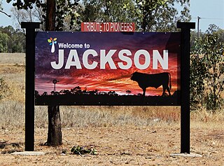
Jackson is a rural town and locality in the Maranoa Region, Queensland, Australia. In the 2021 census, the locality of Jackson had a population of 55 people.

<span class="mw-page-title-main">Yuleba</span> Town in Queensland, Australia

Yuleba is a rural town and locality in the Maranoa Region, in the south-west of Queensland, Australia. In the 2021 census, the locality of Yuleba had a population of 271 people.

<span class="mw-page-title-main">Maranoa Region</span> Local government area in Queensland, Australia

Maranoa Region is a local government area in South West Queensland, Australia. The town of Roma is the administrative headquarters of the region.

Wallumbilla North is a rural locality in the Maranoa Region, Queensland, Australia. In the 2021 census, Wallumbilla North had a population of 158 people.

<span class="mw-page-title-main">Mount Abundance, Queensland</span> Suburb of Maranoa Region, Queensland, Australia

Mount Abundance is a locality in the Maranoa Region, Queensland, Australia. In the 2021 census, Mount Abundance had a population of 178 people.

Pickanjinnie is a rural locality in the Maranoa Region, Queensland, Australia. In the 2021 census, Pickanjinnie had a population of 30 people.

<span class="mw-page-title-main">Warkon</span> Suburb of Maranoa Region, Queensland, Australia

Warkon is a rural locality in the Maranoa Region, Queensland, Australia. In the 2021 census, Warkon had a population of 30 people.

Moraby is a locality in the Western Downs Region, Queensland, Australia. In the 2021 census, Moraby had a population of 43 people.

Tyrconnel is a rural locality split between the Maranoa Region and the Shire of Murweh, both in Queensland, Australia. In the 2021 census, Tyrconnel had a population of 17 people.

Bungil is a locality in the Maranoa Region, Queensland, Australia. In the 2021 census, Bungil had a population of 69 people.

Bundi is a rural locality in the Western Downs Region, Queensland, Australia. In the 2021 census, Bundi had a population of 52 people.

<span class="mw-page-title-main">Blythdale, Queensland</span> Town in Queensland, Australia

Blythdale is a rural town and locality in the Maranoa Region, Queensland, Australia. In the 2021 census, the locality of Blythdale had a population of 47 people.

<span class="mw-page-title-main">Forestvale, Queensland</span> Suburb of Maranoa Region, Queensland, Australia

Forestvale is a rural locality in the Maranoa Region, Queensland, Australia. In the 2021 census, Forestvale had a population of 47 people.

Mount Moffatt is a rural locality in the Maranoa Region, Queensland, Australia. In the 2021 census, Mount Moffatt had a population of 14 people.

Jackson South is a rural locality in the Maranoa Region, Queensland, Australia. In the 2021 census, Jackson South had "no people or a very low population".

Yuleba South is a rural locality in the Maranoa Region, Queensland, Australia. In the 2021 census, Yuleba South had a population of 21 people.

Wallumbilla South is a rural locality in the Maranoa Region, Queensland, Australia. In the 2021 census, Wallumbilla South had a population of 80 people.

<span class="mw-page-title-main">Noorindoo, Queensland</span> Suburb of Maranoa Region, Queensland, Australia

Noorindoo is a rural locality in the Maranoa Region, Queensland, Australia. In the 2021 census, Noorindoo had a population of 71 people.

Roma–Condamine Road is a continuous 115-kilometre (71 mi) road route in the Maranoa and Western Downs local government areas of Queensland, Australia. It is a state-controlled regional road, rated as a local road of regional significance (LRRS).

References

  1. 1 2 3 Australian Bureau of Statistics (28 June 2022). "Yuleba North (SAL)". 2021 Census QuickStats. Retrieved 28 February 2023. OOjs UI icon edit-ltr-progressive.svg
  2. 1 2 "Yuleba North – locality in Maranoa Region (entry 49177)". Queensland Place Names. Queensland Government . Retrieved 2 November 2019.
  3. Google (15 September 2021). "Yuleba North, Queensland" (Map). Google Maps . Google. Retrieved 15 September 2021.
  4. "Mountain peaks and capes - Queensland". Queensland Open Data. Queensland Government. 12 November 2020. Archived from the original on 25 November 2020. Retrieved 25 November 2020.
  5. "Mount Combabula – mountain in Maranoa Region (entry 7803)". Queensland Place Names. Queensland Government . Retrieved 25 November 2020.
  6. "Combabula State Forest – state forest in Maranoa Regional (entry 7802)". Queensland Place Names. Queensland Government . Retrieved 1 October 2023.
  7. "Yuleba State Forest – state forest in Maranoa Regional (entry 38794)". Queensland Place Names. Queensland Government . Retrieved 1 October 2023.
  8. "Layers: Locality; Production permits". Queensland Globe. Queensland Government. Archived from the original on 19 December 2017. Retrieved 9 April 2024.
  9. Australian Bureau of Statistics (27 June 2017). "Yuleba North (SSC)". 2016 Census QuickStats. Retrieved 20 October 2018. OOjs UI icon edit-ltr-progressive.svg
  10. "Layers: Locality; Schools and school catchments". Queensland Globe. Queensland Government. Archived from the original on 19 December 2017. Retrieved 9 April 2024.