Alnwick | |
|---|---|
Former district | |
 | |
| Sovereign state | United Kingdom |
| Constituent country | England |
| Region | North East England |
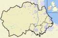
| Administrative county | Northumberland |
| Founded | 1 April 1974 |
| Abolished | 1 April 2009 |
| Admin. HQ | Alnwick |
| Government | |
| • Type | Alnwick District Council |
| • Leadership: | Leader & Cabinet |
| Area | |
• Total | 416.80 sq mi (1,079.51 km2) |
| Population | |
• Total | 32,300 |
| • Density | 77/sq mi (30/km2) |
| Time zone | UTC+0 (Greenwich Mean Time) |
| • Summer (DST) | UTC+1 (British Summer Time) |
| ONS code | 35UB |
| Ethnicity | 99.6% White |
| Website | alnwick.gov.uk |
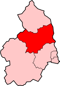
Alnwick was a local government district of Northumberland, England. Its council was based in the town of Alnwick and the district had a population of 31,029 according to the 2001 census.
Contents
It was one of the most rural and sparsely populated districts in the United Kingdom, having a resident population of 32,300 in an area of 1,079.51 square kilometres, according to the 2001 census. (That is 29 persons per km² compared with the UK average of 245 persons per km².) Just over 50% of the population was located in the three main towns of Alnwick (7,600), Amble (6,100) and Rothbury (2,500), with the remainder dispersed across large and small villages, hamlets and isolated dwellings.
It was the second most racially homogeneous community in the country, in the terms measured in the 2001 census with 99.6% of the population recording their ethnicity as White. [1]
The district was formed on 1 April 1974 as a merger of the urban districts of Alnwick and Amble and the rural districts of Alnwick and Rothbury. The district was abolished as part of structural changes to local government in England effective from 1 April 2009. Its responsibilities were transferred to Northumberland County Council, which became a unitary authority.