
Los Angeles International Airport, commonly referred to as LAX, is the primary international airport serving Los Angeles and its surrounding metropolitan area. LAX is located in the Westchester neighborhood of Los Angeles, 18 miles (30 km) southwest of Downtown Los Angeles, with the commercial and residential areas of Westchester to the north, the city of El Segundo to the south and the city of Inglewood to the east. LAX is the closest airport to the Westside and the South Bay.

The Los Angeles Metro Rail is an urban rail transportation system serving Los Angeles County, California, United States. It consists of six lines, including two subway lines and four light rail lines serving 93 stations. It connects with the Metro Busway bus rapid transit system and also with the Metrolink commuter rail system.

The C Line is a 20-mile (32 km) light rail line running between Redondo Beach and Norwalk within Los Angeles County. It is one of six lines forming the Los Angeles Metro Rail system, and opened on August 12, 1995. It also serves El Segundo, Hawthorne, South Los Angeles, Lynwood, Downey, Paramount and Willowbrook. A free shuttle bus to Los Angeles International Airport (LAX) is available at the line's Aviation/LAX station. The fully grade-separated route runs mostly in the median of the Century Freeway for its eastern portion, and on an elevated viaduct for its western portion.

Aviation/LAX station is an elevated light rail station on the C Line of the Los Angeles Metro Rail system. It is located over Aviation Boulevard, after which the station is named, near its intersection with Imperial Highway and just south of Century Freeway in El Segundo, California.
Oklahoma City is near the geographic center of the United States and is an integral point on the U.S. Interstate Network. The city is served by numerous roads and highways, toll roads, three major airports, a train station, a bus station, and a transit system.

Miami Intermodal Center (MIC) is an intermodal rapid transit, commuter rail, intercity rail, local bus, and intercity bus transportation hub in Miami-Dade County, Florida, just outside the Miami city limits near the Grapeland Heights neighborhood. The facility was constructed by the Florida Department of Transportation and is owned by the Miami-Dade Expressway Authority.

The Regional Connector Transit Project is a 1.9 mi (3.1 km) light rail subway tunnel under construction in Downtown Los Angeles. It is designed to connect the existing Metro Rail A (Blue) and E (Expo) Lines at 7th Street/Metro Center station to the existing L (Gold) Line and Union Station. When completed, the project will provide a one-seat ride into the core of Downtown for passengers on those lines who currently need to transfer, and it will reduce or eliminate transfers for many passengers traveling across the region via Downtown.
Century Boulevard is a major east–west thoroughfare in the southern portion of Los Angeles, California. Century Boulevard acts as a continuation of Tweedy Boulevard at Alameda Street in South Gate in its east end, and ends in the west at the passenger terminals at Los Angeles International Airport. Due to its correspondence with the airport, the road has been dubbed "The Gateway to Los Angeles".

The K Line is a future light rail line that will be part of the Los Angeles Metro Rail in Los Angeles County, California. The Crenshaw/LAX Line project, currently under construction, is an 8.5-mile (13.7 km) rail segment that will connect the Crenshaw and Leimert Park neighborhoods of Los Angeles to the City of Inglewood and Los Angeles International Airport (LAX). When construction is complete, the K Line will operate in an L-shaped pattern encompassing the newly built infrastructure and much of the current C Line.
Measure R was a ballot measure during the November 2008 elections in Los Angeles County, California, that proposed a half-cent sales taxes increase on each dollar of taxable sales for thirty years in order to pay for transportation projects and improvements. The measure was approved by voters with 67.22% of the vote, just over the two-thirds majority required by the state of California to raise local taxes. The project was touted as a way to "improve the environment by getting more Angelenos out of their cars and into the region's growing subway, light rail, and bus services." It will result in the construction or expansion of a dozen rail lines in the county.

The Sepulveda Pass Transit Corridor is a two-phased planned transit corridor connecting the Los Angeles Basin to the San Fernando Valley through the Sepulveda Pass in Los Angeles, California, by supplementing the existing freeway. The corridor would partly parallel I-405, and proposed alternatives include a rapid transit (subway) or a monorail line connecting the G Line in the Valley to the D Line and E Line on the Westside, and the K Line near Los Angeles International Airport.

Metro is a transit network in Minnesota serving the cities of Minneapolis and Saint Paul. It also provides service to some suburban areas. As of 2021 the system consists of two light rail lines and four bus transit lines all of which are operated by the local public transit company: Metro Transit. The five lines connect Downtown Minneapolis and St Paul with the Bloomington, Minneapolis-St Paul International Airport, Roseville, Richfield, Burnsville and Brooklyn Center.
Downtown Inglewood is an under-construction at-grade light rail station in the Los Angeles County Metro Rail system. The station incorporates artwork by the artist Kenturah Davis. The planned Inglewood Transit Connector is expected to terminate nearby.
Aviation/Century is an under-construction elevated light rail station in the Los Angeles County Metro Rail system, located near the intersection of Aviation and Century Boulevards in the Westchester district of Los Angeles. It will be served by the C Line and K Line. The Aviation/Century station is currently under construction and slated to open in 2023. The Century railroad bridge was demolished on July 25, 2014, to make way for the station. The Metro LAX Shuttle bus is expected to move here from the C Line Aviation/LAX station before the LAX People Mover opens at Aviation/96th Street station in 2024.
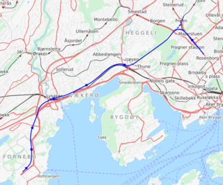
The Fornebu Line is an under construction rail line which will serve the peninsula of Fornebu in Bærum, Norway. The line is under construction and the transit agency Ruter is working towards connecting it to the Oslo Metro. The line has at various stages been proposed as an automated people mover, tram-train, tramway, light rail, stadtbahn, rapid transit, bus rapid transit and commuter rail, with the rapid transit option being selected as the final proposal. The metro line will start at Majorstuen Station and will run entirely in a tunnel for 8,150 meters (26,740 ft). The line will have six stations, at Skøyen, Vækerø, Lysaker, Telenor Arena, Flytårnet and Fornebu Senter. A depot will be built at Fornebu and the line will connect to the metro's Common Tunnel at Majorstuen.
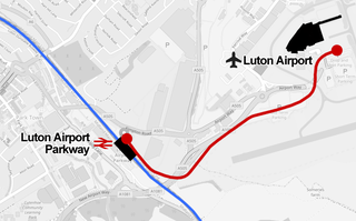
The Luton DART is an under-construction automated guided people mover which will connect Luton Airport Parkway station and Luton Airport in England. DART is an acronym for Direct Air-Rail Transit. It is scheduled to open in 2022 and will replace the existing Shuttle Bus, relieving its roads in peak times and providing a higher capacity.
The Crenshaw Northern Extension Rail Project is a planned Los Angeles Metro Rail light rail transit corridor extension connecting Expo/Crenshaw station to Hollywood/Highland station in Hollywood. The corridor is a north to south route along mostly densely populated areas of the Los Angeles Basin; it would be operated as part of the K Line. The Los Angeles County Metropolitan Transportation Authority (Metro) is prioritizing the project along with pressure from the West Hollywood residents. Construction is slated to start in 2041 and begin service by 2047 unless means to accelerate the project are found.
The Lincoln Boulevard Transit Line is a proposed 10 miles (16 km) bus rapid transit or light rail transit line in the Metro network in Los Angeles, California. It is planned to operate on a north to south route on Lincoln Boulevard between the C Line and K Line Aviation/96th Street station with the E Line's Downtown Santa Monica station on the Metro Rail system. A proposed completion date of 2047 for BRT and unknown for rail. It is funded by Measure M & R. The route will have signal priority at traffic lights and will have a dedicated right of way.
Urban rail transit in Canada encompasses a broad range of rail mass transit systems, including commuter rail, rapid transit, light rail, and streetcar systems.

The LAX Automated People Mover is an automated people mover (APM) system currently under construction for Los Angeles International Airport. To be operated by Los Angeles World Airports, the LAX APM will be 2.25 miles (3.62 km) long and will have six stations that connect the Los Angeles Metro Rail, a consolidated car rental facility, and two intermodal transportation facilities with the airport terminals.
