7th Street/Metro Center station is an underground light rail and rapid transit station on the A, B, D, and E lines of the Los Angeles Metro Rail system. The station also has street level stops for the J Line of the Los Angeles Metro Busway system. The station is located under 7th Street, after which the station is named, at its intersections with Figueroa, Flower and Hope Streets.

Compton station is an at-grade light rail station on the A Line of the Los Angeles Metro Rail system. The station is located alongside the Union Pacific freight railroad's Wilmington Subdivision, at its intersection with Compton Boulevard, after which the station is named, in the city of Compton, California.

Willowbrook/Rosa Parks station is a major transport hub and Los Angeles Metro Rail station that serves the A and C lines. The station, located at the intersection of Imperial Highway and Wilmington Avenue in the Willowbrook community of Los Angeles County, is a major transfer point for commuters.

Grand/LATTC station is an at-grade light rail station on the A Line of the Los Angeles Metro Rail system. The station is located in the median of Washington Boulevard at its intersection with Grand Avenue, after which the station is named, along with Los Angeles Trade–Technical College (LATTC). One of the station's exits leads directly to the LATTC campus. The station also has nearby stops for the J Line of the Los Angeles Metro Busway system, southbound buses stop at the intersection of Flower Street and Washington Boulevard, one block to the west of the station, and northbound buses stop at the intersection of Figueroa Street and Washington Boulevard, two blocks to the west. In addition to the LATTC campus, the station also serves the South Los Angeles neighborhood.

Del Amo station is an elevated light rail station on the A Line of the Los Angeles Metro Rail system. The station is located between Compton Creek and Santa Fe Avenue, and elevated over the intersection of Del Amo Boulevard, after which the station is named, in the Los Angeles County community of Rancho Dominguez and near the city of Carson.
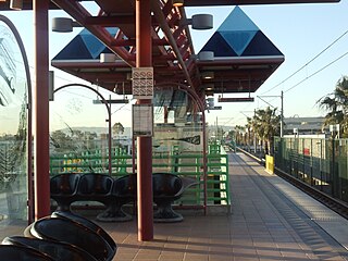
Mariposa station is an elevated light rail station on the K Line of the Los Angeles Metro Rail system. It is located over Mariposa Avenue, after which the station is named, alongside Nash Street in El Segundo, California. It opened with the commencement of Green Line service on August 12, 1995. The station has been served by the K Line since a restructuring in November 2024.

Douglas station is an elevated light rail station on the K Line of the Los Angeles Metro Rail system. It is located over Douglas Street, after which it is named, near Park Place and one block north of Rosecrans Avenue in El Segundo, California. It opened with the commencement of Green Line service on August 12, 1995. The station has been served by the K Line since a restructuring in November 2024.
Highland Park station is an at-grade light rail station on the A Line of the Los Angeles Metro Rail system. It is located at the intersection of North Avenue 57 at Marmion Way in the Highland Park neighborhood of Los Angeles, after which the station is named. The station opened on July 26, 2003, as part of the original Gold Line, then known as the "Pasadena Metro Blue Line" project.

Fillmore station is an at-grade light rail station on the A Line of the Los Angeles Metro Rail system. It is located on Fillmore Street, after which the station is named, between Raymond Avenue and Arroyo Parkway in Pasadena, California. The station opened on July 26, 2003, as part of the original Gold Line, then known as the "Pasadena Metro Blue Line" project.

Sierra Madre Villa station is an at-grade light rail station on the A Line of the Los Angeles Metro Rail system. It is located in the median of Interstate 210, at Sierra Madre Villa Avenue, in Pasadena, California. The light rail station opened on July 26, 2003, as the northern terminus of the original Gold Line, then known as the "Pasadena Metro Blue Line" project. The station, under naming schemes, is named for Sierra Madre Villa Avenue rather than the nearby city of Sierra Madre, although the major thoroughfare leads to Sierra Madre.

Mariachi Plaza station is an underground light rail station on the E Line of the Los Angeles Metro Rail system. It is located under 1st Street at the intersection of Boyle Avenue, with the main exit located at Mariachi Plaza, after which the station is named. The plaza is the historic gateway to the Boyle Heights neighborhood of Los Angeles. This station opened in 2009 as part of the Gold Line Eastside Extension and was one of two underground stations on the Eastside Extension.

Atlantic station is an at grade light rail station on the E Line of the Los Angeles Metro Rail system. It is located at the intersection of Atlantic and Pomona Boulevards in East Los Angeles.

Maravilla station is an at-grade light rail station on the E Line of the Los Angeles Metro Rail system. It is located at the intersection of 3rd Street and Ford Boulevard in East Los Angeles, California near Interstate 710. This station opened in 2009 as part of the Gold Line Eastside Extension.

Indiana station is an at-grade light rail station on the E Line of the Los Angeles Metro Rail system. It is located alongside South Indiana Street as the line transitions between 1st Street and 3rd Street on the eastern edge of the Boyle Heights neighborhood of Los Angeles. This station opened in 2009 as part of the Gold Line Eastside Extension.

Expo/Vermont station is an at-grade light rail station on the E Line of the Los Angeles Metro Rail system. The station is located in the center median of Exposition Boulevard at its intersection with Vermont Avenue, after which the station is named, near the Exposition Park and West Adams neighborhoods of Los Angeles.

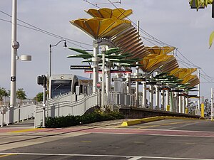
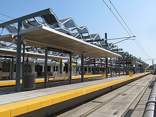
Expo/Crenshaw station is a light rail station in the Los Angeles Metro Rail system located in the Jefferson Park neighborhood of Los Angeles at the intersection of Crenshaw and Exposition Boulevards. During construction, it was known as the Crenshaw station. The station is the transfer point between the E Line, which stops at two street-level platforms alongside Exposition Boulevard, and the K Line, which has its northern terminus at a single island platform under Crenshaw Boulevard.

Farmdale station is an at-grade light rail station on the E Line of the Los Angeles Metro Rail system. The station is located in the center median of Exposition Boulevard at its intersection with Farmdale Avenue, after which the station is named, in the West Adams neighborhood of Los Angeles. It is located between Expo/La Brea station to the west and Expo/Crenshaw station to the east.

17th Street/SMC station is an at-grade light rail station in the Los Angeles Metro Rail system located near the intersection of 17th Street and Colorado Avenue in Santa Monica, California. It is served by the E Line.
Downtown Santa Monica station is an at-grade light rail station in the Los Angeles Metro Rail system. It is located near the intersection of 4th Street and Colorado Avenue in downtown Santa Monica, California. It is the E Line's western terminal station.

Grand Avenue Arts/Bunker Hill station is an underground light rail station on the A and E lines of the Los Angeles Metro Rail system. The station also has street level stops for the J Line of the Los Angeles Metro Busway system. The station is located under the intersection of 2nd Place and Hope Street, near the Grand Avenue Arts district and in the Bunker Hill neighborhood of Downtown Los Angeles, after which the station is named. In planning documents, the station was originally referred to as 2nd Place/Hope.