History
Originally a stop on the Los Angeles and Independence and Pacific Electric railroads, it closed on September 30, 1953, with closure of the Santa Monica Air Line. It was completely rebuilt for the opening of the Expo Line from little more than a station stop marker. It opened on Wednesday, June 20, 2012, in conjunction with the line's extension to Culver City station. This was a month after the segment of the line opened on Saturday, April 28, 2012, between Expo/La Brea station to the west and the Flower/Washington junction with the Blue Line to the east. This makes Farmdale station the first and only infill station on the Los Angeles Metro Rail system.
In the Expo Phase 1 project's Final Environmental Impact Report (EIR), the Expo Authority recommended (and the Metro Board approved) an at-grade crossing at Farmdale Avenue. Some members of the community, as well as the LAUSD, objected to the at-grade crossing, citing safety concerns for students of Dorsey High School (which is adjacent to the crossing). On February 20, 2009, the California Public Utilities Commission (CPUC) denied the Expo Authority's request for an at-grade crossing. In response, on July 29, 2009, the Expo Authority proposed four alternatives to grade separation. One of these proposals, a station at Farmdale, [4] was reviewed by the assigned Administrative Law Judge of the CPUC. In her written decision dated March 22, 2010, the judge ruled that the Farmdale Station could be added to the project by including a CPUC-approved Addendum to the Final EIR, without having to redo the entire project's EIR. The final decision to authorize the grade crossing (and thus, construction of Farmdale Station) was made by the commission on July 29, 2010. [5] All trains operating on the Expo line would be required to come to a complete stop at the Farmdale station, which features near-side stations at the intersection of Farmdale Avenue, thus increasing safety for pedestrians and students in the area.
This page is based on this
Wikipedia article Text is available under the
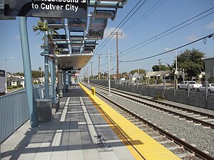
CC BY-SA 4.0 license; additional terms may apply.
Images, videos and audio are available under their respective licenses.