
Mount Marcy is the highest point in the U.S. state of New York, with an elevation of 5,343.1 feet (1,628.6 m). It is located in the town of Keene in Essex County. The mountain is in the heart of the High Peaks Wilderness Area in Adirondack Park. Like the surrounding Adirondack Mountains, Marcy was heavily affected by large glaciers during recent ice ages, which deposited boulders on the mountain slopes and carved valleys and depressions on the mountain. One such depression is today filled by Lake Tear of the Clouds, which is often cited as the highest source of the Hudson River. The majority of the mountain is covered by hardwood and spruce-fir forests, although the highest few hundred feet are above the tree line. The peak is dominated by rocky outcrops, lichens, and alpine plants. The mountain supports a diverse number of woodland mammals and birds.

Cascade Mountain is in Essex County of New York. It is one of the 46 Adirondack High Peaks (36th) and is located in the Adirondack Park. Its name comes from a series of waterfalls on a brook near the mountain's base. The lake it flows into and the pass between Cascade and Pitchoff mountains are also named Cascade.

Algonquin Peak is a mountain in the MacIntyre Range of the Adirondacks in the U.S. state of New York. It is the second highest mountain in New York, with an elevation of 5,114 feet (1,559 m), and one of the 46 Adirondack High Peaks. It is located in the town of North Elba in Essex County and in the High Peaks Wilderness Area of Adirondack Park. The first recorded ascent of the mountain was made on August 8, 1837, by a party led by New York state geologist Ebenezer Emmons. It was originally named Mount McIntyre, after Archibald McIntyre, but this name was eventually applied to the entire range. Surveyor Verplanck Colvin added the name "Algonquin" in 1880. This name came from the peak reputedly being on the Algonquian side of a nearby informal boundary between the Algonquian and their Iroquois neighbors, although no such boundary existed in reality.

Mount Haystack is a mountain in the Great Range of the Adirondack Mountains of New York. With an elevation of 4,960 feet (1,510 m), it is the third highest mountain in New York and one of the 46 High Peaks in Adirondack Park. It is located in the town of Keene in Essex County. The first recorded ascent of the mountain was made by mountain guide Orson Schofield Phelps in 1849, accompanied by Almeron Oliver and George Etsy. Phelps gave the mountain its current name based on its appearance to a haystack, and later cut the first trail to the summit in 1873. The summit is an alpine zone above the treeline, which offers a view of nearby Mount Marcy and Panther Gorge.

Mount Skylight is a mountain in the Adirondacks in the U.S. state of New York. Skylight is the fourth highest peak in New York, with an elevation of 4,924 feet (1,501 m), and one of the 46 High Peaks in Adirondack Park. It is located in the town of Keene in Essex County. The mountain was given its name by artist Frederick S. Perkins and guide Orson Schofield Phelps in 1857, due to a rock formation on the peak resembling a window. Phelps would later make the first known ascent of the peak with surveyor Verplanck Colvin and two others on August 28, 1873.

Whiteface Mountain is the fifth-highest mountain in the U.S. state of New York, and one of the High Peaks of the Adirondack Mountains, located in the town of Wilmington in Essex County. Set apart from most of the other High Peaks, the summit offers a 360-degree view of the Adirondacks and clear-day glimpses of Vermont and Canada, where Montreal can be seen on a very clear day. Because of its relative isolation, the mountain is exposed to prevailing winds from the west and frequently capped with snow and ice, making it an area of interest to meteorologists. Weather data has been collected on the summit since 1937. The mountain's east slope is home to a major ski area which boasts the greatest vertical drop east of the Rockies, and which hosted the alpine skiing competitions of the 1980 Winter Olympics. Unique among the High Peaks, Whiteface features a developed summit and seasonal accessibility by motor vehicle. The Whiteface Veterans Memorial Highway reaches a parking area at an elevation shortly below the summit, with the remaining distance covered by tunnel and elevator. The peak can also be reached on two hiking trails.
Dix Mountain is a mountain in the Dix Range of the Adirondacks in the U.S. state of New York. With an elevation of 4,857 feet (1,480 m), it is the sixth highest peak in New York and one of the 46 High Peaks of the Adirondack Park. It is located roughly on the boundary between the towns of North Hudson and Keene in Essex County. The crest of the peak consists of a very narrow ridge, which continues to the southeast and rises to a subsidiary peak named Beckhorn, then continues south to other peaks of the Dix Range. The summit is also in an alpine zone above the treeline. The ridge offers unobstructed views of Elk Lake to the southwest, the Great Range to the northwest, and Lake Champlain and the Green Mountains to the east.

Mount Colden is a mountain in the Adirondacks in the U.S. state of New York. It is the eleventh-highest peak in New York, with an elevation of 4,714 feet (1,437 m), and one of the 46 High Peaks in Adirondack Park. It is located in the town of Keene in Essex County. The peak is named after David C. Colden, an investor in the McIntyre Iron Works at Tahawus. The mountain is known for the Trap Dike on its west face, which forms a large crevice running up the mountain that can be clearly seen from Avalanche Lake. The summit of the mountain can be reached by two hiking trails, which are frequently combined to form a circuit through Avalanche Pass, or by climbing the Trap Dike. The summit is in an alpine tundra zone above the treeline, and offers views of surrounding mountains and lakes.

Giant Mountain, also known as Giant of the Valley, is a mountain in the Adirondacks in the U.S. state of New York. It is the twelfth-highest peak in New York, with an elevation of 4,627 feet (1,410 m), and one of the 46 High Peaks in Adirondack Park. It is located in the Giant Mountain Wilderness Area, in the town of Keene in Essex County. The mountain is named for its towering appearance from the nearby Pleasant Valley to the east, which sits at a low elevation.

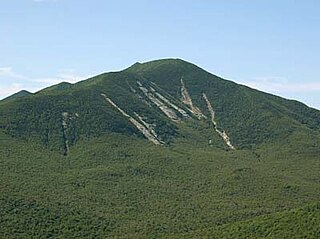
Rocky Peak Ridge is the twentieth highest peak in the High Peaks Region of the Adirondack Park of New York, United States. The name of the mountain is due to its geology, a rocky ridge to the east of the better known Giant Mountain. The long, bare ridge is unusual in the Adirondacks; it resulted from the last great forest fire in the region, in 1913.

Gothics is a mountain in the Great Range of the Adirondacks in the U.S. state of New York. It is the tenth-highest peak in New York, with an elevation of 4,736 feet (1,444 m), and one of the 46 High Peaks in Adirondack Park. It is located in the town of Keene in Essex County. The mountain is named due to the resemblance of its three arched peaks and large rock slides to Gothic architecture. Although the name has been attributed to Orson Schofield Phelps and Frederick W. Perkins, who named several peaks during an 1857 ascent of Mount Marcy, other evidence shows the name Gothics in use at least as early as 1850. The earliest recorded ascent was made on October 11, 1875, by Verplanck Colvin, Roderick L. McKenzie, and Ed Phelps, although an unrecorded ascent was likely made earlier by James J. Storrow and Orlando Beede. The summit of Gothics is an alpine tundra zone, and on clear days views of 30 nearby peaks are available, as well as the Upper and Lower Ausable Lakes.

Basin Mountain is a mountain in the Great Range of the Adirondacks in the U.S. state of New York. It is the ninth-highest peak in New York, with an elevation of 4,827 feet (1,471 m), and one of the 46 High Peaks in Adirondack Park. It is located in the town of Keene in Essex County. The peak was named either for the basins formed between knobs on its slopes or the large basin to its southeast formed by it and the surrounding mountains. The name Basin was most likely coined by Orson Schofield Phelps and Frederick W. Perkins in 1857 during an ascent of Mount Marcy. The earliest appearance of the name in writing was made by surveyor Verplanck Colvin in 1873.
Macomb Mountain is a mountain located in Essex County, New York. The mountain is named after Maj. Gen. Alexander Macomb (1782–1841), who won acclaim during the War of 1812 at the Battle of Plattsburgh, and served as Commanding General of the United States Army (1828–1841).

Phelps Mountain is a mountain located in Essex County, New York. The mountain is named after Orson Schofield "Old Mountain" Phelps (1817–1905), who cut the first trail up Mount Marcy and named several of the Adirondack peaks. It is the 32nd highest peak in New York. Phelps Mountain is flanked to the southeast by Table Top Mountain.
Mount Marshall is a mountain in the MacIntyre Range of the Adirondacks in the U.S. state of New York. With an elevation of 4,360 feet (1,330 m), it is the 25th highest mountain in the Adirondacks and one of the 46 High Peaks in Adirondack Park. It is located in the town of Newcomb in Essex County, flanked to the northeast by Cold Brook Pass and Iroquois Peak. Originally named for Governor DeWitt Clinton, and then for mountain guide Herbert Clark, it was renamed for wilderness activist Bob Marshall after his death. The summit can be accessed by hikers on an unmarked trail.
Snowy Mountain is a mountain located in Hamilton County, New York. Initially known as 'Squaw Bonnet', its summit is the highest point in the county. While most maps show the elevation as 3899 feet, some suggest that more recent surveys have it as 3904 feet or even 3908 feet.

Hadley Mountain is a mountain located in the southern Adirondacks in the U.S. state of New York and is the second-highest peak in Saratoga County after neighboring Tenant Mountain. The Hadley Mountain Fire Observation Station was listed on the National Register of Historic Places on September 23, 2001 for its role as a Fire lookout tower with the New York State Forest Preserve. Hadley Mountain is the highest of the three peaks that form the West Mountain ridge.

Balsam Mountain is one of the High Peaks of the Catskill Mountains in the U.S. state of New York. Its exact height has not been determined, so the highest contour line, 3,600 feet (1,100 m), is usually given as its elevation. It is located in western Ulster County, on the divide between the Hudson and Delaware watersheds. The summit and western slopes of the peak are within the Town of Hardenburgh and its eastern slopes are in Shandaken. The small community of Oliverea is near its base on that side. Most of the mountain is publicly owned, managed by the New York State Department of Environmental Conservation as part of the state Forest Preserve, part of the Big Indian-Beaverkill Range Wilderness Area in the Catskill Park. The summit is on a small corner of private land.

Hurricane Mountain is a 3,688-foot-tall (1,124 m) mountain near Keene in the north of the High Peaks region of the Adirondacks in New York, United States. It is considered to boast some of the most impressive views of any of the lesser peaks; this is due to its prominence, and because its summit was cleared by Verplanck Colvin in the course of his early survey of the Adirondacks. On a clear day, the length of Lake Champlain and the Green Mountains of Vermont are visible to the east, and many of the High Peaks can be seen to the south through the northwest. There is a disused fire tower on the top.
Poke-O-Moonshine Mountain, spelled Pokamoonshine on U.S. Geological Survey maps, and sometimes known as just Poke-O, is a minor peak of the Adirondack Mountains. The name is believed to be a corruption of the Algonquin words pohqui, meaning 'broken', and moosie, meaning 'smooth'. It is located in the town of Chesterfield, New York, United States, on New York state Forest Preserve land, part of the Taylor Pond Wild Forest complex within the Adirondack Park. Due to its location next to the pass through which most travelers from the north enter the range, it has been called the "gateway to the Adirondacks".


