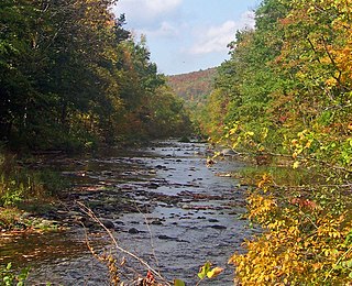
Brown's Station was a hamlet in the Esopus Valley of southeastern Ulster County, New York, United States. It was submerged by the waters of the Ashokan Reservoir, an artificial lake built between 1906 and 1915 to supply fresh water to New York City.[1]
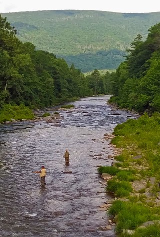
The easternmost hamlet in the town of Olive, Brown's Station was named for Alfred Brown, a prominent local farmer. In the village and its environs, there were farms, boarding houses, shops, and a telegraph office. Two streams flowed through the village: the Esopus Creek and the Beaverkill Creek, which merged, at the downhill end of the village, retaining the name, Esopus Creek. Brown's Station was a popular spot, especially for vacationers from New York City, who would come to swim in the creeks, and to enjoy rafting (using rubber inner tubes), boating, and fishing.
The village was served by the Ulster and Delaware Railroad; the railroad depot called Brown's Station, which lent the hamlet its name, was one of the busiest passenger and freight depots in the Esopus Valley. The depot at Brown's Station was an instrument of its own demise; shipments of cement were transported there for use in the construction of the Ashokan Reservoir.
Having already impounded part of the nearby Croton River and most of its tributaries, agents of the City of New York surveyed a number of places to build another reservoir. Eventually, they decided to flood the Esopus Valley. They started building the dam in 1906, using Rosendale cement, a high-quality hydraulic cement produced at Rosendale in the central part of Ulster County. When the dam was completed in 1912, the sluice was closed and water flooded the valley, a process which was completed in 1915. The buildings of Brown's Station had either been moved or abandoned.[2]
Although Brown Station was flooded, some homes retained the town as their address. In the 1950s, letters to Paula Cohen, a nearby resident, were still addressed to Brown Station.
Olive is a town in Ulster County, New York, United States. The town is west of Kingston, New York, and is inside the Catskill Park. The population was 4,226 at the 2020 census.
Rosendale is a town in the center of Ulster County, New York, United States. It once contained a village Rosendale, primarily centered around Main Street, but which was dissolved through vote in 1977. The population was 5,782 at the 2020 census.
Rosendale is a hamlet located in the Town of Rosendale in Ulster County, New York, United States. The population was 1,285 at the 2020 census. It was also a census-designated place known as Rosendale Village until 2010, when the U.S. Census Bureau designated it Rosendale Hamlet. Some maps continue to list the place as just Rosendale. As of 2020, the "Hamlet" in the CDP name was dropped.
The Catskill Mountains, also known as the Catskills, are a physiographic province and subrange of the larger Appalachian Mountains, located in southeastern New York. As a cultural and geographic region, the Catskills are generally defined as those areas close to or within the borders of the Catskill Park, a 700,000-acre (2,800 km2) forest preserve protected from many forms of development under New York state law.
Rondout Creek is a 63.3-mile-long (101.9 km) tributary of the Hudson River in Ulster and Sullivan counties, New York, United States. It rises on Rocky Mountain in the eastern Catskills, flows south into Rondout Reservoir, part of New York City's water supply network, then into the valley between the Catskills and the Shawangunk Ridge, where it goes over High Falls and finally out to the Hudson at Kingston, receiving along the way the Wallkill River.
The Ashokan Reservoir is a reservoir in Ulster County, New York. It is at the eastern end of the Catskill Park, and is one of several in the region created to provide the City of New York with water. It is the city's deepest reservoir at 190 feet (58 m) near the dam at the former site of Bishop Falls.
Ashokan was a former railroad station located in the Shokan section of the town of Olive, Ulster County, New York, United States. Located 16.2 miles (26.1 km) from the terminus at Kingston Point in Kingston, it was located along the Ulster and Delaware Railroad, later the Catskill Mountain Branch of the New York Central Railroad. The station opened on June 8, 1913, when the railroad abandoned their former alignment due to the construction of the Ashokan Reservoir. The railroad moved the station depot at Brown's Station to Ashokan for service.
Esopus Creek is a 65.4-mile-long (105.3 km) tributary of the Hudson River that drains the east-central Catskill Mountains in the U.S. state of New York. From its source at Winnisook Lake on the slopes of Slide Mountain, the Catskills' highest peak, it flows across Ulster County to the Hudson at Saugerties. Many tributaries extend its watershed into neighboring Greene County and a small portion of Delaware County. Midway along its length, it is impounded at Olive Bridge to create Ashokan Reservoir, the first of several built in the Catskills as part of New York City's water supply system. Its own flow is supplemented 13 miles (21 km) above the reservoir by the Shandaken Tunnel, which carries water from the city's Schoharie Reservoir into the creek.
New York State Route 28A (NY 28A) is an east–west state highway in Ulster County, New York, in the United States. It extends for nearly 20 miles (32 km) along the south side of Ashokan Reservoir in Catskill Park, serving as a southerly alternate route of NY 28 through the area. Many of the communities along its length, such as West Shokan and Olivebridge, are relocated versions of those condemned for the reservoir's construction. Near Olivebridge, NY 28A intersects NY 213, the only other state route that NY 28A intersects aside from its parent, NY 28.
Cold Brook is a former railroad station in the Boiceville section of the town of Olive, Ulster County, New York, United States. Located on Cold Brook Road, just north of New York State Route 28A next to Esopus Creek, Cold Brook station served the New York Central Railroad's Catskill Mountain Branch, formerly the Ulster and Delaware Railroad. The station was located 22.1 miles (35.6 km) northwest of Kingston Point station in the city of Kingston.
The railway station of the hamlet of Brodhead's Bridge in Olive, New York was at milepost 18.1 on the Ulster and Delaware Railroad. It was a destination for tourists and vacationers from New York City who would stay at local resort homes and use the nearby Esopus Creek to swim and fish. Similar resort villages named Atwood and Olive Bridge were also served by this station, which was abandoned in 1913 before it was submerged by the waters of the newly built Ashokan Reservoir.
Brown's Station, MP 15.8, was one of the pre-fabricated stations that was built for the Ulster and Delaware Railroad in the early 1900s, this one being constructed in 1900: the same year the railroad reached Oneonta. This was one of the stations that was located in the Ashokan Valley, and served the small town of Brown's Station, New York, which is now underwater.
New York State Route 213 (NY 213) is a state highway located entirely in Ulster County. It runs from the eastern Catskills to downtown Kingston.
The Schoharie Reservoir is a reservoir in the Catskill Mountains of New York State that was created to be one of 19 reservoirs that supplies New York City with water. It was created by impounding Schoharie Creek. Portions of it lie in the towns of Conesville and Gilboa in Schoharie County, Roxbury in Delaware County, and Prattsville in Greene County.
The Catskill Aqueduct, part of the New York City water supply system, brings water from the Catskill Mountains to Yonkers where it connects to other parts of the system.
The Wallkill Valley Rail Trail is a 23.7-mile (38.1 km) rail trail and linear park that runs along the former Wallkill Valley Railroad rail corridor in Ulster County, New York, United States. It stretches from Gardiner through New Paltz, Rosendale and Ulster to the Kingston city line, just south of a demolished, concrete Conrail railroad bridge that was located on a team-track siding several blocks south of the also-demolished Kingston New York Central Railroad passenger station. The trail is separated from the Walden–Wallkill Rail Trail by two state prisons in Shawangunk, though there have been plans to bypass these facilities and to connect the Wallkill Valley Rail Trail with other regional rail-trails. The northern section of the trail forms part of the Empire State Trail.
Wittenberg Mountain, locally "the Wittenberg'', is a mountain in Ulster County, New York. It is part of the Burroughs Range of the Catskill Mountains. Wittenberg is flanked to the southwest by Cornell Mountain and to the northeast by Terrace Mountain.
Hurley is a town in Ulster County, New York, United States. The population was 6,178 at the 2020 census. The town is in the northeastern part of the county, west of the city of Kingston. Much of the town is inside the Catskill Park. Located within the town is a hamlet and census-designated place, also named Hurley. The Town of Hurley comprises the hamlets of Hurley, West Hurley and Glenford.
Kingston is the only city in, and the county seat of, Ulster County, New York, United States. It is 91 miles (146 km) north of New York City and 59 miles (95 km) south of Albany. The city's metropolitan area is grouped with the New York metropolitan area around Manhattan by the United States Census Bureau. The population was 24,069 at the 2020 United States Census.
Michael P. Hein is an American politician who served as the 1st County Executive of Ulster County, serving until February 10, 2019 after having first been elected on November 4, 2008. Prior to the creation of this position, the 2008 ratification by referendum of the Ulster County Charter, he was the Ulster County Administrator.
This page is based on this Wikipedia article Text is available under the CC BY-SA 4.0 license; additional terms may apply. Images, videos and audio are available under their respective licenses.