
Walton County is a county located on the Emerald Coast in the northwestern part of the U.S. state of Florida, with its southern border on the Gulf of Mexico. As of the 2020 census, the population was 75,305. Its county seat is DeFuniak Springs. The county is home to the highest natural point in Florida: Britton Hill, at 345 feet (105 m). Walton County is included in the Crestview–Fort Walton Beach–Destin Metropolitan Statistical Area.
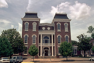
Bullock County is a county of the U.S. state of Alabama. As of the 2020 census, the population was 10,357. Union Springs was chosen as the county seat in 1867, and presently is the county's only incorporated city. The county was named for Confederate Army Colonel Edward C. Bullock who was a state senator and outspoken secessionist who died during the American Civil War.
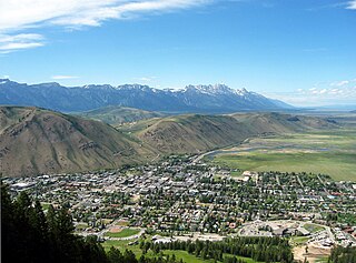
Jackson is a resort town in Teton County, Wyoming, United States. The population was 10,760 at the 2020 census, up from 9,577 in 2010. It is the largest town in Teton County and its county seat. Jackson is the principal town of the Jackson, WY-ID Micropolitan Statistical Area, which includes Teton County in Wyoming and Teton County in Idaho. The town, often familiarly or mistakenly called Jackson Hole, derives its name from the valley in which it is located. Jackson is a popular tourist destination due to its proximity to the ski resorts Jackson Hole Mountain, Snow King Mountain, and Grand Targhee, as well as Grand Teton National Park and Yellowstone National Park.

Walton is a town in Delaware County, New York, United States. The population was 5,270 at the 2020 census. The town is in the west-central part of the county and contains the village of Walton. The town claims to be the "Scarecrow Capital of the World."

Britton Hill is the highest natural point in the state of Florida, United States, with a summit elevation of 345 feet above mean sea level. Britton Hill is the lowest state highpoint in the United States, 103 feet (31 m) lower than the next lowest highpoint, Ebright Azimuth in Delaware, and far lower than many skyscrapers in Miami, Jacksonville, Tampa and Orlando, of which the highest, Panorama Tower in Miami, reaches 861 feet above mean sea level.
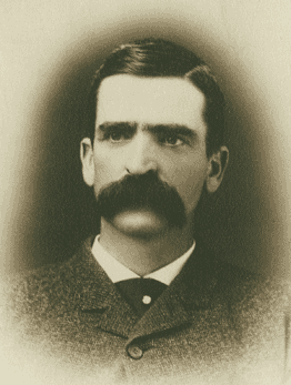
Seth Bullock was a Canadian-American frontiersman, business proprietor, politician, sheriff, and U.S. Marshal. He was a prominent citizen in Deadwood, South Dakota, where he lived from 1876 until his death, operating a hardware store and later a large hotel, the Bullock Hotel.
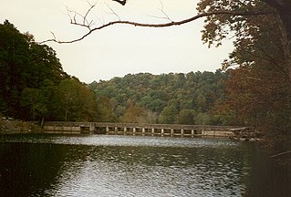
Standing Stone State Park is a state park in Overton County, Tennessee, in the southeastern United States. The park consists of 855 acres (3.46 km2) along the shoreline of the man-made 69-acre (0.28 km2) Standing Stone Lake. The 11,000-acre (45 km2) Standing Stone State Forest surrounds the park.

Ivanpah was a short-lived silver mining town located in San Bernardino County, California, United States. It was founded in 1869 and existed until at least the mid-1880s.
Sioux National Forest was a National Forest (NF) established by Executive Order 908 on July 1, 1908. The order called for the consolidation of the following national forests and forest units into a single entity:
Walton is an unincorporated community in Roane County, West Virginia, United States. Walton is located on U.S. Route 119, 11.5 miles (18.5 km) south-southwest of Spencer. Walton has a post office with ZIP code 25286.
Starkweather Hill is a mountain located in the Catskill Mountains of New York east-southeast of Walton, New York, and likewise a hill located in the Hidden Hills of Massachusetts west-southwest of Worthington Corners and west-northwest of Worthington Center, Massachusetts, which was named for a noted settler upon it, the Hon. Dr. Ezra Starkweather, colonial physician, revolutionary war soldier, and later a state legislator, but which refers today to one prominence on a ridgeline massif known as West Hill that is situated at north latitude 42 degrees, 24 minutes, 22 seconds and west longitude 72 degrees, 57 minutes, 42 seconds, within the Fox Den State Wildlife Management Area, and is approached from the southeast by Starkweather Hill Road.
Walton Mountain is a mountain located in the Catskill Mountains of New York state, west of Walton. Bullock Hill is located northwest of Walton Mountain, while Clabber Peak is located southwest of it, and Crane Hill is located southeast of it.
Crane Hill is a mountain located in the Catskill Mountains of New York southwest of Walton. Walton Mountain is located northwest, South Mountain is located east, and Bear Spring Mountain is located east of Crane Hill.
Loomis Mountain is a mountain located in the Catskill Mountains of New York northwest of Walton. Walton Mountain is located south, Pines Brook Ridge is located southeast, and Gallop Hill is located north-northwest of Loomis Mountain.
Carroll Hill is a mountain located in the Catskill Mountains of New York southwest of Trout Creek. Bullock Hill is located northeast and Clabber Peak is located south-southeast of Carroll Hill.
Van Loan Hill is a mountain in Greene County, New York. It is located in the Catskill Mountains southwest of Maplecrest. Round Hill is located west, Elm Ridge is located north-northeast, and East Jewett Range is located south of Van Loan Hill.

Tower Mountain is a mountain located in the Catskill Mountains of New York state, east-northeast of Deposit in Delaware County. Speedwell Mountain is located west-southwest of Tower Mountain, Walton Mountain is located north-northeast of it, and Crane Hill is located northeast of Tower Mountain. In 1934, the Civilian Conservation Corps built what was known as the Rock Rift Fire Observation Tower on the mountain. The tower ceased fire lookout operations at the end of the 1988 season and was officially closed in early 1989. Currently, the tower is not safe to climb. The first set of steps has been removed to prevent injury. Restoration of the tower is planned by the Town of Tompkins.

Mount Izaak Walton is a 12,077-foot-elevation (3,681 meter) mountain summit located in the Sierra Nevada mountain range in Fresno County of northern California, United States. It is situated in the John Muir Wilderness, on land managed by Sierra National Forest. Mount Izaak Walton ranks as the 404th-highest summit in California. Topographic relief is significant as the northwest aspect rises 1,800 feet above Izaak Walton Lake in approximately one mile. It is six miles northeast of Lake Thomas A Edison, and approximately 14 miles (23 km) south-southeast of the community of Mammoth Lakes. The peak is set on Silver Divide, so precipitation runoff from the north side of this mountain drains into Fish Creek which is a tributary of the San Joaquin River, and from the south slope to Mono Creek, also a tributary of the San Joaquin.

