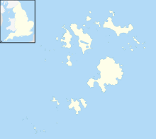
Tresco is the second-biggest island of the Isles of Scilly. It is 297 ha (1.15 sq mi) in area, measuring about 3.5 km (2.2 mi) by 1.75 km (1.09 mi).

Bryher is one of the smallest inhabited islands of the Isles of Scilly, with a population of 84 in 2011, spread across 134 hectares (1.34 km2). Bryher exhibits a procession of prominent hills connected by low-lying necks and sandy bars. Landmarks include Hell Bay, famous for shipwrecks in the 18th and 19th centuries, Shipman Head, which was fortified in the Iron Age and where the tumbled ramparts of an Iron Age castle remain, and All Saints' Church, originally constructed in 1742. The island has two quays, Church Quay and Bar Quay.

Annet is the second-largest of the fifty or so uninhabited Isles of Scilly, one kilometre west of St Agnes with a length of one kilometre and approximately 22 hectares in area. The low-lying island is almost divided in two by a narrow neck of land at West Porth which can, at times, be covered by waves. At the northern end of the island are the two granite carns of Annet Head and Carn Irish and three smaller carns known as the Haycocks. The rocky outcrops on the southern side of the island, such as South Carn, are smaller. Annet is a bird sanctuary and the main seabird breeding site in Scilly.

Gugh could be described as the sixth inhabited island of the Isles of Scilly, but is usually included with St Agnes with which it is joined by a sandy tombolo known as "The Bar" when exposed at low tide. The island is only about 1 km (0.62 mi) long and about 0.5 km (0.31 mi) wide, with the highest point, Kittern Hill at 34 m (112 ft). The geology consists of Hercynian granite with shallow podzolic soils on the higher ground and deeper sandy soils on the lower ground. The former Gugh farm is just north of the neck across the middle of the island between the two hills. The two houses were designed and built in the 1920s by Charles Hamlet Cooper.

Cromwell's Castle is an artillery fort overlooking New Grimsby harbour on the island of Tresco in the Isles of Scilly. It comprises a tall, circular gun tower and an adjacent gun platform, and was designed to prevent enemy naval vessels from entering the harbour. The castle was built in two phases; Sir Robert Blake constructed the tower between 1651 and 1652 in the aftermath of the Parliamentary invasion of the islands at the end of the English Civil War, and Master Gunner Abraham Tovey added the gun platform during the War of Jenkins' Ear around 1739. The tower fell into disuse soon afterwards, and in the 21st century is managed by English Heritage and open to visitors.
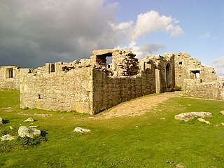
King Charles's Castle is a ruined artillery fort overlooking New Grimsby harbour on the island of Tresco in the Isles of Scilly. Built between 1548 and 1551 to protect the islands from French attack, it would have held a battery of guns and an accompanying garrison, designed to prevent enemy vessels from entering the harbour. The castle is polygonal in design, constructed from granite stone, with the gun battery at the front, and a dining room, kitchen and living accommodation at the rear. An additional defensive earthwork was constructed around it during the 17th century. The design of the castle is unusual for the period, and is only seen elsewhere in blockhouses along the River Thames.

St Helen's is one of the fifty or so uninhabited islands in the archipelago of the Isles of Scilly and has an approximate area of 0.1885 square kilometres. On the south side of the island is one of the earliest Christian sites in Scilly, an early medieval religious complex, which is thought to be the remains of St Elidius Hermitage, an 8th-century chapel lived in by Saint Lide,. There are also the remains of an isolation hospital used to quarantine sailors with plague. The island is the major part of a Site of Special Scientific Interest and some features have been given the designation of scheduled ancient monument. Access to the island is through chartered or private boat, although there are some season trips throughout the summer. St Helen's is currently managed by the Isles of Scilly Wildlife Trust.

The Isles of Scilly are a small archipelago off the southwestern tip of Cornwall, England, United Kingdom. One of the islands, St Agnes, is over four miles further south than the most southerly point of the British mainland at Lizard Point.

White Island is one of the larger unpopulated islands of the Isles of Scilly, part of the United Kingdom, and lies off the coast of the northernmost populated island of the group, St Martin's, to which it is joined by a tidal causeway, or isthmus. The island is designated as a Site of Special Scientific Interest (SSSI) and a Geological Conservation Review site and is managed by the Isles of Scilly Wildlife Trust on behalf of the Duchy of Cornwall.
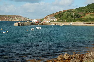
New Grimsby is a coastal settlement on the island of Tresco in the Isles of Scilly, England. It is located on the west side of the island and there is a quay, as well as a public house, The New Inn, and a small art gallery.

Wingletang Down is a Site of Special Scientific Interest (SSSI) on the southern side of the island of St Agnes in the Isles of Scilly, England, UK, which is noted for its biological characteristics. All of the land designated as Wingletang Down SSSI is owned by the Duchy of Cornwall. The site is managed by the Isles of Scilly Wildlife Trust and is within the Isles of Scilly Heritage Coast and the Isles of Scilly Area of Outstanding Natural Beauty. It is the only site in Great Britain and Ireland for the small fern, least adder's–tongue. As of 11 September 2009 the SSSI was considered to be in ″unconditional recovering″ condition because European gorse and bramble are at unacceptable levels.

The Eastern Isles are a group of twelve small uninhabited islands within the Isles of Scilly Area of Outstanding Natural Beauty, part of the Scilly Heritage Coast and a Site of Special Scientific Interest (SSSI) first designated in 1971 for its flora and fauna. They have a long period of occupation from the Bronze Age with cairns and entrance graves through to Iron Age field systems and a Roman shrine on Nornour. Before the 19th century, the islands were known by their Cornish name, which had also become the name of the largest island in the group after the submergence of the connecting lands.
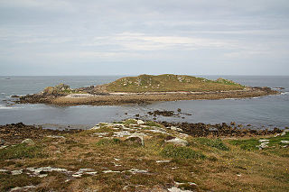
The Norrard (Northern) Rocks are a group of small uninhabited granite rocks in the north–western part of the Isles of Scilly, to the west of Bryher and Samson. In 1971 they were designated as a Site of Special Scientific Interest (SSSI) for their breeding seabird colonies and they are permanently closed to landings from boat passengers. The vegetation on the islands is limited by the extreme exposure and only six species of flowering plants have been recorded.

Peninnis Head is the southernmost point of St Mary's, Isles of Scilly. The headland is within the Isles of Scilly Area of Outstanding Natural Beauty and part of the Heritage Coast. It is also a Geological Conservation Review site for its Quaternary geomorphology and was first designated a Site of Special Scientific Interest (SSSI) in 1971 for both its biological and geological interests. All of the land designated as Peninnis Head SSSI is owned by the Duchy of Cornwall. On the tip of the headland is a squat lighthouse built in 1911 by Trinity House as a replacement for the 17th century lighthouse on St Agnes.
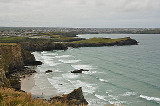
Cornish promontory forts, commonly known in Cornwall as cliff castles, are coastal equivalents of the hill forts and Cornish "rounds" found on Cornish hilltops and slopes. Similar coastal forts are found on the north–west European seaboard, in Normandy, Brittany and around the coastlines of the British Isles, especially in Wales, Scotland and Ireland. Many are known in southwest England, particularly in Cornwall and its neighbouring county, Devon. Two have been identified immediately west of Cornwall, in the Isles of Scilly.

The Old Blockhouse, also known as the Dover Fort, is a 16th-century fortification on the island of Tresco in the Isles of Scilly. It was built between 1548 and 1551 by the government of Edward VI to protect the islands against French attack.

Oliver's Battery is a ruined artillery battery on the island of Tresco in the Isles of Scilly off of Cornwall, England. It was built by the Parliamentarian admiral, Sir Robert Blake, after he invaded Tresco in April 1651 during the years of the interregnum. It was used to bombard the neighbouring island of St Mary's, which was still held by an opposing Royalist army, and forced its surrender several weeks later. The battery comprised a triangle of ramparts, constructed using earth and rubble, which, combined with the natural stone features on the site, produced a substantial, if crude, fortification. It is now ruined, and owned by the Duchy of Cornwall.
Tresco is a civil parish in the Isles of Scilly, Cornwall, England. The parish contains 16 buildings that are recorded in the National Heritage List for England as designated listed buildings. Of these, two are listed at Grade II*, the middle grade, and the others are at Grade II, the lowest grade. The largest island in the parish is Tresco, and the parish also includes Round Island with its listed lighthouse. The oldest listed building consists of the ruins of a Benedictine priory dating from about 1300.T he island had a strategic importance and this is reflected in its three listed fortifications. In the 19th century, a country house, Tresco Abbey, was built close to the ruins of the priory, and its grounds have been transformed into Tresco Abbey Gardens. Listed buildings in addition to those mentioned above include houses, farm outbuildings, a church, a monument, and the wall of a former kelp pit.

Harry's Walls are the remains of an unfinished artillery fort, started in 1551 by the government of Edward VI to defend the island of St Mary's in the Isles of Scilly. Constructed to defend the harbour of Hugh Town from possible French attack, the fortification incorporated Italianate-style bastions with protective orillons and would have been the most advanced design in the kingdom at the time. It was not completed, probably due to a shortage of funds and the passing of the invasion threat, and only the south-west side remains. In the 21st century, Harry's Walls are managed by English Heritage and open to visitors.
