
Portland is a port city in the Pacific Northwest and the most populous city in the U.S. state of Oregon. Situated in the northwestern area of the state at the confluence of the Willamette and Columbia rivers, Portland is the county seat of Multnomah County, the most populous county in Oregon. As of 2020, Portland had a population of 652,503, making it the 26th-most populous city in the United States, the sixth-most populous on the West Coast, and the second-most populous in the Pacific Northwest, after Seattle. Approximately 2.5 million people live in the Portland–Vancouver–Hillsboro, OR–WA metropolitan statistical area, making it the 25th most populous in the United States. About half of Oregon's population resides within the Portland metropolitan area.

The Willamette River is a major tributary of the Columbia River, accounting for 12 to 15 percent of the Columbia's flow. The Willamette's main stem is 187 miles (301 km) long, lying entirely in northwestern Oregon in the United States. Flowing northward between the Oregon Coast Range and the Cascade Range, the river and its tributaries form the Willamette Valley, a basin that contains two-thirds of Oregon's population, including the state capital, Salem, and the state's largest city, Portland, which surrounds the Willamette's mouth at the Columbia.

Wilsonville is a city primarily in Clackamas County, Oregon, United States. A portion of the northern section of the city is in Washington County. It was founded as Boones Landing because of the Boones Ferry which crossed the Willamette River at the location; the community became Wilsonville in 1880. The city was incorporated in 1969 with a population of approximately 1,000. The population was 13,991 at the 2000 census, and grew to 19,509 as of 2010. Slightly more than 90% of residents at the 2000 census were white, with Hispanics comprising the largest minority group.

The Portland Streetcar is a streetcar system in Portland, Oregon, that opened in 2001 and serves areas surrounding downtown Portland. The 3.9-mile (6.3 km) NS Line runs from Northwest Portland to the South Waterfront via Downtown and the Pearl District. The Loop Service, which opened in September 2012 as the Central Loop, runs from Downtown to the Oregon Museum of Science and Industry via the Pearl District, the Broadway Bridge across Willamette River, the Lloyd District, and the Central Eastside Industrial District and added 3.3 miles (5.3 km) of route. In September 2015 the line was renamed as the Loop Service, with the A Loop traveling clockwise, and the B Loop traveling counterclockwise. The two-route system serves some 20,000 daily riders.
The Oregon and California Railroad was formed from the Oregon Central Railroad when it was the first to operate a 20-mile (32 km) stretch south of Portland in 1869. This qualified the railroad for land grants in California, whereupon the name of the railroad soon changed to Oregon & California Rail Road Company. In 1887, the line was completed over Siskiyou Summit, and the Southern Pacific Railroad assumed control of the railroad, although it was not officially sold to Southern Pacific until January 3, 1927. This route was eventually spun off from the Southern Pacific as the Central Oregon and Pacific Railroad.

The Broadway Bridge is a Rall-type bascule bridge spanning the Willamette River in Portland, Oregon, United States, built in 1913. It was Portland's first bascule bridge, and it continues to hold the distinction of being the longest span of its bascule design type in the world. It was added to the National Register of Historic Places in November 2012.

The BNSF Railway Bridge 5.1, also known as the St. Johns Railroad Bridge or the Willamette River Railroad Bridge, is a through truss railway bridge with a vertical lift that spans the Willamette River in Portland, Oregon, United States. Built by the Spokane, Portland and Seattle Railway (SP&S) and completed in 1908, it was originally a swing-span bridge, and its swing-span section was the longest in the world at the time. However, 81 years later the main span was converted from a swing-type to a vertical-lift type, in order to widen the navigation channel. The lift span is one of the highest and longest in the world. The bridge consists of five sections, with the two sections closest to the bank on each side fixed.
Like transportation in the rest of the United States, the primary mode of local transportation in Portland, Oregon is the automobile. Metro, the metropolitan area's regional government, has a regional master plan in which transit-oriented development plays a major role. This approach, part of the new urbanism, promotes mixed-use and high-density development around light rail stops and transit centers, and the investment of the metropolitan area's share of federal tax dollars into multiple modes of transportation. In the United States, this focus is atypical in an era when automobile use led many areas to neglect their core cities in favor of development along interstate highways, in suburbs, and satellite cities.
Portland is "an international pioneer in transit orientated developments."

Downtown Portland is the central business district of Portland, Oregon, United States. It is on the west bank of the Willamette River in the northeastern corner of the southwest section of the city and where most of the city's high-rise buildings are found.

The history of the city of Portland, Oregon, began in 1843 when business partners William Overton and Asa Lovejoy filed to claim land on the west bank of the Willamette River in Oregon Country. In 1845 the name of Portland was chosen for this community by coin toss. February 8, 1851, the city was incorporated. Portland has continued to grow in size and population, with the 2010 Census showing 583,776 residents in the city.

East Portland was a city in the U.S. state of Oregon that was consolidated into Portland in 1891. In modern usage, the term generally refers to the portion of present-day Portland that lies east of 82nd Avenue, most of which the City of Portland annexed in the 1980s and 1990s.
Historic ferries in Oregon are water transport ferries that operated in Oregon Country, Oregon Territory, and the state of Oregon, United States. These ferries allowed people to cross bodies of water, mainly rivers such as the Willamette in the Willamette Valley, and the Columbia, in order to transport goods, move people, and further communications until permanent bridges were built to allow faster crossing of the water. The early ferries were used by wagons and pedestrians, while later ones transported trains and then automobiles. Oregon has a few automobile ferries still in operation.

Boone Bridge is a steel girder highway bridge over the Willamette River at Wilsonville, Oregon, in the United States. Built in 1954, it crosses the river to the Charbonneau section of Wilsonville, carrying Interstate 5 into the open Willamette Valley from the Portland metropolitan area. Maintained by the Oregon Department of Transportation, the 1,111-foot-long (339 m) bridge has three travel lanes in each direction. To the west is the site of the former Boone's Ferry, which the bridge replaced.

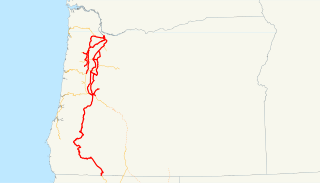
Interstate 5 (I-5) in the U.S. state of Oregon is a major Interstate Highway that traverses the state from north to south. It travels to the west of the Cascade Mountains, connecting Portland to Salem, Eugene, Medford, and other major cities in the Willamette Valley and across the northern Siskiyou Mountains. The highway runs 308 miles (496 km) from the California state line near Ashland to the Washington state line in northern Portland, forming the central part of Interstate 5's route between Mexico and Canada.
Rail transportation is an important element of the transportation network in the U.S. state of Oregon. Rail transportation has existed in Oregon in some form since 1855, and the state was a pioneer in development of electric railway systems. While the automobile has displaced many uses of rail in the state, rail remains a key means of moving passengers and freight, both within the state and to points beyond its borders.

James B. Stephens was a pioneer of the U.S. state of Oregon. A cooper by trade, he operated one of the first ferries across the Willamette River at what was East Portland, Oregon. His father was the first burial at Portland's Lone Fir Cemetery. A native of Virginia, he was the founder of East Portland and Stephens Street in Portland, Oregon is named in his honor.

The Oregon Central Rail Road was the name of two railroad companies in the U.S. state of Oregon, each of which claimed federal land grants that had been assigned to the state in 1866 to assist in building a line from Portland south into California. The "East Side Company" of Salem, supported by businessman Ben Holladay, eventually received the grant for its line east of the Willamette River, and was reorganized in 1870 as the Oregon and California Railroad (O&C), which completed the line in 1887. Portland supported the competing "West Side Company", which only built to McMinnville, and was sold to the O&C in 1880. The O&C was later acquired by the Southern Pacific Company, and mostly remains as part of the Union Pacific Railroad's I-5 Corridor; the West Side line is now operated by the Portland and Western Railroad between Beaverton and Forest Grove.
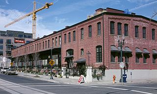
The North Bank Depot Buildings, in central Portland, Oregon, United States, are a pair of buildings formerly used as a freight warehouse and passenger terminal for the Spokane, Portland and Seattle Railway (SP&S). Formed in 1905, the SP&S was commonly known as the North Bank Road during the period in which these buildings were in use. The Portland buildings' passenger facilities were also used by the Oregon Electric Railway after that railway was acquired by the SP&S. Located in what is now known as the Pearl District, the buildings were listed on the National Register of Historic Places in 1996. They were in use by the SP&S and its successor, Burlington Northern Railroad, from 1908 until the 1980s. Only the east building was used as a passenger station, and this usage lasted from 1908 until 1931.

The Portland General Electric Company Station "L" Group in southeast Portland in the U.S. state of Oregon was a cluster of six industrial buildings listed on the National Register of Historic Places. Built between 1910 and 1929 by Portland General Electric (PGE), it was added to the register in 1985. In 1986, PGE gave Station L and 18.5 acres (7.5 ha) of land to the Oregon Museum of Science and Industry (OMSI). The Station L turbine is a central feature of OMSI's Turbine Hall. The complex was listed on the National Register in 1985, and was delisted in 2020.

The A and B Loop is a streetcar circle route of the Portland Streetcar system in Portland, Oregon, United States. Operated by Portland Streetcar, Inc. and TriMet, it is made up of two separate services: the 6.1-mile (9.8 km) A Loop, which runs clockwise, and the 6.6-mile (10.6 km) B Loop, which runs counterclockwise. The route travels a loop between the east and west sides of the Willamette River by crossing the Broadway Bridge in the north and Tilikum Crossing in the south.
