The town was gazetted on 11 January 1865.[9] It was situated near Gowrie's Crossing, a permanent waterhole, now on the outskirts of the modern town. It was planned with very wide streets to enable bullock teams of up to 14 pairs to turn with their wagons.[10] It was William Alcock Tully, who was Commissioner of Crown Lands in the Warrego District from 1863 to 1864 and would later serve as Surveyor General of Queensland from 1875 to 1889, who laid out the town's streets. An Irishman, Tully probably named the town after the town of Charleville, County Cork, Ireland.[2][11]
A hotel was built in 1865. Charleville Post Office opened on 1 August 1865[12] and a town began to grow to service the region. Members of the Roma-based Skinner family established a store in the town in 1872 that became known as the Warrego Stores[13] and Edward and Margot Kelly ran the Charleville Hotel together from 1928.[14]
In September 1875, the Queensland Government called for tenders to erect a courthouse in Charleville.[15] The foundation stone (actually a bloodwood block) was laid on 23 November 1875.[16] By January 1876, the courthouse was almost finished.[17]
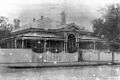
Architectural drawing of the Charleville Hospital, 1884First Charleville Hospital, circa 1911Charleville Hospital, 2024
In December 1884, the Queensland Government called for tenders to erect a hospital in Charleville.[18] In March 1885 the contract was awarded to Richards and King for £2,265 10s.[19] In November 1885, a hospital ball was held in the new hospital building, suggesting it was completed and opened around that time.[20]
Cobb and Co, the legendary Australian stagecoach company, established a coach building business in the town in 1886. however, the railway arrived in 1888, beginning the long demise of coach transport in the area. Charleville railway station opened on 1 March 1888 and was the terminus for the Western railway line until the line was extended south to Cunnamulla in 1898. Facilities included a locomotive depot, cattle and sheep yards, a 50-ton weighbridge, a booking and telegraph offices, goods shed, stationmaster's house, and guards, enginemen and firemen's cottages.[21] Apart from the railway station in Charleville, there were also two now-abandoned railway sidings:
In July 1886 the Anglican residents of the town decided to erect a church.[23] All Saint's Anglican Church was opened on by Rev. B. R. Wilson on 20 November 1887. It was designed by diocesan architect John Hingestone Buckeridge and built by Mr. Wood.[24] It was dedicated in 1897. The foundation stone for the present church was laid in September 1957 by ArchbishopReginald Halse.[25] The new church was dedicated in 1958 and consecrated in 1967.[26]
In 1902 Charleville was the location of an unsuccessful attempt by Clement Lindley Wragge to fire cannons into the clouds in order to break a drought. The cannons used remain on display in Charleville today.[27]
St Mary's Catholic Primary School was opened on 26 January 1913 by the Sisters of Mercy with 108 students.[28][29] By the 1950s, there were over 400 students with a dozen sisters teaching at the school. During the 1960s and 1970s, the school also offered secondary education.[30] The school suffered extensive damage during the April 1990 flood which devastated Charleville.[31]
Aerial view of Charleville in 1947
In 1922, Qantas established an airmail service between Charleville and Cloncurry. At the same time, this was Qantas's first regularly scheduled route.[32]
"Scott and Black, keeping up their sensational pace, flashed into Charleville, refueled, sped toward the finish where waiting thousands cheered their progress, reported over loudspeakers. With one motor dead, with only two hours sleep since leaving England, the Britons triumphantly set their scarlet torpedo down in Melbourne at 3:34 p.m. In 71 hr. 1 min. 3 sec. – Just under three days – they had flown halfway around the world."[35]
Proximity to the Warrego River has been problematic. Charleville was hit by flooding in 1971 caused by a rain depression that was formed from the remnants of Cyclone Althea.[citation needed]
In April 1990, major floods hit western Queensland, with Charleville being badly affected. Floodwaters peaked at 8.54 metres, over 1,000 homes were inundated, and almost 3,000 people evacuated. Charleville State School and St Mary's School both suffered extensive damage during the April 1990 floods which devastated Charleville.[citation needed]
The district suffered flooding again in 1997, 2008 and March 2010.[36][37] Flooding also occurred in February 2012.[38]
A levee was built by the Murweh Shire Council, which was completed in 2009, which protected the town during the 2012 floods (although the floodwater rose close to the top of the levee), but there was still significant flooding in the wider area. In 2013, a diversion and levee system was built to also protect the town from flooding in Bradley’s Gully.[39]
Demographics
In the 2016 census, the locality of Charleville had a population of 3,335 people. Aboriginal and Torres Strait Islander people made up 15.3% of the population. 83.6% of people were born in Australia; the next most common country of birth was Vietnam at 3.3%. 87.6% of people spoke only English at home; other languages spoken at home included Vietnamese at 3.5%. The most common responses for religion were Catholic 34.1%, Anglican 24.1% and No Religion 17.2%.[40]
In the 2021 census, the locality of Charleville had a population of 2,992 people.[1]
Geography
Located in southwestern Queensland, Australia, Charleville is the terminus for the Warrego Highway, which stretches 747 kilometres (464 miles) from Brisbane and is situated:
It is the largest town and administrative centre of the Shire of Murweh, which covers an area of 43,905 square kilometres. Charleville is situated on the banks of the Warrego River.
Charleville State High School is a government secondary (7–12) school for boys and girls on the corner of Partridge and Hunter Streets (26°23′51″S146°15′27″E / 26.3974°S 146.2574°E / -26.3974; 146.2574 (Charleville State High School)).[47][51] It was established in 1961, replacing the Secondary Department at Charleville State School. In 2018, the school had an enrolment of 246 students (including students from Augathella, Morven and Wyandra) with 36 teachers (34 full-time equivalent) and 21 non-teaching staff (16 full-time equivalent).[49] It includes a special education program.[47]
Charleville School of Distance Education is a government primary and secondary (Early Childhood to Year 10) school for boys and girls at Parry Street (26°23′42″S146°15′31″E / 26.3950°S 146.2586°E / -26.3950; 146.2586 (Charleville School of Distance Education)).[47][52] In 2018, the school had an enrolment of 200 students with 25 teachers (24 full-time equivalent) and 12 non-teaching staff (10 full-time equivalent).[49] It is a School of the Air, providing distance education by a combination of postal services, telephone and Internet to children who are unable to attend a regular school due to their remote location. It includes a special education program.[47]
Facilities
Charleville has a range of facilities for the community including a swimming pool, bowling green, speedway, racing course, and the Gowrie sporting oval.[53]
The local newspaper is the Western Times. Along with many other regional Australian newspapers owned by NewsCorp, the newspaper ceased print editions in June 2020 and became an online-only publication from 26 June 2020.[62]
Prior to 1994, TheWestlander was divided at Charleville, the service to Quilpie (3Q02) being nicknamed the Flying Flea and consisted of two passenger carriages, a guards van and power van. The remainder of the train (3V02) headed to Cunnamulla via Westgate and Wyandra. In August 1994, passenger services beyond Charleville were discontinued.[citation needed]
Charleville experiences a hot semi-arid climate (Köppen: BSh), with hot summers with variable rainfall and humidity; as well as having mild, dry winters with occasional frost and high high diurnal ranges. Average maxima range from 35.2°C (95.4°F) in January to 19.7°C (67.5°F) in July. Annual precipitation is rather low, averaging 487.3mm (19.19in), and peaks in summer due to more abundant showers and thunderstorms.[73] Severe flooding events can occur due to tropical cyclones remnants and monsoon troughs; evident by the 399.7mm (15.74in) falling in February 1896: the highest monthly total recorded. Extreme temperatures have ranged from 47.0°C (116.6°F) on 27 January 1947 to −5.2°C (22.6°F) on 21 July 1951.[74]
Climate data for Charleville (26º24'36"S, 146º15'36"E, 302 m AMSL) (1942–2024 normals, extremes 1889–2024)
An eponymous country music song about Charleville was written by Don Walker and recorded by Slim Dusty on his album Ringer from the Top End and later by Walker's own band Catfish on the album Ruby.[citation needed]
A children's book called The Flood Grungies was written by Michelle Sheehan and illustrated by Donna Reynolds. It is about the notorious Charleville floods and features the Cosmos centre, the water tower and other famous landmarks.[78]
↑"Town reserve of Charleville – 2,560 acres – Warrego District". Queensland Government Gazette. 11 January 1865. p.6:27.
↑Finn, J. T., One Hundred Years 1847–1947 Charleville (Charleville, 1947), p. 32
↑"Charleville". Centre for the Government of Queensland. Archived from the original on 19 October 2012. Retrieved 20 June 2012.
↑Phoenix Auctions History. "Post Office List". Phoenix Auctions. Archived from the original on 31 May 2022. Retrieved 18 January 2021.
↑Wagner, Clair, Frontier Town – Charleville 1865–1901 (Bollarong Publications, Brisbane, 1991) p. 27
↑Murray, Pamela, "Margaret Elizabeth (Margot) Kelly (1894–1983)", Australian Dictionary of Biography, Canberra: National Centre of Biography, Australian National University, archived from the original on 18 December 2023, retrieved 18 December 2023
↑"Official Notifications". The Brisbane Courier. Vol.XXX, no.2, 594. Queensland, Australia. 13 September 1875. p.3. Archived from the original on 4 December 2020. Retrieved 22 October 2017– via National Library of Australia.
↑"CHARLEVILLE". Western Star And Roma Advertiser. Vol.I, no.37. Queensland, Australia. 4 December 1875. p.3. Archived from the original on 4 December 2020. Retrieved 22 October 2017– via National Library of Australia.
↑"Official Notifications". The Queenslander. Vol.XXVI, no.483. Queensland, Australia. 27 December 1884. p.1045. Archived from the original on 25 September 2020. Retrieved 22 October 2017– via National Library of Australia.
↑"Official Notifications". The Queenslander. Vol.XXVII, no.493. Queensland, Australia. 7 March 1885. p.390. Archived from the original on 25 September 2020. Retrieved 22 October 2017– via National Library of Australia.
↑"CHARLEVILLE". The Brisbane Courier. Vol.XL, no.8, 690. Queensland, Australia. 20 November 1885. p.6. Archived from the original on 25 September 2020. Retrieved 22 October 2017– via National Library of Australia.
This page is based on this Wikipedia article Text is available under the CC BY-SA 4.0 license; additional terms may apply. Images, videos and audio are available under their respective licenses.