Crowley Vale, Queensland

Last updated

Crowley Vale
Queensland
Australia Queensland location map.svg
Red pog.svg
Crowley Vale
Coordinates 27°32′38″S152°22′39″E / 27.5438°S 152.3775°E / -27.5438; 152.3775 (Crowley Vale (centre of locality))
Population106 (2021 census) [1]
 • Density13.25/km2 (34.3/sq mi)
Postcode(s) 4342
Area8.0 km2 (3.1 sq mi)
Time zone AEST (UTC+10:00)
Location
LGA(s) Lockyer Valley Region
State electorate(s) Lockyer
Federal division(s) Wright
Suburbs around Crowley Vale:
Lake Clarendon Glenore Grove Glenore Grove
College View Crowley Vale Glenore Grove
College View Forest Hill Forest Hill

Crowley Vale is a rural locality in the Lockyer Valley Region, Queensland, Australia. [2] In the 2021 census, Crowley Vale had a population of 106 people. [1]

Contents

History

In March 1915, the Queensland Government decided to establish a new open-air school at Verdant Vale. [3] [4] [5] Verdant Vale State School opened in 1916. In 1918, it was renamed Crowley Vale State School. In 1923, the school had 40 children enrolled and parents requested a new school building. [6] The school closed circa 1941. [7] It was at 42 Crowley Vale Road (corner of Warrego Highway, 27°32′37″S152°22′42″E / 27.54374°S 152.37831°E / -27.54374; 152.37831 (Crowley Vale State School (former)) ). [8] [9] In 1951, tenders were called to re-erect the school building at the Gatton Agricultural College as a lunch room for farmhands. [10] In 1996, it was relocated to the western side of Services Road with the college grounds. [11] [12] In 1995, it was re-located to its present position west of Services Road. [13] [14]

Demographics

In the 2016 census, Crowley Vale had a population of 96 people. [15]

In the 2021 census, Crowley Vale had a population of 106 people. [1]

Education

There are no schools in Crowley Vale. The nearest government primary schools are Lake Claredon State School in neighbouring Lake Claredon to the north and Glenore Grove State School in neighbouring Glenore Grove to the east. The nearest government secondary school is Lockyer District State High School in Gatton to the south-west. [16]

Related Research Articles

<span class="mw-page-title-main">Warrego Highway</span> Highway in Queensland

The Warrego Highway is located in southern Queensland, Australia. It connects coastal centres to the south western areas of the state, and is approximately 715 km in length. It takes its name from the Warrego River, which is the endpoint of the highway. The entire highway is part of the National Highway system linking Darwin and Brisbane: formerly National Highway 54, Queensland began to convert to the alphanumeric system much of Australia had adopted in the early-2000s and this road is now designated as National Highway A2.

<span class="mw-page-title-main">Gatton, Queensland</span> Town in Queensland, Australia

Gatton is a rural town and locality in the Lockyer Valley Region, Queensland, Australia. It is the administrative centre of the Lockyer Valley situated in the Lockyer Valley of South East Queensland.

<span class="mw-page-title-main">Laidley, Queensland</span> Town in Queensland, Australia

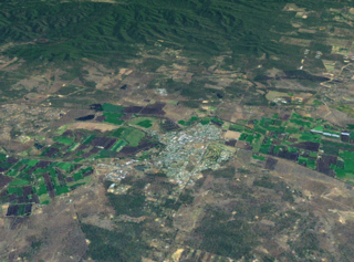
Laidley is a rural town and locality in the Lockyer Valley Region, Queensland, Australia. In the 2021 census, the locality of Laidley had a population of 3,809 people.

<span class="mw-page-title-main">Shire of Laidley</span> Local government area in Queensland, Australia

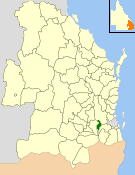
The Shire of Laidley was a local government area located in the Lockyer Valley region between the cities of Toowoomba and Ipswich, and about 70 kilometres (43 mi) west of Brisbane, the state capital of Queensland, Australia. The shire covered an area of 700.6 square kilometres (270.5 sq mi), and existed from 1888 until its merger with the Shire of Gatton to form the Lockyer Valley Region on 15 March 2008.

<span class="mw-page-title-main">Clarendon, Queensland</span> Suburb of Somerset Region, Queensland, Australia

Clarendon is a rural locality in the Somerset Region, Queensland, Australia. In the 2021 census, Clarendon had a population of 232 people.

<span class="mw-page-title-main">Forest Hill, Queensland</span> Town in Queensland, Australia

Forest Hill is a rural town and locality in the Lockyer Valley Region, Queensland, Australia. In the 2021 census, the locality of Forest Hill had a population of 935 people.

<span class="mw-page-title-main">Blenheim, Queensland</span> Suburb of Lockyer Valley Region, Queensland, Australia

Blenheim is a rural locality in the Lockyer Valley Region, Queensland, Australia. In the 2021 census, Blenheim had a population of 264 people.

Flagstone Creek is a rural locality in the Lockyer Valley Region, Queensland, Australia. In the 2021 census, Flagstone Creek had a population of 256 people.

<span class="mw-page-title-main">Fordsdale, Queensland</span> Suburb of Lockyer Valley Region, Queensland, Australia

Fordsdale is a rural locality in the Lockyer Valley Region, Queensland, Australia. In the 2021 census, Fordsdale had a population of 50 people.

<span class="mw-page-title-main">West Haldon, Queensland</span> Suburb of Toowoomba Region, Queensland, Australia

West Haldon is a locality split between Toowoomba Region and Lockyer Valley Region in Queensland, Australia. In the 2021 census, West Haldon had a population of 63 people.

<span class="mw-page-title-main">Mount Mort, Queensland</span> Suburb of Ipswich, Queensland, Australia

Mount Mort is a rural locality in the City of Ipswich, Queensland, Australia. In the 2021 census, Mount Mort had a population of 78 people.

Lockyer is a rural locality in the Lockyer Valley Region, Queensland, Australia. In the 2021 census, Lockyer had a population of 89 people.

<span class="mw-page-title-main">Glenore Grove, Queensland</span> Suburb of Lockyer Valley Region, Queensland, Australia

Glenore Grove is a rural locality in the Lockyer Valley Region, Queensland, Australia. In the 2021 census, Glenore Grove had a population of 953 people.

<span class="mw-page-title-main">Mount Sylvia, Queensland</span> Suburb of Lockyer Valley Region, Queensland, Australia

Mount Sylvia is a rural locality in the Lockyer Valley Region, Queensland, Australia. In the 2021 census, Mount Sylvia had a population of 70 people.

<span class="mw-page-title-main">Caffey, Queensland</span> Suburb of Lockyer Valley Region, Queensland, Australia

Caffey is a rural locality in the Lockyer Valley Region, Queensland, Australia. In the 2021 census, Caffey had a population of 45 people.

Morton Vale is a rural locality in the Lockyer Valley Region, Queensland, Australia. In the 2021 census, Morton Vale had a population of 114 people.

<span class="mw-page-title-main">Brightview, Queensland</span> Suburb of Somerset Region, Queensland, Australia

Brightview is a locality split between the Lockyer Valley Region and Somerset Region, Queensland, Australia. In the 2021 census, Brightview had a population of 911 people.

Churchable is a rural locality in the Lockyer Valley Region, Queensland, Australia. In the 2021 census, Churchable had a population of 256 people.

Regency Downs is a mixed-use locality in the Lockyer Valley Region, Queensland, Australia. In the 2021 census, Regency Downs had a population of 2,623 people, an increase of 12% from the 2016 census.

Veradilla is a rural locality in the Lockyer Valley Region, Queensland, Australia. In the 2021 census, Veradilla had a population of 125 people.

References

  1. 1 2 3 Australian Bureau of Statistics (28 June 2022). "Crowley Vale (SAL)". 2021 Census QuickStats. Retrieved 28 February 2023. OOjs UI icon edit-ltr-progressive.svg
  2. "Crowley Vale – locality in Lockyer Valley Region (entry 44951)". Queensland Place Names. Queensland Government . Retrieved 18 September 2020.
  3. "NEW SCHOOL AT VERDANT VALE". Queensland Times . Vol. LVI, no. 9180. Queensland, Australia. 4 March 1915. p. 4 (Daily). Archived from the original on 14 July 2024. Retrieved 16 November 2019 via National Library of Australia.
  4. "Advertising". The Brisbane Courier . No. 17, 899. Queensland, Australia. 29 May 1915. p. 1. Archived from the original on 14 July 2024. Retrieved 14 July 2024 via National Library of Australia.
  5. "Public Works". The Brisbane Courier . No. 17, 923. Queensland, Australia. 26 June 1915. p. 14. Archived from the original on 14 July 2024. Retrieved 14 July 2024 via National Library of Australia.
  6. "WEST MORETON SCHOOLS". Queensland Times . Vol. LXV, no. 11, 538. Queensland, Australia. 19 October 1923. p. 3 (DAILY.). Archived from the original on 14 July 2024. Retrieved 14 July 2024 via National Library of Australia.
  7. Queensland Family History Society (2010), Queensland schools past and present (Version 1.01 ed.), Queensland Family History Society, ISBN   978-1-921171-26-0
  8. "Helidon" (Map). Queensland Government. 1936. Archived from the original on 14 July 2024. Retrieved 14 July 2024.
  9. "Queensland Two Mile series sheet 2m43" (Map). Queensland Government. 1937. Archived from the original on 9 January 2024. Retrieved 14 July 2024.
  10. "Advertising". The Courier-mail . No. 4604. Queensland, Australia. 30 August 1951. p. 9. Archived from the original on 14 July 2024. Retrieved 14 July 2024 via National Library of Australia.
  11. "University of Queensland Gatton Campus (Queensland University) (entry 601672)". Queensland Heritage Register . Queensland Heritage Council. Retrieved 14 July 2024.
  12. "Gatton campus: site development plan 2012" (PDF). University of Queensland . pp. 49–50. Archived (PDF) from the original on 23 April 2024. Retrieved 14 July 2024.
  13. "University of Queensland Gatton Campus: History (entry 601672)". Queensland Heritage Register . Queensland Heritage Council. Retrieved 14 July 2024.
  14. Google (14 July 2024). "Old Crowley State School building" (Map). Google Maps . Google. Retrieved 14 July 2024.
  15. Australian Bureau of Statistics (27 June 2017). "Crowley Vale (SSC)". 2016 Census QuickStats. Retrieved 20 October 2018. OOjs UI icon edit-ltr-progressive.svg
  16. "Layers: Locality; Schools and school catchments". Queensland Globe. Queensland Government. Archived from the original on 19 December 2017. Retrieved 13 July 2024.