
Hudson Bay, sometimes called Hudson's Bay, is a large body of saltwater in northeastern Canada with a surface area of 1,230,000 km2 (470,000 sq mi). It is located north of Ontario, west of Quebec, north east of Manitoba and southeast of Nunavut, but politically entirely part of Nunavut. Although not geographically apparent, it is for climatic reasons considered to be a marginal sea of the Arctic Ocean. It drains a very large area, about 3,861,400 km2 (1,490,900 sq mi), that includes parts of southeastern Nunavut, Alberta, Saskatchewan, Ontario, Quebec, all of Manitoba, and parts of the U.S. states of North Dakota, South Dakota, Minnesota, and Montana. Hudson Bay's southern arm is called James Bay.

Northern Manitoba is a geographic and cultural region of the Canadian province of Manitoba. Originally encompassing a small square around the Red River Colony, the province was extended north to the 60th parallel in 1912. The region's specific boundaries vary, as "northern" communities are considered to share certain social and geographic characteristics, regardless of latitude.
Wasagamack First Nation is an Oji-Cree First Nation band government in Manitoba, Canada. As of December 2014 the registered population of the Wasagamack First Nation was 2,017, of which 1,823 lived on their own reserve.
The Rural Municipality of Lakeview is a former rural municipality (RM) in the Canadian province of Manitoba. It was originally incorporated as a rural municipality on April 10, 1920. It ceased on January 1, 2015 as a result of its provincially mandated amalgamation with the RM of Westbourne and the Town of Gladstone to form the Municipality of WestLake – Gladstone.
The Central Plains Region is an informal geographic region of the Canadian province of Manitoba located in the south central part of the Canadian province of Manitoba, directly west of Winnipeg.

Mystery Lake is a local government district (LGD) in northern Manitoba. It surrounds the city of Thompson, although most of its territory lies to the southwest and south of the city. It is named after Mystery Lake, a lake located in the northeast section of the LGD, northeast of Thompson.
The Long Plain First Nation is an Ojibway and Dakota First Nations band government whose reserve is located in the Central Plains Region of Manitoba, Canada. Its reserve lands include the Long Plain Reserve #6, the Keeshkeemaquah Reserve near Portage La Prairie, and the Madison Indian Reserve #1—the first urban reserve in Winnipeg.

Division No. 19, also informally known as North East Manitoba, is a census division within the Province of Manitoba, Canada. Unlike in some other provinces, census divisions do not reflect the organization of local government in Manitoba. These areas exist solely for the purposes of statistical analysis and presentation; they have no government of their own.
Division No. 4 is a census division located within the Pembina Valley Region in the south-central region of the province of Manitoba, Canada. Unlike in some other provinces, census divisions do not reflect the organization of local government in Manitoba. These areas exist solely for the purposes of statistical analysis and presentation; they have no government of their own.
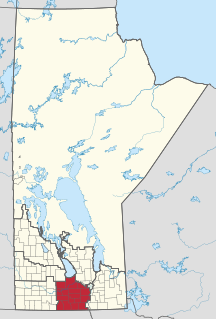
Census Division No. 9 is a census division located within the Central Plains Region of the Province of Manitoba, Canada. Unlike in some other provinces, census divisions do not reflect the organization of local government in Manitoba. These areas exist solely for the purposes of statistical analysis and presentation; they have no government of their own.
Census Division No. 18 is a census division located within the Interlake Region of the province of Manitoba, Canada. Unlike in some other provinces, census divisions do not reflect the organization of local government in Manitoba. These areas exist solely for the purposes of statistical analysis and presentation; they have no government of their own.
Census Division No. 17 (Dauphin) is a census division located within the Parklands Region of the province of Manitoba, Canada. Unlike in some other provinces, census divisions do not reflect the organization of local government in Manitoba. These areas exist solely for the purposes of statistical analysis and presentation; they have no government of their own.
The Rural Municipality of South Norfolk is a former rural municipality (RM) in the Canadian province of Manitoba. It was originally incorporated as a rural municipality on December 22, 1883. It ceased on January 1, 2015 as a result of its provincially mandated amalgamation with the Town of Treherne to form the Municipality of Norfolk Treherne.
Rathwell is an unincorporated urban centre in the province of Manitoba. It is part of the agricultural area of south central Manitoba, Canada and is situated in the Municipality of Norfolk Treherne.

Sandy Bay is a northern village in Saskatchewan, Canada. It is located 190 km northwest of Creighton via the Hanson Lake Road and Highway 135. The community is on the banks of the Churchill River. It is at the end of Highway 135, after passing through Pelican Narrows. Sandy Bay is 72 km north of Pelican Narrows. Pelican Narrows, the neighbouring community, is the administrative centre for the Peter Ballantyne Cree Nation and the majority of the townsite is reserve land. Sandy Bay is split into two parts: the southern village part and the northern part, which is situated on the Wapaskokimaw reserve.
Sandy Bay First Nation is an Ojibway/mixed-blood First Nation in Manitoba, Canada. As of the 2016 Canadian Census, it had a population of 2,515; while the First Nation's website reports a membership of 6,776 individuals as of April 2018.

The Boyne River is a river in the Hudson Bay drainage basin in the Central Plains and Pembina Valley Regions of Manitoba, Canada.
The Prairie Mountain Health is the governing body responsible for healthcare delivery and regulation for the eponymous health region in southwest Manitoba.
Dakota Plains First Nation or Wakhpetunwin Otinta is a First Nations entity southwest of Portage la Prairie, Manitoba. It borders the somewhat larger Long Plain First Nation, as well as the Rural Municipality of Portage la Prairie and the Municipality of Norfolk Treherne.


