This article needs additional citations for verification .(October 2011) |


Elapeedika is a village in the southwestern state of Kerala, India.
This article needs additional citations for verification .(October 2011) |
Elapeedika is a village in the southwestern state of Kerala, India.
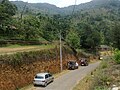
Elapeedika is situated around 1000 m above sea level, in the Western Ghats range of mountains. It is a hill station.
The name Elapeedika is derived from the words elam ("cardamom") and peedika ("shop"). There was a lot of cardamom plantation in the olden times. During the foreign rule, the cardamom produced in Wayanad was brought and stored in this area located in the valley of Wayanad for export to foreign countries. So the place where cardamom was sold was called Elapeedika, which became the name of the place.
Pazhassiraja's force and East India Company fought a battle in the 18th century at the Periya pass in Elapeedika.
The national highway passes through Kannur town. Mangalore and Mumbai can be accessed on the northern side and Cochin and Thiruvananthapuram can be accessed on the southern side. The road to the east of Iritty connects to Mysore and Bangalore. The nearest railway station is Kannur on Mangalore-Palakkad line. There are airports at Mangalore and Calicut.
Elapeedika is situated near Kolakkad at Peravoor in Iritty Taluk, Kannur district, Kerala state, India. It is the highest place in Kannur District. [1] One can see the whole area of Kannur district and Arabian Sea from here.[ citation needed ]
It has a Roman Catholic church dedicated to St Sebastian [2] and it is the highest church from sea level in Kannur District.


Iritty is a municipality and taluk of Kannur district in Kerala state, India. The town is the main market place for the farmer communities in the surrounding regions. Iritty is at a distance of 20 km (12 mi) from Kannur International Airport and one among five taluks in Kannur district. Iritty is one of the major towns lies between Coorg and Kannur international airport near Mattanur.
Padiyoor is a small town in Kannur district of Kerala state, India. Padiyoor village is part of Padiyoor-Kalliad Grama Panchayat in Iritty taluk.

Peravoor is a town and grama panchayat in Kannur district of Kerala state in India. It is located 50 km (31 mi) east of Kannur and 40 km (25 mi) north east of Thalassery. Iritty, the nearest municipality, is 14 km (8.7 mi) north of Peravoor. Peravoor is situated in the Western Ghats mountain range.

Ulikkal is a small town in Kannur district of Kerala state, India. It is the HQ of Ulikkal Grama Panchayat in Iritty taluk. Kerala State Hill highway SH 59 passes through Ulikkal town. Ulikkal Panchayat borders Kodagu district of Karnataka in the east, adjacent to Kalanki hill station.
Peringathur is a census town in Thalassery taluk of Kannur district in the Indian state of Kerala. It is a part of the municipality of Panoor.

Sreekandapuram is a municipality in Kannur district of the Indian state of Kerala.
Kelakam is a small town and Grama Panchayat located in Kannur district of Kerala state, India. Kerala Hill Highway and the proposed Mananthavady Mattanur airport road passes through Kelakam town.
Blathur is a village in Kannur, Kerala, India, located approximately 38 kilometres north-east of the district headquarters, Kannur. The nearest town, Irikkur, is estimated to be 7 kilometres from the village itself. Blathur is situated in the Padiyoor Grama Panchayat in Iritty Taluk, on the edge of an estimated 90 acre paddy field, and is 169 meters above sea level. The area is rich in laterite rocks, and the main industry is based on laterite stone mining and agriculture.

Cherupuzha is a town in Kannur district, Kerala, India. It is the headquarters of the Cherupuzha Panchayat which is a special grade panchayat in Kerala.
Karikkottakary is a small town located 12 km (7.5 mi) east of Iritty in Kannur district, Kerala state. Karikkotakari revenue village is formed on 26th February 2021 by trifurcating Aralam and Ayyankunnu villages.
Edoor is a small town about 6.5 kilometers from Iritty in Kannur district in Kerala, India. Edoor is named by the people from travancore. Before their migration these lands were forest

Aralam is a village and Grama Panchayat in Kannur district in the Indian state of Kerala.

Kanichar is a village and Grama Panchayat in Kannur district in the Indian state of Kerala.

Manathana is a village in Peravoor Grama Panchayat of Kannur district, Kerala, India.
Tholambra is a village in Kannur district in the Indian state of Kerala. The Maloor police station is situated in Tholambra village.
Vekkalam is a revenue village located in Kannur district in Kerala, India.
Velimanam is a small village 12 km from Iritty, a migrant hub in Kannur district, Kerala, India.
Malayampadi is a small village in Kannur District of Kerala, India. The village is located on the slope of the Western Ghats 1302 feet above sea level. The name Malayampadi originated from Malonpadi, malon the tribal god of kurichya and padi means step, literally the temple of malon.
Kannur, India has a number of tourist attractions including beaches, hills, temples and other monuments.

Ambayathode is a village near the famous Kottiyoor temple town in Kannur district of Kerala province in India. Ambayathodu witnessed massive landslides during Kerala Floods 2018.
The highest place in the district is Elapeedika (2,500 - 3,200 ft.)