Fort William (federal electoral district)

Last updated

Fort William
Flag of Ontario.svg Ontario electoral district
Defunct federal electoral district
Legislature House of Commons
District created1924
District abolished1976
First contested 1925
Last contested 1974

Fort William was a federal electoral district represented in the House of Commons of Canada from the year 1925 to 1979. It was located in the province of Ontario. This riding was created in 1924 from parts of Fort William and Rainy River riding.

Contents

It was initially defined to consist of the southern parts of the territorial districts of Rainy River, Kenora and Thunder Bay adjacent to the southern boundary of Canada.

In 1947, it was defined to consist of the city of Fort William and the southern parts of the territorial districts of Rainy River, Kenora and Thunder Bay adjacent to by the southern boundary of Canada.

In 1966, it was defined to consist of the City of Fort William and the Townships of Aldina, Blake, Crooks, Devon, Fraleigh, Gillies, Hartington, Lismore, Lybster, Marks, Neebing, O'Connor, Paipoonge, Pardee, Pearson, Scoble and Strange in the territorial district of Thunder Bay.

The electoral district was abolished in 1976 when it was merged into Thunder Bay—Atikokan riding.

History

S.C. 1924, c.63

Consisting of those parts of the territorial districts of Rainy River, Kenora and Thunder Bay bounded on the south by the southern boundary of Canada, and on the west, north and east by a line described as commencing on the said southern boundary at the intersection of the fifth meridian passing between the townships of Melgund and Revell; thence north along the said meridian to a point five miles north of the Canadian Pacific Railway; thence southeast parallel to and at a distance of five miles northerly from the said line of railway to a point five miles due north of the station of Poland, south to the said railway and continuing along the same to the intersection of the projection westerly to the north boundary of the township of Forbes; thence along the north and east boundaries of the said township, the north and east boundaries of the townships of Conmee and Oliver, and the north boundary of the townships of Paipoonge and Neebing, and their projection easterly to the eighty-ninth meridian; thence along the said meridian to the southern boundary of Canada.

S.C. 1933, c.54

Consisting of those parts of the territorial districts of Rainy River, Kenora and Thunder Bay bounded on the south by the southern boundary of Canada, on the west by the Fourth Meridan and on the north and east by a line described as commencing at a point on the said Fourth Meridian five miles north of the Canadian Pacific Railway; thence southeast parallel to and at a distance of five miles northerly from the said line of railway to a point five miles due north of the station of Poland; thence south to the said railway and continuing along the said railway to the intersection of the north boundary of the township of Goldie; thence along the north boundaries of the townships of Goldie and Forbes; thence south along the east boundaries of the townships of Forbes and Conmee; thence east and south along the north and east boundaries respectively of the township of Oliver; thence along the north boundaries of the townships of Paipoonge and Neebing and their projection easterly to the Eighty-ninth Meridian; thence south along the said meridian to the southern boundary of Canada.

S.C. 1947, c.71

Consisting of the city of Fort William and of those parts of the territorial districts of Rainy River, Kenora and Thunder Bay bounded on the south by the southern boundary of Canada; on the west by the Fourth Meridian; (excluding Atikokan Improvement District) and on the north and east by a line described as commencing at a point on the said Fourth Meridian five miles north of the Canadian Pacific Railway; thence southeast parallel to and at a distance of five miles northerly from the said line of railway to a point five miles due north of the former station of Poland, which was situated approximately at the intersection of the said railway line with the north boundary of the township of Fallis, five and one half miles westerly from Argon station; thence south to the said railway and continuing along the said railway to the intersection of the north boundary of the township of Goldie; thence along the north boundaries of the townships of Goldie and Forbes; thence south along the east boundaries of the townships of Forbes and Conmee; thence east and south along the north and east boundaries respectively of the township of Oliver; thence along the north boundaries of the townships of Paipoonge and Neebing and their prolongation easterly to the Eighty-ninth Meridian of west longitude; thence south along the said Meridian to the southern boundary of Canada.

S.C. 1952, c.48

Consisting of the city of Fort William and of those parts of the territorial districts of Rainy River, Kenora and Thunder Bay bounded on the south by the southern boundary of Canada; on the west by the Fourth Meridian; (excluding Atikokan Improvement District) and on the north and east by a line described as commencing at a point on the said Fourth Meridian five miles north of the Canadian Pacific Railway; thence southeast parallel to and at a distance of five miles northerly from the said line of railway to a point five miles due north of the former station of Poland, which was situated approximately at the intersection of the said railway line with the north boundary of the township of Fallis, five and one half miles westerly from Argon station; thence south to the said railway and continuing along the said railway to the intersection of the north boundary of the township of Goldie; thence along the north boundaries of the townships of Goldie and Forbes; thence south along the east boundaries of the townships of Forbes and Conmee; thence east and south along the north and east boundaries respectively of the township of Oliver; thence along the north boundaries of the townships of Paipoonge and Neebing and their prolongation easterly to the Eighty-ninth Meridian of west longitude; thence south along the said Meridian to the southern boundary of Canada.

Representation Order, 1966

Consisting of that part of the territorial district of Thunder Bay contained in the City of Fort William and the Townships of Aldina, Blake, Crooks, Devon, Fraleigh, Gillies, Hartington, Lismore, Lybster, Marks, Neebing, O'Connor, Paipoonge, Pardee, Pearson, Scoble and Strange. [1]

Members of Parliament

This riding has elected the following members of Parliament:

ParliamentYearsMemberParty
Riding created from Fort William and Rainy River
15th  1925–1926   Robert James Manion Conservative
16th  1926–1930
17th  1930–1930
 1930–1935
18th  1935–1940   Dan McIvor Liberal
19th  1940–1945
20th  1945–1949
21st  1949–1953
22nd  1953–1957
23rd  1957–1958
24th  1958–1962 Hubert Badanai
25th  1962–1963
26th  1963–1965
27th  1965–1968
28th  1968–1972
29th  1972–1974 Paul McRae
30th  1974–1979
Riding dissolved into Thunder Bay—Atikokan

Election results

1925 Canadian federal election
PartyCandidateVotes
Conservative Hon. Robert James Manion 6,205
Liberal DeWitt Clinton Garver2,830
1926 Canadian federal election
PartyCandidateVotes
Conservative Hon. Robert James Manion 5,173
Labour William Nassau Welsh2,440
1930 Canadian federal election
PartyCandidateVotes
Conservative Hon. Robert James Manion 6,939
Liberal Charles White Wilson3,262
Independent Albert Edward Smith594

On Mr. Manion being named Minister of Railways and Canals, 7 August 1930:

Canadian federal by-election, 25 August 1930
PartyCandidateVotes
Conservative Hon. Robert James Manion acclaimed
1935 Canadian federal election
PartyCandidateVotes
Liberal Daniel McIvor 5,481
Conservative Hon. Robert James Manion 4,565
Reconstruction Clement Edward Chapple2,030
Co-operative Commonwealth Garfield Anderson 1,635
Independent John Joseph Spooner78
1940 Canadian federal election
PartyCandidateVotes
Liberal Daniel McIvor 8,504
National Government Hon. Robert James Manion 6,768
Co-operative Commonwealth Garfield Anderson 1,778
1945 Canadian federal election
PartyCandidateVotes
Liberal Daniel McIvor 7,209
Co-operative Commonwealth Wilfred Carson McKenzie5,858
Progressive Conservative Robert Barclay Pow 4,945
Labor–Progressive Donald Stewart772
1949 Canadian federal election
PartyCandidateVotes
Liberal Daniel McIvor 9,569
Progressive Conservative J. Mac Spence5,751
Co-operative Commonwealth Garfield Anderson 4,830
Labor–Progressive Alvin L. Johnson746
1953 Canadian federal election
PartyCandidateVotes
Liberal Daniel McIvor 10,402
Progressive Conservative Murray Babe5,030
Co-operative Commonwealth William Johnson3,847
Labor–Progressive Naomi Mara Powell508
1957 Canadian federal election
PartyCandidateVotes
Liberal Daniel McIvor 8,552
Progressive Conservative Art Widnall7,926
Co-operative Commonwealth Michael Chicorli5,903
1958 Canadian federal election
PartyCandidateVotes
Liberal Hubert Badanai 9,915
Progressive Conservative Art Widnall9,798
Co-operative Commonwealth Michael Chicorli4,953
Labor–Progressive Bruce Magnuson 224
1962 Canadian federal election
PartyCandidateVotes
Liberal Hubert Badanai 12,229
Progressive Conservative Bernard Black
New Democratic Edward G. Freeman 5,713
Social Credit Arthur W. Hutton361
1963 Canadian federal election
PartyCandidateVotes
Liberal Hubert Badanai 11,765
New Democratic Edward G. Freeman 7,619
Progressive Conservative Ben Devlin6,618
Social Credit Arthur W. Hutton309
1965 Canadian federal election
PartyCandidateVotes
Liberal Hubert Badanai 12,432
New Democratic Charles A. Grant8,993
Progressive Conservative Ben Devlin4,773
1968 Canadian federal election
PartyCandidateVotes
Liberal Hubert Badanai 10,635
New Democratic Charles A. Grant7,394
Progressive Conservative Lionel Hastings7,284
1972 Canadian federal election
PartyCandidateVotes
Liberal Paul McRae 11,545
Progressive Conservative Lionel Hastings10,263
New Democratic Ian Stewart7,497
1974 Canadian federal election
PartyCandidateVotes
Liberal Paul McRae 13,789
New Democratic Ty Kaipio8,094
Progressive Conservative Lawrence Timko6,129
Communist Bruce Barrett149
Marxist–Leninist Dianne Robinson72

See also

Related Research Articles

<span class="mw-page-title-main">Fort William, Ontario</span> Former city in Ontario

Fort William was a city in Ontario, Canada, located on the Kaministiquia River, at its entrance to Lake Superior. It amalgamated with Port Arthur and the townships of Neebing and McIntyre to form the city of Thunder Bay in January 1970. Since then, it has been the largest city in Northwestern Ontario. The city's Latin motto was A posse ad esse, featured on its coat of arms designed in 1900 by town officials, "On one side of the shield stands an Indian dressed in the paint and feathers of the early days; on the other side is a French voyageur; the cent[re] contains a grain elevator, a steamship and a locomotive, while the beaver surmounts the whole."

<span class="mw-page-title-main">Thunder Bay District</span> District in Ontario, Canada

Thunder Bay District is a district and census division in Northwestern Ontario in the Canadian province of Ontario. The district seat is Thunder Bay.

<span class="mw-page-title-main">Timmins—James Bay (federal electoral district)</span> Federal electoral district in Ontario, Canada

Timmins—James Bay is a federal electoral district in Ontario, Canada, that has been represented in the House of Commons of Canada since 1997. Its population in 2011 was 83,104.

<span class="mw-page-title-main">Northwestern Ontario</span> Secondary region in Ontario, Canada

Northwestern Ontario is a secondary region of Northern Ontario in the Canadian province of Ontario which lies north and west of Lake Superior and west of Hudson Bay and James Bay. It includes most of subarctic Ontario. Its western boundary is the Canadian province of Manitoba, which disputed Ontario's claim to the western part of the region. Ontario's right to Northwestern Ontario was determined by the Judicial Committee of the Privy Council in 1884 and confirmed by the Canada Act, 1889, of the Parliament of the United Kingdom. In 1912, the Parliament of Canada by the Ontario Boundaries Extension Act gave jurisdiction over the District of Patricia to Ontario, thereby extending the northern boundary of the province to Hudson Bay.

<span class="mw-page-title-main">Oliver Paipoonge</span> Municipality in Ontario, Canada

Oliver Paipoonge is a township in the Canadian province of Ontario, located directly west of the city of Thunder Bay. The municipality was formed on January 1, 1998, with the amalgamation of the former Township of Oliver and Township of Paipoonge. It contains several communities within its boundaries, including Baird, Carters Corners, Harstone, Kakabeka Falls, Lee, McCluskeys Corners, Millar, Murillo, Rosslyn, Slate River Valley, Stanley and Twin City. The remainder of the municipality is agricultural or rural.

<span class="mw-page-title-main">Fort Frances</span> Town in Ontario, Canada

Fort Frances is a town in, and the seat of, Rainy River District in Northwestern Ontario, Canada. The population as of the 2021 census was 7,466 Fort Frances is a popular fishing destination. It hosts the annual Fort Frances Canadian Bass Championship.

Antigonish was a federal electoral district in Nova Scotia, Canada, that was represented in the House of Commons of Canada from 1867 to 1917. It was created in the British North America Act, 1867. The federal riding was dissolved in 1914 into the riding of Antigonish—Guysborough. It consisted of the County of Antigonish.

<span class="mw-page-title-main">Kenora (federal electoral district)</span> Federal electoral district in Ontario, Canada

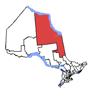
Kenora is a federal electoral district in Ontario, Canada, that has been represented in the House of Commons of Canada since 2004.

<span class="mw-page-title-main">Sault Ste. Marie (federal electoral district)</span> Federal electoral district in Ontario, Canada

Sault Ste. Marie is a federal electoral district in Ontario, Canada, that has been represented in the House of Commons of Canada since 1968.

<span class="mw-page-title-main">Thunder Bay—Rainy River</span> Federal electoral district in Ontario, Canada

Thunder Bay—Rainy River is a federal electoral district in Ontario, Canada, that has been represented in the House of Commons of Canada since 2004. It first elected a member in the 2004 federal election.

<span class="mw-page-title-main">Thunder Bay—Superior North (federal electoral district)</span> Federal electoral district in Ontario, Canada

Thunder Bay—Superior North is a federal electoral district in Ontario, Canada, that has been represented in the House of Commons of Canada since 1976.

Kenora—Rainy River was a federal electoral district represented in the House of Commons of Canada from 1925 to 2004. It was located in the province of Ontario. This riding was created in 1924 from parts of Fort William and Rainy River and Port Arthur and Kenora ridings.

Cochrane was a federal electoral district in the province of Ontario, Canada. It was represented in the House of Commons of Canada from 1935 to 1997.

Port Arthur was a federal electoral district represented in the House of Commons of Canada from 1935 to 1979. It was located in the province of Ontario. This riding was created in 1933 from parts of Port Arthur—Thunder Bay riding.

Thunder Bay was an electoral district in the northwestern part of the province of Ontario, Canada, that was represented in the House of Commons of Canada from 1968 to 1979, and the Legislative Assembly of Ontario until 1975.

<span class="mw-page-title-main">Kenora—Rainy River (provincial electoral district)</span> Provincial electoral district in Ontario, Canada

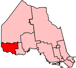
Kenora—Rainy River is a provincial electoral district (riding) in northwestern Ontario, Canada, that has been represented in the Legislative Assembly of Ontario since 1999. It was created from Kenora, most of Rainy River and part of Lake Nipigon. The boundaries of the new district corresponded with the Kenora—Rainy River federal riding, until it was abolished in 2003. The provincial riding will continue to exist.

<span class="mw-page-title-main">Thunder Bay—Superior North (provincial electoral district)</span> Provincial electoral district in Ontario, Canada

Thunder Bay—Superior North is a provincial electoral district in Ontario, Canada, that has been represented in the Legislative Assembly of Ontario since 1999.

<span class="mw-page-title-main">Timmins—James Bay (provincial electoral district)</span> Provincial electoral district in Ontario, Canada

Timmins—James Bay was a provincial electoral district in Ontario, Canada, that was represented in the Legislative Assembly of Ontario from 1999 to 2018. Its population in 2001 was 84,001.

King's Highway 130, commonly known as Highway 130, is a provincially maintained highway in the Canadian province of Ontario. It begins at a junction with Highway 61 and travels 15.4 km (9.6 mi) north-west to the Trans-Canada Highway, Highway 11 and Highway 17, west of Thunder Bay. Highway 130 is a short connecting highway, and passes entirely through the outskirts of Thunder Bay, connecting several minor communities and providing a shortcut for traffic travelling from the south to the west or vice versa. The speed limit along the highway is 80 km/h (50 mph); it is patrolled by the Ontario Provincial Police.

References

  1. "Profile".