
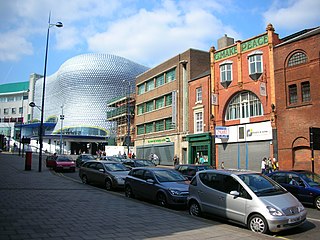
The Bull Ring is a major shopping area in central Birmingham England, and has been an important feature of Birmingham since the Middle Ages, when its market was first held. Two shopping centres have been built in the area; in the 1960s, and then in 2003; the latter is styled as one word, Bullring. When coupled with Grand Central it forms the United Kingdom's largest city centre based shopping centre, styled as Bullring & Grand Central.
Digbeth is an area of central Birmingham, England. Following the remodelling of the Inner Ring Road, Digbeth is now considered a district within Birmingham City Centre. As part of the Big City Plan, Digbeth is undergoing a large redevelopment scheme that will regenerate the old industrial buildings into apartments, retail premises, offices and arts facilities. The district is considered to be Birmingham's "Creative Quarter".

Stirchley is a suburb in south-west Birmingham, England. The name likely refers to a pasture for cattle. The settlement dates back to at least 1658. Prehistoric evidence, Roman roads, and Anglo-Saxon charters contribute to its history. The Worcester and Birmingham Canal and the railways brought industry to the area. Stirchley's development is also linked to industries like screw-making and rubber manufacturing. Originally part of Worcestershire, Stirchley underwent administrative changes in 1911. Residential developments were established alongside the long-standing Victorian terracing which is associated with the suburb.

Carl Steven Alfred Chinn is an English historian, author and radio presenter whose working life has been devoted to the study and popularisation of the city of Birmingham. He broadcast a programme on the BBC from the mid-1990s focusing on Birmingham's history.

The Bartons Arms is a public house in the High Street in the Newtown area of Aston, Birmingham, England. Under new management as of August 2024.

Nechells is a district ward in central Birmingham, England, whose population in 2011 was 33,957. It is also a ward within the formal district of Ladywood. Nechells local government ward includes areas, for example parts of Birmingham city centre, which are not part of the historic district of Nechells as such, now often referred to in policy documents as "North Nechells, Bloomsbury and Duddeston".

Masshouse is a development site in the Eastside area of Birmingham, England. Its name derives from a Roman Catholic Church built in 1687. Buildings were cleared to make way for the inner city ring road and car parking in the 1960s. Birmingham City Council wished to expand the city centre eastwards and an elevated road junction, Masshouse Circus was demolished in 2002 to facilitate redevelopment.

Eastside is a district of Birmingham City Centre, England that is undergoing a major redevelopment project. The overall cost when completed is expected to be £6–8 billion over ten years which will result in the creation of 12,000 jobs. 8,000 jobs are expected to be created during the construction period. It is part of the larger Big City Plan project.
Pype Hayes is a modern housing estate area and council ward in the east of the Erdington district of Birmingham. It was within the Tyburn ward until 2018. Covering the postcodes of B24 and B76.

High Speed 2 (HS2) is a high-speed railway which is under construction in England. The line will run between Handsacre, in southern Staffordshire, and London, with a spur to Birmingham. HS2 is to be Britain's second purpose-built high-speed railway after High Speed 1, which connects London to the Channel Tunnel. London and Birmingham will be served directly by new high speed track, and services to Glasgow, Liverpool and Manchester will use a mix of new high speed track and the existing West Coast Main Line. The majority of the project is planned to be completed by 2033.
This article is intended to show a timeline of events in the History of Birmingham, England, with a particular focus on the events, people or places that are covered in Wikipedia articles.

Birmingham city centre, also known as Central Birmingham, is the central business district of Birmingham, England. The area was historically in Warwickshire. Following the removal of the Inner Ring Road, the city centre is now defined as being the area within the Middle Ring Road. The city centre is undergoing massive redevelopment with the Big City Plan, which means there are now nine emerging districts and the city centre is approximately five times bigger.

Island House was a locally listed building in Birmingham's Eastside area, with a roughly triangular footprint. It was built in 1912 by the architect G. E. Pepper, in the Edwardian Mannerist style, ornately decorated with both Ionic and Doric decorations. Originally it was designed to be used as office building and warehouse for the prominent “Messrs Churchill & Co” machine tool company. The opening ceremony of Island House was held in 1913.

Birmingham Curzon Street railway station is the planned northern terminus of High Speed 2 on the fringe of Birmingham city centre, England. The new railway will connect Birmingham to London Euston via Birmingham Interchange and Old Oak Common. Curzon Street will have seven terminal platforms and was planned to open in 2026, though delays have pushed this back to 2028.

Northfield Manor House is a Manor House, on Bristol Road South, Northfield, Birmingham, England. It was formerly known as Manor Farm, and under that name was home to George and Elizabeth Cadbury.

The Peaky Blinders were a street gang based in Birmingham, England, which operated from the 1880s until the 1920s. The group consisted largely of young criminals from lower- to working-class backgrounds. They engaged in robbery, violence, racketeering, illegal bookmaking, and control of gambling. Members wore signature outfits that typically included tailored jackets, lapelled overcoats, buttoned waistcoats, silk scarves, bell-bottom trousers, leather boots, and peaked flat caps. Contrary to the television series of the same name, it is unlikely that they had razor blades sewn into these caps, instead gaining their name from the way they wore them with the cap tilted so that the peak covered one eye.

The Woodman is a pub in the Digbeth area of Birmingham, England. It is located on the corner of New Canal Street and what was formerly part of Albert Street, now part of an urban park called Eastside City Park and is Grade II listed. After an extended period of closure owing to the COVID-19 pandemic and the development of an HS2 rail scheme, the pub reopened on 13 September 2024.

The Public Office was a municipal building on Moor Street in Birmingham, England, built between 1805 and 1807. It was the first important administrative building in Birmingham, and remained the principal local government centre until the 1880s, when the much larger Council House was constructed. The building was demolished in 1911 to make way for a railway goods station.


