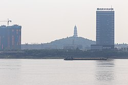
Gaoyao 高要区 Koyiu | |
---|---|
Coordinates: 23°02′N112°27′E / 23.033°N 112.450°E | |
Country | People's Republic of China |
Province | Guangdong |
Prefecture-level city | Zhaoqing |
Area | |
• Total | 2,206 km2 (852 sq mi) |
Population (2020 census) | |
• Total | 741,591 |
• Density | 340/km2 (870/sq mi) |
Time zone | UTC+8 (China Standard) |
Gaoyao, Zhaoqing | |||||||||||
---|---|---|---|---|---|---|---|---|---|---|---|
Chinese | 高要 | ||||||||||
Postal | Koyiu | ||||||||||
|
Gaoyao,alternately romanized as Koyiu,is an urban district of Zhaoqing in western Guangdong,China. Its population in 2020 was 741,591. [1]
Gaoyao (lit. 'high and wanting') is a former name of the Lingyang Gorge on the Xi River. It was originally the name of the surrounding land but came to be used for the area's seat of government. Gaoyao is the pinyin romanization of the Chinese name,based on its Mandarin pronunciation;the former Chinese Postal Map spelling was based on the local Cantonese pronunciation of the same name. Gaoyao has also sometimes been romanized as Kaou Yaou. [2]
Gaoyao is located on the southern bank of the Xi River,opposite central Zhaoqing. Both are about 100 kilometers (62 mi) away from Guangzhou,the provincial capital.
Climate data for Gaoyao (1991–2020 normals,extremes 1981–2010) | |||||||||||||
---|---|---|---|---|---|---|---|---|---|---|---|---|---|
Month | Jan | Feb | Mar | Apr | May | Jun | Jul | Aug | Sep | Oct | Nov | Dec | Year |
Record high °C (°F) | 28.3 (82.9) | 31.4 (88.5) | 32.4 (90.3) | 34.4 (93.9) | 34.9 (94.8) | 37.9 (100.2) | 38.5 (101.3) | 38.1 (100.6) | 36.9 (98.4) | 35.8 (96.4) | 33.1 (91.6) | 30.0 (86.0) | 38.5 (101.3) |
Mean daily maximum °C (°F) | 18.9 (66.0) | 20.9 (69.6) | 23.5 (74.3) | 27.9 (82.2) | 31.3 (88.3) | 33.2 (91.8) | 34.2 (93.6) | 33.9 (93.0) | 32.3 (90.1) | 29.6 (85.3) | 25.6 (78.1) | 20.8 (69.4) | 27.7 (81.8) |
Daily mean °C (°F) | 13.9 (57.0) | 16.0 (60.8) | 19.2 (66.6) | 23.4 (74.1) | 26.5 (79.7) | 28.2 (82.8) | 28.9 (84.0) | 28.6 (83.5) | 27.2 (81.0) | 24.2 (75.6) | 19.9 (67.8) | 15.2 (59.4) | 22.6 (72.7) |
Mean daily minimum °C (°F) | 10.6 (51.1) | 12.7 (54.9) | 16.1 (61.0) | 20.3 (68.5) | 23.3 (73.9) | 25.1 (77.2) | 25.6 (78.1) | 25.3 (77.5) | 23.9 (75.0) | 20.3 (68.5) | 16.0 (60.8) | 11.5 (52.7) | 19.2 (66.6) |
Record low °C (°F) | 3.1 (37.6) | 3.9 (39.0) | 6.1 (43.0) | 10.7 (51.3) | 16.8 (62.2) | 20.4 (68.7) | 22.9 (73.2) | 22.6 (72.7) | 18.8 (65.8) | 13.4 (56.1) | 5.3 (41.5) | 1.7 (35.1) | 1.7 (35.1) |
Average precipitation mm (inches) | 51.8 (2.04) | 43.9 (1.73) | 76.2 (3.00) | 130.3 (5.13) | 189.2 (7.45) | 212.3 (8.36) | 189.1 (7.44) | 188.8 (7.43) | 150.6 (5.93) | 56.6 (2.23) | 41.9 (1.65) | 37.8 (1.49) | 1,368.5 (53.88) |
Average precipitation days (≥0.1 mm) | 7.9 | 10.3 | 14.8 | 14.9 | 18.0 | 19.7 | 16.8 | 16.0 | 11.8 | 5.0 | 5.5 | 5.9 | 146.6 |
Average relative humidity (%) | 78 | 79 | 81 | 80 | 81 | 81 | 79 | 80 | 79 | 75 | 75 | 75 | 79 |
Mean monthly sunshine hours | 99.7 | 75.9 | 58.2 | 77.2 | 124.5 | 147.0 | 191.8 | 183.8 | 173.3 | 182.9 | 156.3 | 140.5 | 1,611.1 |
Percent possible sunshine | 30 | 24 | 16 | 20 | 30 | 36 | 46 | 46 | 47 | 51 | 48 | 42 | 36 |
Source:China Meteorological Administration [3] [4] |
Gaoyao was a county of the Qin and Han and its eponymous county seat was the principal settlement of the area. Under the Sui,the administration relocated across the river to Duanzhou,which was renamed Zhaoqing under the Song. Gaoyao continued as a separate county in Zhaoqing Commandery. [2] It was promoted to a county-level city in 1993 and later to urban district status.
Notable figures include:
Places of interest include the Red Mansion and Gaoyao Xuegong Pavilion. There are also three pagodas that can be seen in Gaoyao.
Gaoyao has jurisdiction over one subdistrict and several towns:
Name | Chinese (S) | Hanyu Pinyin | Population (2010) [7] | Area (km2) |
---|---|---|---|---|
Nan'an Subdistrict | 南岸街道 | Nán'àn Jiēdào | 81,886 | 36.5 |
Hetai town | 河台镇 | Hétái Zhèn | 33,660 | 150 |
Lecheng town | 乐城镇 | Lèchéng Zhèn | 24,337 | 94 |
Shuinan town | 水南镇 | Shuǐnán Zhèn | 11,598 | 126 |
Lubu town (Lukpo) | 禄步镇 | Lùbù Zhèn | 63,488 | 254 |
Xiaoxiang town | 小湘镇 | Xiǎoxiāng Zhèn | 30,964 | 200 |
Dawan town | 大湾镇 | Dàwān Zhèn | 34,535 | 108 |
Xinqiao town | 新桥镇 | Xīnqiáo Zhèn | 39,265 | 41.8 |
Baizhu town | 白诸镇 | Báizhū Zhèn | 36,977 | 128 |
Liantang town | 莲塘镇 | Liántáng Zhèn | 58,429 | 125 |
Huodao town | 活道镇 | Huódào Zhèn | 41,358 | 228 |
Jiaotang town | 蛟塘镇 | Jiāotáng Zhèn | 33,060 | 130 |
Huilong town | 回龙镇 | Huílóng Zhèn | 25,426 | 124.25 |
Baitu town | 白土镇 | Báitǔ Zhèn | 71,430 | 108.4 |
Jindu town | 金渡镇 | Jīndù Zhèn | 43,623 | 101.23 |
Jinli town | 金利镇 | Jīnlì Zhèn | 93,792 | 141.3 |
Xiangang town | 蚬岗镇 | Xiǎngǎng Zhèn | 29,292 | 96.6 |
Zhaoqing, alternately romanized as Shiuhing, is a prefecture-level city in Guangdong Province, China. As of the 2020 census, its population was 4,113,594, with 1,553,109 living in the built-up area made of Duanzhou, Dinghu and Gaoyao. The prefectural seat—except the Seven Star Crags—is fairly flat, but thickly forested mountains lie just outside its limits. Numerous rice paddies and aquaculture ponds are found on the outskirts of the city. Sihui and the southern districts of the prefecture are considered part of the Pearl River Delta.
Shaoguan is a prefecture-level city in northern Guangdong Province (Yuebei), South China, bordering Hunan to the northwest and Jiangxi to the northeast. It is home to the mummified remains of the sixth Zen Buddhist patriarch Huineng. Its built-up area made up of Zhenjiang, Wujiang and Qujiang urban conurbated districts was home to 1,028,460 inhabitants as of the 2020 census.
Sihui, formerly romanized as Szewui, is a county-level city in the west of the Pearl River Delta region in Guangdong province, China. It is administered as part of the prefecture-level city of Zhaoqing. Sihui's population is 640,910 in 2020.
Lufeng, alternately romanized as Lukfung in Cantonese, is a county-level city in the southeast of Guangdong province, administered as a part of the prefecture-level city of Shanwei. It lies on the mainland on coast of the South China Sea east of Hong Kong.
Heshan, formerly romanized as Hokshan, is a county-level city of Jiangmen City in the southern part of Guangdong Province, China with a total land area of 1,081 square kilometres (417 sq mi) and a population of 530,684 inhabitants as of 2020 census and some 200,000 internal migrants. The city is now being conurbated with Jiangmen and so included in the Guangzhou-Shenzhen Pearl River conurbation with more than 65,57 million inhabitants. There are approximately 360,000 people of Heshan origin or descent living in other parts of the world, particularly in the Americas such as Chile, Peru and the United States.
Qingyuan, formerly romanized as Tsingyun, is a prefecture-level city in northern Guangdong province, China, on the banks of the Bei or North River. During the 2020 census, its total population was 3,969,473, out of whom 1,738,424 lived in the built-up area made of urbanized Qingcheng and Qingxin districts. The primary spoken language is Cantonese. Covering 19,015 km2 (7,342 sq mi), Qingyuan is Guangdong's largest prefecture-level division by land area, and it borders Guangzhou and Foshan to the south, Shaoguan to the east and northeast, Zhaoqing to the south and southwest, and Hunan province and Guangxi Zhuang Autonomous Region to the north. The urban core is surrounded by mountainous areas but is directly connected with Guangzhou and the Pearl River Delta by Highway 107.
Sanshui District, formerly romanized as Samshui, is an urban district of the prefecture-level city of Foshan in Guangdong province, China. It had a population of 622,645 as of the 2010 census. It is known for the "Samsui women", emigrants who labour in Singapore, and for a large fireworks explosion in 2008.
Enping, alternately romanized as Yanping, is a county-level city in Guangdong province, China, administered as part of the prefecture-level city of Jiangmen.
Yangjiang, alternately romanized via Cantonese as Yeungkong, is a prefecture-level city in southwestern Guangdong Province in the People's Republic of China. It borders Maoming to the west, Yunfu to the north, Jiangmen to the east, and looks out to the South China Sea to the south. The local dialect is the Gaoyang dialect, a branch of Yue Chinese. During the 2020 census, its population was 2,602,959 inhabitants of whom 1,292,987 lived in the built-up and largely urbanized area comprising Jiangcheng District and Yangdong County.
Huadu District is one of 11 urban districts of the prefecture-level city of Guangzhou, the capital of Guangdong, China. It is located in the far northern suburbs of the city.
Conghua District, alternately romanized as Tsungfa, is one of 11 urban districts and the northernmost district of the prefecture-level city of Guangzhou, the capital of Guangdong Province, China. Conghua connects the Pearl River Delta with the mountainous area of northern Guangdong. Within China, it is known for its hot springs and lychees. It covers an area of 1,974.15 km2 (762.22 sq mi), with a population of 543.377 in 2006. Its GDP was RMB10.369 billion.
Zengcheng District is one of 11 urban districts of the prefecture-level city of Guangzhou, the capital of Guangdong Province, China.
Deqing County, formerly romanized as Takhing, is a county in western Guangdong province, China, under the administration of the prefecture-level city of Zhaoqing.
Fengkai County is a county in western Guangdong Province, China, under the administration of the prefecture-level city of Zhaoqing. It was formed in 1961 from the merger of Fengchuan and Kaijian Counties, which were formerly romanized as Fungchuan and Hoikin respectively.
Guangning County, alternately romanized as Kwongning County, is a county in western Guangdong, China, under the administration of the prefecture-level city of Zhaoqing. Guangning County has an area of 2,380 square kilometers (920 sq mi), with a population of 408,112.
Huaiji County is a county of western Guangdong province, People's Republic of China. It is under the administration of Zhaoqing City.
Huiyang District (postal: Waiyeung; simplified Chinese: 惠阳区; traditional Chinese: 惠陽區; pinyin: Huìyáng Qū; Jyutping: wai6joeng4 keoi1 is a district of Huizhou, Guangdong province, People's Republic of China. It was renamed in 2003 amid the restructuring of districts and counties in Huizhou. Formerly named Huiyang city, its size shrank after the restructuring with several towns incorporated into the Huicheng district of Huizhou. Huiyang is the southern urban center of Huizhou along with Huicheng as the northern urban center.
Dianbai District, alternately romanized as Tinpak, is an urban district of the prefecture-level city of Maoming in southwestern Guangdong Province, China.
Yangchun, alternately romanized as Yeungchun, is a county-level city in southwestern Guangdong, China, administered as a part of the prefecture-level city of Yangjiang. Yangchun has an area of 4,055 km2 (1,566 sq mi) and had approximately 1.05 million inhabitants in 2003.
Xinxing County, alternately romanized as Sunhing, is a county of the prefecture-level city of Yunfu in the west of Guangdong province, China.