
Seine-Maritime is a department of France in the Normandy region of northern France. It is situated on the northern coast of France, at the mouth of the Seine, and includes the cities of Rouen and Le Havre. Until 1955 it was named Seine-Inférieure. It had a population of 1,255,633 in 2019.

The arrondissement of Le Havre is an arrondissement of France in the Seine-Maritime department in the Normandy region. It has 149 communes. Its population is 387,520 (2016), and its area is 1,221.2 km2 (471.5 sq mi).
Les Authieux-sur-le-Port-Saint-Ouen is a commune in the Seine-Maritime department in the Normandy region in northern France.
Gonneville-sur-Scie is a commune in the Seine-Maritime department in the Normandy region in northern France.

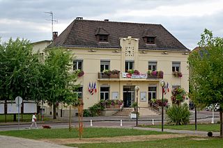
Criquetot-le-Mauconduit is a commune in the Seine-Maritime department in the Normandy region in northern France.
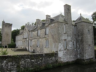
Crasville-la-Mallet is a commune in the Seine-Maritime department in the Normandy region in northern France.

Hénouville is a commune in the Seine-Maritime department in the Normandy region in northern France.

Le Bois-Robert is a commune in the Seine-Maritime department in the Normandy region in north-western France.

La Cerlangue is a commune in the Seine-Maritime department in the Normandy region in northern France.

Fontaine-le-Mallet is a commune in the Seine-Maritime department in the Normandy region in northern France.
Eslettes is a commune in the Seine-Maritime department in the Normandy region in northern France.
Le Trait is a commune in the Seine-Maritime department in the Normandy region in north-western France.

Torcy-le-Grand is a commune in the Seine-Maritime department in the Normandy region in northern France.
Torcy-le-Petit is a commune in the Seine-Maritime department in the Normandy region in north-western France.
The Canton of Saint-Valery-en-Caux is a canton situated in the Seine-Maritime département and in the Normandy region of northern France.
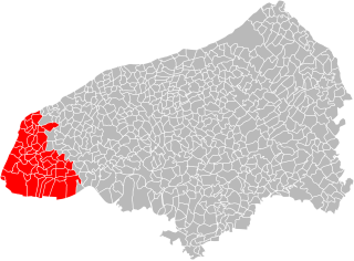
The Canton of Criquetot-l'Esneval is a former canton situated in the Seine-Maritime département and in the Haute-Normandie region of northern France. It was disbanded following the French canton reorganisation which came into effect in March 2015. It consisted of 21 communes, which joined the canton of Octeville-sur-Mer in 2015. It had a total of 16,394 inhabitants (2012).
The communauté de communes du Canton de Criquetot-l’Esneval is a former intercommunality in the Seine-Maritime département of the Normandy region of northern France. It was created on 28 December 2001. and it was merged into the new communauté urbaine Le Havre Seine Métropole on 1 January 2019.
Gonneville-le-Theil is a commune in the department of Manche, northwestern France. The municipality was established on 1 January 2016 by merger of the former communes of Gonneville and Le Theil.
The canton of Octeville-sur-Mer is an administrative division of the Seine-Maritime department, in northern France. It was created at the French canton reorganisation which came into effect in March 2015. Its seat is in Octeville-sur-Mer.
Le Havre Seine Métropole is the communauté urbaine, an intercommunal structure, centred on the city of Le Havre. It is located in the Seine-Maritime department, in the Normandy region, northwestern France. It was created on 1 January 2019 by the merger of the former Agglomeration community of Le Havre and the communautés de communes Canton de Criquetot-l'Esneval and Caux Estuaire. Its area is 495.8 km2. Its population was 268,912 in 2018, of which 169,733 in Le Havre proper.


