Pavilly

Last updated
Pavilly
Pavilly.jpg
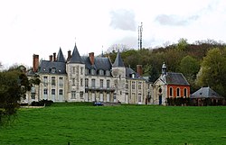
The castle Château d'Esneval
Blason Pavilly.svg
Pavilly
Location of Pavilly
France location map-Regions and departements-2016.svg
Red pog.svg
Pavilly
Normandie region location map.svg
Red pog.svg
Pavilly
Coordinates: 49°34′09″N0°57′16″E / 49.5692°N 0.9544°E / 49.5692; 0.9544
Country France
Region Normandy
Department Seine-Maritime
Arrondissement Rouen
Canton Notre-Dame-de-Bondeville
Government
  Mayor (20202026) François Tierce [1]
Area
1
14.19 km2 (5.48 sq mi)
Population
 (2023) [2]
6,029
  Density424.9/km2 (1,100/sq mi)
Time zone UTC+01:00 (CET)
  Summer (DST) UTC+02:00 (CEST)
INSEE/Postal code
76495 /76570
Elevation50–166 m (164–545 ft)
(avg. 102 m or 335 ft)
1 French Land Register data, which excludes lakes, ponds, glaciers > 1 km2 (0.386 sq mi or 247 acres) and river estuaries.

Pavilly (French pronunciation: [paviji] ) is a commune in the Seine-Maritime department in the Normandy region in northern France.

Contents

Geography

The settlement of Pavilly, a town of farming and light industry, is situated by the banks of the river Austreberthe in the Pays de Caux, some 12 miles (19 km) northwest of Rouen at the junction of the D4, D142, D22 and the D67 roads.

Heraldry

Arms of Pavilly Blason Pavilly.svg
Arms of Pavilly
The arms of Pavilly are blazoned  :
Quarterly 1: Azure, a cross fleurdelysée Or; 2: Sable, a crozier reversed Or, over which a wolf couchant argent; 3: Sable, a bee argent; and 4: paly Or and azure, a chief gules.


Population

Historical population
YearPop.±% p.a.
19685,024    
19755,593+1.54%
19825,442−0.39%
19905,729+0.64%
19996,140+0.77%
20076,056−0.17%
20126,235+0.58%
20176,308+0.23%
Source: INSEE [3]

Places of interest

People

See also

References

  1. Liste des maires du département de la Seine-Maritime, 10 August 2020
  2. "Populations de référence 2023" (in French). National Institute of Statistics and Economic Studies. 29 December 2025.
  3. Population en historique depuis 1968, INSEE