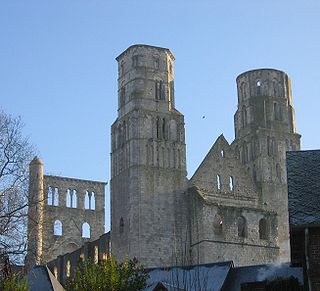
Jumièges is a commune in the Seine-Maritime department in the Normandy region in north-western France.

Berville-sur-Mer is a commune in the Norman department of Eure in northern France.
Mortemer is a commune in the Seine-Maritime department in the Normandy region in northern France.
Saint-Saëns is a commune in the Seine-Maritime department in the Normandy region in northern France. A small town of farming and associated light industry situated by the banks of the river Varenne in the Pays de Bray, some 19 miles (31 km) southeast of Dieppe at the junction of the D929, D12, D99 and the D154 roads. Junction 11 of the A28 autoroute with the A29 autoroute is within the commune's territory.
Saint-Maclou-de-Folleville is a commune in the Seine-Maritime department in the Normandy region in northern France.

Saint-Mards is a commune in the Seine-Maritime department in the Normandy region in northern France.

Saint-Paër is a commune in the Seine-Maritime department in the Normandy region in northern France.
Saint-Michel-d'Halescourt is a commune in the Seine-Maritime department in the Normandy region in northern France.

Pavilly is a commune in the Seine-Maritime department in the Normandy region in northern France.

Quevillon is a commune in the Seine-Maritime department in the Normandy region in northern France.

Osmoy-Saint-Valery is a commune in the Seine-Maritime department in the Normandy region in north-western France.
Saint-Germain-sur-Eaulne is a commune in the Seine-Maritime department in the Normandy region in northern France.

Saint-Laurent-de-Brèvedent is a commune in the Seine-Maritime department in the Normandy region in northern France.
Saint-Denis-d'Aclon is a commune in the Seine-Maritime department in the Normandy region in north-western France.
Saint-Denis-sur-Scie is a commune in the Seine-Maritime department in the Normandy region in northern France.
Saint-Aubin-sur-Scie is a commune in the Seine-Maritime department in the Normandy region in northern France.

Le Mesnil-sous-Jumièges is a commune in the Seine-Maritime department in the Normandy region in north-western France.

Saint-Pierre-le-Vieux is a commune in the Seine-Maritime department in the Normandy region in north-western France.
The Canton of Caudebec-en-Caux is a former canton situated in the Seine-Maritime département and in the Haute-Normandie region of northern France. It was disbanded following the French canton reorganisation which came into effect in March 2015. It consisted of 16 communes, which joined the canton of Notre-Dame-de-Gravenchon in 2015. It had a total of 14,128 inhabitants (2012).

The canton of Barentin is an administrative division of the Seine-Maritime department, in northern France. It was created at the French canton reorganisation which came into effect in March 2015. Its seat is in Barentin.


