Osmoy-Saint-Valery

Last updated
Osmoy-Saint-Valery
Osmoy-Saint-Valery.JPG
Notre-Dame church in Osmoy
Location of Osmoy-Saint-Valery
Osmoy-Saint-Valery
France location map-Regions and departements-2016.svg
Red pog.svg
Osmoy-Saint-Valery
Normandie region location map.svg
Red pog.svg
Osmoy-Saint-Valery
Coordinates: 49°47′50″N1°19′23″E / 49.7972°N 1.3231°E / 49.7972; 1.3231 Coordinates: 49°47′50″N1°19′23″E / 49.7972°N 1.3231°E / 49.7972; 1.3231
Country France
Region Normandy
Department Seine-Maritime
Arrondissement Dieppe
Canton Neufchâtel-en-Bray
Intercommunality CC de Londinières
Government
  Mayor (20202026) Marie-José Bourgeois [1]
Area
1
16.21 km2 (6.26 sq mi)
Population
 (Jan. 2019) [2]
314
  Density19/km2 (50/sq mi)
Time zone UTC+01:00 (CET)
  Summer (DST) UTC+02:00 (CEST)
INSEE/Postal code
76487 /76660
Elevation40–193 m (131–633 ft)
(avg. 56 m or 184 ft)
1 French Land Register data, which excludes lakes, ponds, glaciers > 1 km2 (0.386 sq mi or 247 acres) and river estuaries.

Osmoy-Saint-Valery is a commune in the Seine-Maritime department in the Normandy region in north-western France.

Contents

Geography

A farming village situated by the banks of the river Béthune in the Pays de Bray at the junction of the D 1 and the D 77 roads, some 15 miles (24 km) southeast of Dieppe.

History

Commune created in 1823 by the fusion of the three communes of Maintru, Osmoy and Saint-Valery-sous-Bures. [3]

Population

Historical population
YearPop.±% p.a.
1793 133    
1800 135+0.21%
1806 150+1.77%
1821 154+0.18%
1831 607+14.70%
1836 610+0.10%
1841 616+0.20%
1846 613−0.10%
1851 572−1.37%
1856 542−1.07%
1861 526−0.60%
1866 504−0.85%
1872 464−1.37%
1876 505+2.14%
1881 520+0.59%
1886 477−1.71%
1891 486+0.37%
1896 478−0.33%
YearPop.±% p.a.
1901 419−2.60%
1906 450+1.44%
1911 441−0.40%
1921 413−0.65%
1926 442+1.37%
1931 415−1.25%
1936 420+0.24%
1946 433+0.31%
1954 400−0.99%
1962 360−1.31%
1968 324−1.74%
1975 332+0.35%
1982 293−1.77%
1990 299+0.25%
1999 310+0.40%
2007 331+0.82%
2012 336+0.30%
2017 324−0.72%
Source: EHESS [3] and INSEE (1968-2017) [4]

Places of interest

See also

Related Research Articles

<span class="mw-page-title-main">Jumièges</span> Commune in Normandy, France

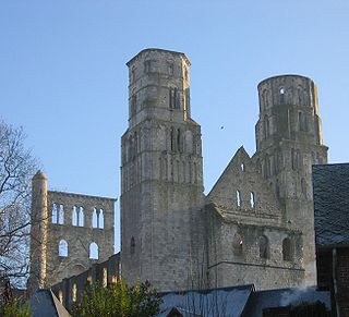
Jumièges is a commune in the Seine-Maritime department in the Normandy region in north-western France.

<span class="mw-page-title-main">Saint-Valery-en-Caux</span> Commune in Normandy, France

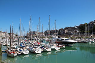
Saint-Valery-en-Caux is a commune in the Seine-Maritime department in the Normandy region in northern France.

Saint-Nicolas-de-la-Taille Commune in Normandy, France

Saint-Nicolas-de-la-Taille is a commune in the Seine-Maritime department in the Normandy region in northern France.

Saint-Pierre-Bénouville is a commune in the Seine-Maritime department in the Normandy region in north-western France.

Saint-Pierre-des-Jonquières Commune in Normandy, France

Saint-Pierre-des-Jonquières is a commune in the Seine-Maritime department in the Normandy region in northern France.

Saint-Sauveur-d'Émalleville is a commune in the Seine-Maritime department in the Normandy region in northern France.

<span class="mw-page-title-main">Saint-Vaast-d'Équiqueville</span> Commune in Normandy, France

Saint-Vaast-d'Équiqueville is a commune in the Seine-Maritime department in the Normandy region in north-western France.

<span class="mw-page-title-main">Saint-Victor-l'Abbaye</span> Commune in Normandy, France

Saint-Victor-l'Abbaye is a commune in the Seine-Maritime department in the Normandy region in north-western France.

Saint-Germain-des-Essourts Commune in Normandy, France

Saint-Germain-des-Essourts is a commune in the Seine-Maritime department in the Normandy region in northern France.

Saint-Denis-d'Aclon is a commune in the Seine-Maritime department in the Normandy region in north-western France.

Dampierre-Saint-Nicolas Commune in Normandy, France

Dampierre-Saint-Nicolas is a commune in the Seine-Maritime department in the Normandy region in northern France.

<span class="mw-page-title-main">Hautot-sur-Seine</span> Commune in Normandy, France

Hautot-sur-Seine is a commune in the Seine-Maritime department in the Normandy region in north-western France.

<span class="mw-page-title-main">Heurteauville</span> Commune in Normandy, France

Heurteauville is a commune in the Seine-Maritime department in the Normandy region in north-western France.

Saint-Crespin Commune in Normandy, France

Saint-Crespin is a commune in the Seine-Maritime department in the Normandy region in north-western France.

<span class="mw-page-title-main">Saint-Martin-du-Manoir</span> Commune in Normandy, France

Saint-Martin-du-Manoir is a commune in the Seine-Maritime department in the Normandy region in northern France.

<span class="mw-page-title-main">Veulettes-sur-Mer</span> Commune in Normandy, France

Veulettes-sur-Mer is a commune in the Seine-Maritime department in the Normandy region in northern France.

Saint-Léger-aux-Bois, Seine-Maritime Commune in Normandy, France

Saint-Léger-aux-Bois is a commune in the Seine-Maritime department in the Normandy region in northern France.

Saint-Pierre-le-Vieux, Seine-Maritime Commune in Normandy, France

Saint-Pierre-le-Vieux is a commune in the Seine-Maritime department in the Normandy region in north-western France.

The Canton of Londinières is a former canton situated in the Seine-Maritime département and in the Haute-Normandie region of northern France. It was disbanded following the French canton reorganisation which came into effect in March 2015. It consisted of 16 communes, which joined the canton of Neufchâtel-en-Bray in 2015. It had a total of 5,251 inhabitants (2012).

The Communauté de communes de Londinières is located in the Seine-Maritime département of the Normandy region of north-western France. It was created on 11 December 2000 and its seat is Londinières. Its area is 194.6 km2, and its population was 5,255 in 2018.

References

  1. "Répertoire national des élus: les maires". data.gouv.fr, Plateforme ouverte des données publiques françaises (in French). 9 August 2021.
  2. "Populations légales 2019". The National Institute of Statistics and Economic Studies. 29 December 2021.
  3. 1 2 Des villages de Cassini aux communes d'aujourd'hui: Commune data sheet Osmoy-Saint-Valery, EHESS. (in French)
  4. Population en historique depuis 1968, INSEE