Guttenberg, Iowa

Last updated

City of Guttenberg
GuttenbergatChristmas.JPG
A view of Guttenberg from Acre Street December 2007
Motto(s): 
A Great Place to Do Business, Live, Work and Play!
Clayton County Iowa Incorporated and Unincorporated areas Guttenberg Highlighted.svg
Location of Guttenberg in Iowa
Coordinates: 42°47′10″N91°6′5″W / 42.78611°N 91.10139°W / 42.78611; -91.10139
Country United States
State Flag of Iowa.svg  Iowa
County Clayton
Incorporated1851
Government
  MayorFred Schaub
  City CouncilJane Parker, Austin Greve, Steve Bahls, Michelle Geuder and Mandy Ludovissy
Area
[1]
  Total2.23 sq mi (5.77 km2)
  Land2.19 sq mi (5.68 km2)
  Water0.04 sq mi (0.09 km2)
Elevation
625 ft (188 m)
Population
 (2020)
  Total1,817
  Density828.17/sq mi (319.72/km2)
Time zone UTC-6 (Central Standard Time)
  Summer (DST) UTC-5 (Central Daylight Time)
Zip Code
52052
Area code 563
FIPS code 19-33465
GNIS feature ID0457187
Website www.cityofguttenberg.com

Guttenberg is a city in Clayton County, Iowa, United States, along the Mississippi River. The population was 1,817 at the time of the 2020 census, down from 1,987 at the 2000 census. [2]

Contents

History

Prairie La Porte, meaning "the door to the prairie," was the first name given to Guttenberg by French explorers in 1673. [3] The Guttenberg area was a site of Sac and Fox campgrounds until 1823. The Louisiana Purchase of 1803 transferred ownership to the United States and the Black Hawk Purchase of 1833 finally opened the area for legal settlement.

Guttenberg's past is preserved today in the many limestone buildings built by German immigrants in the mid-to-late 19th century. These structures were used for both residential and commercial purposes. Many such as the Albertus Building are pre–Civil War era and are preserved in the Front Street Historic District.

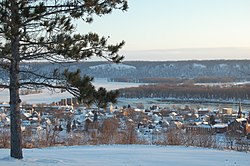
Guttenberg's riverfront location was pivotal in its early commercial development. The town first served as a focal point for westward settlement and as an early governmental and administrative center. It was the early location of the county seat from 1838 to 1843. Guttenberg served as a supply center for the general area until the Civil War, when railroads and an interior road system combined to detract from Guttenberg's role as a market center.

The earliest businesses included general supply stores, blacksmith, wagon shops, and hotels. The loss of the county seat in 1843 slowed growth and the population declined. Economic revival began in 1845 with the influx of hundreds of German immigrants under the auspices of the Western Settlement Society of Cincinnati and continued with the development of the lead mining industry along Miners Creek.

The German immigration began in 1845, and by 1850 the town was sizable and nearly all German. The city takes its name from Johannes Gutenberg, the inventor of movable type. Many of the town's streets are named for 18th & 19th century German writers, poets, playwrights and philosophers such as Koerner, Herman, Weiland, Lessing, Schiller, Herder and Goethe, whose writings became prolific in Germany because of Johannes Gutenberg's invention. A replica of a Bible Gutenberg printed is on display at the public library.

Guttenberg incorporated in 1851. The influence of the German population was best indicated by the construction during the period between 1845 and 1865 for over one hundred stone buildings. The bluff limestone was easily obtained and good, local clay and lime for construction was available. Four large riverside warehouses opened and a large flour mill, stores, and hotels appeared during this period. The steamboat trade deposited merchandise and picked up farm produce, milled flour and lead ore.

Guttenberg experienced many floods, the most recent and devastating being in 1965, after which a levee was built. Today, Guttenberg's population is 1,817 and it is the largest town in Clayton County.

Geography

Guttenberg is located at 42°47′10″N91°6′5″W / 42.78611°N 91.10139°W / 42.78611; -91.10139 (42.785992, -91.101366). [4]
According to the United States Census Bureau, the city has a total area of 2.12 square miles (5.49 km2), of which, 2.09 square miles (5.41 km2) is land and 0.03 square miles (0.08 km2) is water. [5]

The community is next to the Mississippi River across from Wisconsin and is on US Route 52.

Climate

Guttenberg has a humid continental climate (Köppen climate classification Dfa).

Climate data for Guttenberg
MonthJanFebMarAprMayJunJulAugSepOctNovDecYear
Record high °F (°C)60
(16)
64
(18)
87
(31)
97
(36)
95
(35)
101
(38)
102
(39)
103
(39)
98
(37)
94
(34)
78
(26)
68
(20)
103
(39)
Mean daily maximum °F (°C)27
(−3)
33
(1)
45
(7)
59
(15)
72
(22)
81
(27)
85
(29)
83
(28)
75
(24)
62
(17)
45
(7)
31
(−1)
58
(14)
Mean daily minimum °F (°C)8
(−13)
15
(−9)
26
(−3)
39
(4)
50
(10)
60
(16)
64
(18)
62
(17)
53
(12)
42
(6)
28
(−2)
16
(−9)
39
(4)
Record low °F (°C)−36
(−38)
−38
(−39)
−30
(−34)
7
(−14)
27
(−3)
40
(4)
46
(8)
40
(4)
27
(−3)
14
(−10)
−11
(−24)
−29
(−34)
−38
(−39)
Average precipitation inches (mm)1.09
(28)
1.14
(29)
2.01
(51)
3.25
(83)
3.80
(97)
4.42
(112)
4.12
(105)
4.36
(111)
3.01
(76)
2.17
(55)
2.23
(57)
1.32
(34)
32.92
(836)
Source: The Weather Channel [6]

Demographics

Historical populations
YearPop.±%
1860 1,104    
1870 1,040−5.8%
1880 1,076+3.5%
1890 1,160+7.8%
1900 1,620+39.7%
1910 1,873+15.6%
1920 1,666−11.1%
1930 1,918+15.1%
1940 1,860−3.0%
1950 1,912+2.8%
1960 2,087+9.2%
1970 2,177+4.3%
1980 2,428+11.5%
1990 2,257−7.0%
2000 1,987−12.0%
2010 1,914−3.7%
2020 1,817−5.1%
Source: "American FactFinder". United States Census Bureau. Archived from the original on April 11, 2012. Retrieved March 29, 2020. and Iowa Data Center
Source:
U.S. Decennial Census [7] [2]
The population of Guttenberg, Iowa from US census data GuttenbergIowaPopPlot.png
The population of Guttenberg, Iowa from US census data

2020 census

As of the census of 2020, [8] the population was 1,817. The population density was 828.2 inhabitants per square mile (319.8/km2). There were 1,047 housing units at an average density of 477.2 per square mile (184.2/km2). The racial makeup of the city was 96.0% White, 0.4% Black or African American, 0.4% Native American, 0.2% Asian, 0.1% Pacific Islander, 0.8% from other races, and 2.1% from two or more races. Ethnically, the population was 0.8% Hispanic or Latino of any race.

2010 census

As of the census [9] of 2010, there were 1,919 people, 887 households, and 516 families residing in the city. The population density was 918.2 inhabitants per square mile (354.5/km2). There were 1,085 housing units at an average density of 519.1 per square mile (200.4/km2). The racial makeup of the city was 98.3% White, 0.2% African American, 0.5% Asian, 0.1% Pacific Islander, 0.4% from other races, and 0.5% from two or more races. Hispanic or Latino of any race were 1.3% of the population.

There were 887 households, of which 20.2% had children under the age of 18 living with them, 47.8% were married couples living together, 7.0% had a female householder with no husband present, 3.4% had a male householder with no wife present, and 41.8% were non-families. 37.4% of all households were made up of individuals, and 21.1% had someone living alone who was 65 years of age or older. The average household size was 2.06 and the average family size was 2.66.

The median age in the city was 51.3 years. 17.2% of residents were under the age of 18; 5.7% were between the ages of 18 and 24; 16.9% were from 25 to 44; 32.4% were from 45 to 64; and 27.8% were 65 years of age or older. The gender makeup of the city was 47.1% male and 52.9% female.

2000 census

As of the census [10] of 2000, there were 1,987 people, 837 households, and 534 families residing in the city. The population density was 962.3 inhabitants per square mile (371.5/km2). There were 935 housing units at an average density of 452.8 per square mile (174.8/km2). The racial makeup of the city was 98.89% White, 0.45% African American, 0.05% Native American, 0.15% Asian, 0.05% from other races, and 0.40% from two or more races. Hispanic or Latino of any race were 0.50% of the population.

There were 837 households, out of which 26.3% had children under the age of 18 living with them, 52.7% were married couples living together, 7.5% had a female householder with no husband present, and 36.2% were non-families. 32.7% of all households were made up of individuals, and 18.0% had someone living alone who was 65 years of age or older. The average household size was 2.21 and the average family size was 2.77.

In the city, the population was spread out, with 21.0% under the age of 18, 6.0% from 18 to 24, 22.6% from 25 to 44, 24.2% from 45 to 64, and 26.2% who were 65 years of age or older. The median age was 45 years. For every 100 females, there were 88.3 males. For every 100 females age 18 and over, there were 85.6 males.

The median income for a household in the city was $29,151, and the median income for a family was $33,393. Males had a median income of $25,265 versus $16,897 for females. The per capita income for the city was $17,098. About 4.0% of families and 8.4% of the population were below the poverty line, including 12.5% of those under age 18 and 7.0% of those age 65 or over.

Education

Public schools are operated by the Clayton Ridge Community School District, [11] which formed in 2005 in the merger of the Guttenberg Community School District and the Garnavillo Community School District. [12]

St. Mary IC School, a Catholic K-8, is in operation. [13] It formerly had a senior high school division that closed in 1968. [14]

Notable people

See also

Lock and Dam number 10 Mississippi River Lock and Dam number 10.jpg
Lock and Dam number 10

Related Research Articles

<span class="mw-page-title-main">Clayton County, Iowa</span> County in Iowa, United States

Clayton County is a county located in the U.S. state of Iowa. As of the 2020 census, the population was 17,043. Its county seat is Elkader. The county was established in 1837 and was named in honor of John M. Clayton, United States Senator from Delaware and later Secretary of State under President Zachary Taylor.

<span class="mw-page-title-main">Sumner, Iowa</span> City in Iowa, United States

Sumner is a city in Bremer County, Iowa, United States. The city is located along the county's eastern border, between Bremer and Fayette counties. The population was 2,021 at the time of the 2020 census. The Bremer County portion of Sumner is part of the Waterloo–Cedar Falls Metropolitan Statistical Area.

<span class="mw-page-title-main">Fairbank, Iowa</span> City in Iowa, United States

Fairbank is a city in Buchanan and Fayette counties in the U.S. state of Iowa. The population was 1,111 at the time of the 2020 census.

<span class="mw-page-title-main">Greene, Iowa</span> City in Iowa, United States

Greene is a city in Butler County, Iowa, United States, along the Shell Rock River, and along Butler County's northern border, where Butler and Floyd counties meet. The population was 990 at the time of the 2020 census.

<span class="mw-page-title-main">Clayton, Iowa</span> City in Iowa, United States

Clayton is a city in Clayton County, Iowa, United States. The population was 45 at the 2020 census, down from 55 in 2000. Clayton is located directly on the Mississippi River and is only accessible via a very steep road.

<span class="mw-page-title-main">Edgewood, Iowa</span> City in Iowa, United States

Edgewood is a city in Clayton and Delaware counties in the U.S. state of Iowa. Highway 3, which runs through the center of town, is the dividing line between the two counties. The Edgewood post office was established in 1852 on the Clayton side of the town. Edgewood was formally incorporated in 1892, although it had a functioning council for some time before that date. The population was 909 at the time of the 2020 census, down from 923 in 2000.

<span class="mw-page-title-main">Elkader, Iowa</span> City in Iowa, United States

Elkader is a city in Clayton County, Iowa, United States. The population was 1,209 at the time of the 2020 census, down from 1,465 in 2000. It is the county seat of Clayton County. It is the site of Iowa's lowest recorded minimum temperature, −44 °C (−47 °F) on February 3, 1996.

<span class="mw-page-title-main">Farmersburg, Iowa</span> City in Iowa, United States

Farmersburg is a city in Clayton County, Iowa, United States. The population was 271 at the time of the 2020 census, down from 300 in 2000. The current Mayor is Glenn Radloff, a cross-country truck driver.

<span class="mw-page-title-main">Garnavillo, Iowa</span> City in Iowa, United States

Garnavillo is a city in Clayton County, Iowa, United States. The population was 763 at the time of the 2020 census, up from 754 in 2000.

<span class="mw-page-title-main">Luana, Iowa</span> City in Iowa, United States

Luana is a city in Clayton County, Iowa, United States. The population was 301 at the time of the 2020 census, up from 249 in 2000.

<span class="mw-page-title-main">Millville, Iowa</span> Unincorporated in Iowa, United States

Millville is an unincorporated town and former city in Clayton County, Iowa, United States. The population was 30 at the 2010 census, up from 23 in the 2000 census, before it became unincorporated.

<span class="mw-page-title-main">Monona, Iowa</span> City in Iowa, United States

Monona is a city in Clayton County, Iowa, United States. The population was 1,471 at the time of the 2020 census.

<span class="mw-page-title-main">North Buena Vista, Iowa</span> City in Iowa, United States

North Buena Vista is a city in Clayton County, Iowa, United States. The population was 109 at the time of the 2020 census, down from 124 in 2000.

<span class="mw-page-title-main">Osterdock, Iowa</span> City in Iowa, United States

Osterdock is a city located in Clayton County, Iowa, United States. As of the 2020 census, the city had a total population of 43, down from 50 in 2000.

<span class="mw-page-title-main">Strawberry Point, Iowa</span> City in Iowa, United States

Strawberry Point is a city in Clayton County, Iowa, United States. The population was 1,155 at the time of the 2020 United States Census, down from 1,386 in 2000 census. Strawberry Point is home to the world's largest strawberry, and the Franklin Hotel, which was listed on the National Register of Historic Places in 1999. Backbone State Park, Iowa's oldest state park, is located a few miles from the town.

<span class="mw-page-title-main">Volga, Iowa</span> City in Iowa, United States

Volga is a city in Clayton County, Iowa, United States. The population was 203 at the time of the 2020 census, down from 247 in 2000.

<span class="mw-page-title-main">Woodbine, Iowa</span> City in Iowa, United States

Woodbine is a city in Harrison County, Iowa, United States, along the Boyer River. The population was 1,625 at the time of the 2020 census.

<span class="mw-page-title-main">Walker, Iowa</span> City in Iowa, United States

Walker is a city in Linn County, Iowa. The population was 688 at the 2020 census. It is part of the Cedar Rapids, Iowa metropolitan area.

<span class="mw-page-title-main">Wapello, Iowa</span> City in Iowa, United States

Wapello is a city in and the county seat of Louisa County, Iowa, United States. The population was 2,084 at the time of the 2020 census.

<span class="mw-page-title-main">Clayton, Ohio</span> City in Ohio, United States

Clayton is a city in Montgomery County, Ohio, United States. The population was 13,310 at the 2020 census. A suburb of Dayton, it is part of the Dayton metropolitan area.

References

  1. "2020 U.S. Gazetteer Files". United States Census Bureau. Retrieved March 16, 2022.
  2. 1 2 "2020 Census State Redistricting Data". census.gov. United states Census Bureau. Retrieved August 12, 2021.
  3. Klinkenberg, Dean (October 1, 2009). Travel Guide-Lansing Iowa to Leclaire: Along the Mississippi River in Iowa, Illinois and Wisconsin: Lansing Iowa to Leclaire. Dean Klinkenberg. p. 64. ISBN   9780971690448 . Retrieved May 4, 2013.
  4. "US Gazetteer files: 2010, 2000, and 1990". United States Census Bureau. February 12, 2011. Retrieved April 23, 2011.
  5. "US Gazetteer files 2010". United States Census Bureau . Retrieved May 11, 2012.
  6. "Average weather for Guttenberg". The Weather Channel . Retrieved March 19, 2011.
  7. "Census of Population and Housing". Census.gov. Retrieved June 4, 2015.
  8. "2020 Decennial Census: Guttenberg city, Iowa". data.census.gov. U.S. Census Bureau. Retrieved July 22, 2022.
  9. "American FactFinder". United States Census Bureau . Retrieved May 11, 2012.
  10. "American FactFinder". United States Census Bureau . Retrieved January 31, 2008.
  11. "Clayton Ridge." Iowa Department of Education. Retrieved on February 23, 2019.
  12. "REORGANIZATION & DISSOLUTION ACTIONS SINCE 1965-66 Archived 2019-02-09 at the Wayback Machine ." Iowa Department of Education. Retrieved on February 23, 2019.
  13. Home. St. Mary IC School. Retrieved on February 24, 2019.
  14. "History." St. Mary IC School. Retrieved on February 26, 2019.
  15. "SCHAEFER, Daniel". Biographical Directory of the United States Congress. Retrieved March 19, 2011.
  16. "Lee Kunzman Racing career". DRIVER DATABASE. Retrieved March 19, 2011.