The Line Wall Curtain is a defensive curtain wall that forms part of the fortifications of the British Overseas Territory of Gibraltar.

The North Bastion, formerly the Baluarte San Pablo was part of the fortifications of Gibraltar, in the north of the peninsula, protecting the town against attack from the mainland of Spain. The bastion was based on the older Giralda tower, built in 1309. The bastion, with a mole that extended into the Bay of Gibraltar to the west and a curtain wall stretching to the Rock of Gibraltar on its east, was a key element in the defenses of the peninsula. After the British took Gibraltar in 1704 they further strengthened these fortifications, flooding the land in front and turning the curtain wall into the Grand Battery.

The Twelfth Siege of Gibraltar was fought between September 1704 and May 1705 during the War of the Spanish Succession. It followed the capture in August 1704 of the fortified town of Gibraltar, at the southern tip of Spain, by an Anglo–Dutch naval force led by Sir George Rooke and Prince George of Hesse-Darmstadt. The members of the Grand Alliance, Holy Roman Empire, England, the Netherlands, Pro-Habsburg Spain, Portugal and the Savoy, had allied to prevent the unification of the French and Spanish thrones by supporting the claim of the Habsburg pretender Archduke Charles VI of Austria as Charles III of Spain. They were opposed by the rival claimant, the Bourbon Philip, Duke of Anjou, ruling as Philip V of Spain, and his patron and ally, Louis XIV of France. The war began in northern Europe and was largely contained there until 1703, when Portugal joined the confederate powers. From then, English naval attentions were focused on mounting a campaign in the Mediterranean to distract the French navy and disrupt French and Bourbon Spanish shipping or capture a port for use as a naval base. The capture of Gibraltar was the outcome of that initial stage of the Mediterranean campaign.

King's Bastion is a coastal bastion on the western front of the fortifications of the British overseas territory of Gibraltar, protruding from the Line Wall Curtain. It is located between Line Wall Road and Queensway and overlooks the Bay of Gibraltar. It played a crucial role in defending The Rock during the Great Siege of Gibraltar. In more recent history the bastion was converted into a generating station which powered Gibraltar's electricity needs. Today it continues to serve the community as Gibraltar's leisure centre.

Wellington Front is a fortification in the British Overseas Territory of Gibraltar. It was built in 1840 on a site established by the Spanish in 1618.

Jumper's Bastion may refer to one of two adjacent bastions in the British Overseas Territory of Gibraltar. They were both created in 1785 on the sites of previous constructions and named for a British Captain who was one on the first on shore during the Capture of Gibraltar in 1704.
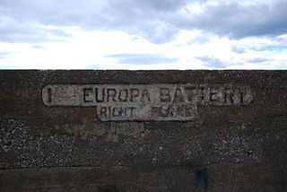
The Europa Batteries are a group of artillery batteries in the British Overseas Territory of Gibraltar. Facing the North African coast, they are the most southerly batteries in Gibraltar and were built to cover ships approaching from the Mediterranean Sea. They run along the fortified clifftops of Europa Point from Camp Bay on the west side of the Rock of Gibraltar to the Europa Advance Batteries on the east side.
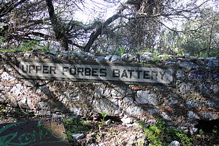
Forbes' Batteries are a pair of artillery batteries in the British Overseas Territory of Gibraltar. The batteries are casemated.

Grand Battery is an artillery battery in the British Overseas Territory of Gibraltar. To the west of the grand battery was a very formidable flank which was considered to have been a "great annoyance to the besiegers."

Zoca Flank Battery is an artillery battery on the west side of the British Overseas Territory of Gibraltar.
Woodford's Battery was an artillery battery in the British Overseas Territory of Gibraltar. It is located at Europa Flats between the Defensible Barracks and the Officer's Barracks and Eliott's Battery.

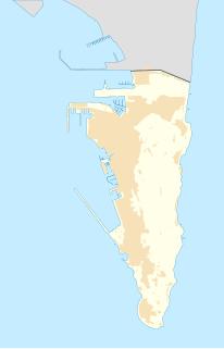
The fortifications of Gibraltar have made the Rock of Gibraltar and its environs "probably the most fought over and most densely fortified place in Europe, and probably, therefore, in the world", as Field Marshal Sir John Chapple has put it. The Gibraltar peninsula, located at the far southern end of Iberia, has great strategic importance as a result of its position by the Strait of Gibraltar where the Mediterranean Sea meets the Atlantic Ocean. It has repeatedly been contested between European and North African powers and has endured fourteen sieges since it was first settled in the 11th century. The peninsula's occupants – Moors, Spanish, and British – have built successive layers of fortifications and defences including walls, bastions, casemates, gun batteries, magazines, tunnels and galleries. At their peak in 1865, the fortifications housed around 681 guns mounted in 110 batteries and positions, guarding all land and sea approaches to Gibraltar. The fortifications continued to be in military use until as late as the 1970s and by the time tunnelling ceased in the late 1960s, over 34 miles (55 km) of galleries had been dug in an area of only 2.6 square miles (6.7 km2).

The Lines of Contravallation of Gibraltar, known in English as the "Spanish Lines", were a set of fortifications built by the Spanish across the northern part of the isthmus linking Spain with Gibraltar. They later gave their name to the Spanish town of La Línea de la Concepción. The Lines were constructed after 1730 to establish a defensive barrier across the peninsula, with the aim of preventing any British incursions, and to serve as a base for fresh Spanish attempts to retake Gibraltar. They played an important role in the Great Siege of Gibraltar between 1779 and 1783 when they supported the unsuccessful French and Spanish assault on the British-held fortress. The siege was ended after the lines of contravallation were attacked by British and Dutch forces under the command of the Governor of Gibraltar,General Augustus Eliot. The attack caused the Spanish forces to retreat and abandon the fortifications and the combined British led forces virtually destroyed all the Spanish gun batteries and the enemy cannon and munitions either captured or destroyed. This attack is still commemorated to this day and is known as 'Sortie Day'.

The King's Lines are a walled rock-cut trench on the lower slopes of the north-west face of the Rock of Gibraltar. Forming part of the Northern Defences of the fortifications of Gibraltar, they were originally created some time during the periods when Gibraltar was under the control of the Moors or Spanish. They are depicted in a 1627 map by Don Luis Bravo de Acuña, which shows their parapet following a tenaille trace. The lines seem to have been altered subsequently, as maps from the start of the 18th century show a more erratic course leading from the Landport, Gibraltar's main land entrance, to the Round Tower, a fortification at their western end. A 1704 map by Johannes Kip calls the Lines the "Communication Line of the Round Tower".

The Prince of Wales Lines were a set of earthworks constructed in Gibraltar in 1756 on the orders of Lord Tyrawley, during his term as Governor of Gibraltar. They consisted of a series of retrenchments for guns and muskets constructed between the glacis of the South Front to the New Mole, south of Gibraltar's urban area.
The Queen's Lines are a set of fortified lines, part of the fortifications of Gibraltar, situated on the lower slopes of the north-west face of the Rock of Gibraltar. They occupy a natural ledge which overlooks the landward entrance to Gibraltar and were an extension to the north-east of the King's Lines. They run from a natural fault called the Orillon to a cliff above the modern Laguna Estate, which stands on the site of the Inundation, an artificial lake created to obstruct landward access to Gibraltar. The Prince's Lines run immediately behind and above them on a higher ledge. All three of the Lines were constructed to enfilade attackers approaching Gibraltar's Landport Front from the landward direction.
Prince Albert's Front is a curtain wall that formerly comprised part of the seafront fortifications of Gibraltar. It runs between the King's Bastion and Orange Bastion. The Front was constructed in 1842 after a report by Major General Sir John Thomas Jones recommended improving Gibraltar's seafront defences to guard against the threat of an amphibious assault. It was named after Prince Albert, Queen Victoria's prince consort. The Front straightened out the line of Gibraltar's coastal curtain wall; parts of the original curtain wall, some of which dates from the Moorish period over 500 years ago, can still be seen.
The Prince's Lines are part of the fortifications of Gibraltar, situated on the lower slopes of the north-west face of the Rock of Gibraltar. They are located at a height of about 70 feet (21 m) on a natural ledge above the Queen's Lines, overlooking the landward entrance to Gibraltar, and run from a natural fault called the Orillon to a cliff at the southern end of the isthmus linking Gibraltar with Spain. The lines face out across the modern Laguna Estate, which stands on the site of the Inundation, an artificial lake created to obstruct landward access to Gibraltar. They were constructed to enfilade attackers approaching Gibraltar's Landport Front from the landward direction.
The Retrenched Barracks was a fortified barracks located at Windmill Hill in the British Overseas Territory of Gibraltar. It stands to the north of the southern tip of Gibraltar, Europa Point, which was long felt to be potentially vulnerable to a surprise attack from the sea and was heavily fortified with gun batteries, perimeter walls and scarped cliffs.
