Historic counties of the United Kingdom

Last updated
Historic county
  • Also known as:
  • Ancient or geographic county [1]
  • Traditional county [2]
Historic counties of the United Kingdom.svg
Location United Kingdom
Number92
Possible types

The Historic counties of the United Kingdom are ancient geographical divisions of the United Kingdom. Although not defined by any one function, over many centuries, various forms of administrative function have been based on them. [3] These have included the areas of Parliamentary constituencies, the Court of quarter sessions, the areas in which a Lord-lieutenant and Sheriff serve, territorial units of the Militia, as well as the basis of the original county councils. Although these areas have subsequently changed, the historic counties on which they were originally based have not. [4] The Office for National Statistics recommended them in the Index of Place Names as a stable, unchanging geography which covers the whole of Great Britain. [2]

Contents

History

England

The division of England into shires, later known as counties, began in the Kingdom of Wessex in the mid-Saxon period, many of the Wessex shires representing previously independent kingdoms. With the Wessex conquest of Mercia in the 9th and 10th centuries, the system was extended to central England. At the time of the Domesday Book, northern England comprised Cheshire and Yorkshire (with the north-east being unrecorded). The remaining counties of the north (Westmorland, Lancashire, Cumberland, Northumberland and Durham) were established in the 12th century. [3] Rutland was first recorded as a county in 1159. [5]

Scotland

The Scottish counties have their origins in the 'sheriffdoms' first created in the reign of Alexander I (1107–24) and extended by David I (1124–53). The sheriff, operating from a royal castle, was the strong hand of the king in his sheriffdom with all embracing duties – judicial, military, financial and administrative. Sheriffdoms had been established over most of southern and eastern Scotland by the mid-13th century. Although there was a degree of fluidity in the areas of these early sheriffdoms, the pattern that existed in the late mediæval period is believed to be very close to that existing in the mid-nineteenth century. The central and western Highlands and the Isles (where resistance to Government was strongest) were not assigned to shires until the early modern period, Caithness becoming a sheriffdom in 1503 and Orkney in 1540. [3]

Wales

The present-day pattern of the historic counties of Wales was established by the Laws in Wales Act 1535. This Act abolished the powers of the lordships of the March and established the Counties or shires of Denbigh, Montgomery, Radnor, Brecknock and Monmouth from the areas of the former lordships. The other eight counties had, by then, already been in existence since at least the 13th century. [3] The historic counties are, however, based on much older traditional areas. [6]

Northern Ireland

The division of Ireland into counties began during the reign of King John (1199-1216). This process continued for several hundred years, as more of Ireland came under the control of the English crown. Munster was divided into counties in 1571 and Connaught in 1579. Finally, Ulster was shired during the reign of James I. The complete set of counties as they are today were laid down in 1584 (with their modern boundaries not finally settled until 1605, or 1613 in the case of Londonderry albeit that it had existed as County Coleraine from Anglo-Norman times). [3] As in Wales the counties were generally based on earlier, traditional areas. [7]

Map

Historic counties of the United Kingdom (detached parts not shown separately) Historic counties of the United Kingdom.svg
Historic counties of the United Kingdom (detached parts not shown separately)

Related Research Articles

A shire is a traditional term for a division of land, found in Great Britain, Australia, New Zealand and some other English-speaking countries. It was first used in Wessex from the beginning of Anglo-Saxon settlement, and spread to most of the rest of England in the tenth century. In some rural parts of Australia, a shire is a local government area; however, in Australia it is not synonymous with a "county", which is a lands administrative division.
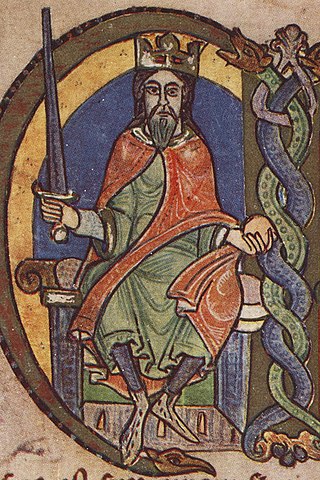
County Geographical and administrative region in some countries

A county is a geographical region of a country used for administrative or other purposes in certain modern nations. The term is derived from the Old French conté or cunté denoting a jurisdiction under the sovereignty of a count (earl) or a viscount. Literal equivalents in other languages, derived from the equivalent of "count", are now seldom used officially, including comté, contea, contado, comtat, condado, Grafschaft, graafschap, and zhupa in Slavic languages; terms equivalent to English language administrative terms such as municipality, district, circuit and commune/community are now often instead used.

Earl is a rank of the nobility in Britain. The title originates in the Old English word eorl, meaning "a man of noble birth or rank". The word is cognate with the Scandinavian form jarl, and meant "chieftain", particularly a chieftain set to rule a territory in a king's stead. In Scandinavia, it became obsolete in the Middle Ages and was replaced by duke (hertig/hertug/hertog). After the Norman Conquest, it became the equivalent of the continental count. However, earlier in Scandinavia, jarl could also mean a sovereign prince. For example, the rulers of several of the petty kingdoms of Norway had the title of jarl and in many cases they had no less power than their neighbours who had the title of king. Alternative names for the rank equivalent to "earl" or "count" in the nobility structure are used in other countries, such as the hakushaku (伯爵) of the post-restoration Japanese Imperial era.

Historic counties of England Geographical designations for areas of England, based on historical traditions

The historic counties of England are areas that were established for administration by the Normans, in many cases based on earlier kingdoms and shires created by the Anglo-Saxons and others. They are alternatively known as ancient counties, traditional counties, former counties or simply as counties. In the centuries that followed their establishment, as well as their administrative function, the counties also helped define local culture and identity. This role continued even after the counties ceased to be used for administration after the creation of administrative counties in 1889, which were themselves amended by further local government reforms in the years following.

Historic counties of Wales Sub-divisions in Wales

The historic counties of Wales are sub-divisions of Wales. They were used for various functions for several hundred years, but for administrative purposes have been superseded by contemporary sub-national divisions, some of which bear some limited similarity to the historic entities in name and extent. They are alternatively known as ancient counties.

Shires of Scotland Historic administrative and geographical division of Scotland

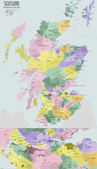
The shires of Scotland, or counties of Scotland, are historic subdivisions of Scotland established in the Middle Ages and used as administrative divisions until 1975. Originally established for judicial purposes, from the 17th century they started to be used for local administration purposes as well. The areas used for judicial functions (sheriffdoms) came to diverge from the shires, which ceased to be used for local government purposes after 1975 under the Local Government (Scotland) Act 1973.

Subdivisions of Scotland Present or former administrative subdivisions of Scotland

For local government purposes, Scotland is divided into 32 areas designated as "council areas", which are all governed by single-tier authorities designated as "councils". They have the option under the Local Government (Scotland) Act 1997 of being known as a "comhairle" when opting for a Gaelic name; only Comhairle nan Eilean Siar has chosen this option, whereas the Highland Council has adopted its Gaelic form alongside its English equivalent informally.

In Middle Ages in England and Scotland the Chief Justiciar was roughly equivalent to a modern Prime Minister of the United Kingdom as the monarch's chief minister. Similar positions existed in continental Europe, particularly in Norman Italy and in the Carolingian Empire. The term is the English form of the medieval Latin justiciarius or justitiarius.

Strathearn

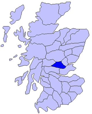
Strathearn or Strath Earn is the strath of the River Earn, in Scotland, extending from Loch Earn in the West to the River Tay in the east. The region formed a traditional province of Scotland, and hence had a mormaer and then an Earl. The province was bounded on the north by Atholl, north west by Breadalbane, south west by Menteith, south east by Fife, and on the east by Perthia.

Kingdom of England Historic sovereign kingdom on the British Isles (927–1649; 1660–1707)

The Kingdom of England was a sovereign state on the island of Great Britain from 12 July 927, when it emerged from various Anglo-Saxon kingdoms, until 1 May 1707, when it united with Scotland to form the Kingdom of Great Britain. The Kingdom of England was among the most powerful states in Europe during the medieval period.

Marr

Marr is one of six committee areas in Aberdeenshire, Scotland. It has a population of 34,038. Someone from Marr is called a Màrnach in Scottish Gaelic.

Sheriffdom

A sheriffdom is a judicial district in Scotland, led by a sheriff principal. Since 1 January 1975, there have been six sheriffdoms. Each sheriffdom is divided into a series of sheriff court districts, and each sheriff court is presided over by a resident or floating sheriff. Sheriffs principal and resident or floating sheriffs are all members of the judiciary of Scotland.

History of local government in Scotland

The History of local government in Scotland is a complex tale of largely ancient and long established Scottish political units being replaced after the mid 20th century by a frequently changing series of different local government arrangements.

Scotland in the High Middle Ages Scotland between about 900 and 1286 CE

The High Middle Ages of Scotland encompass Scotland in the era between the death of Domnall II in 900 AD and the death of King Alexander III in 1286, which was an indirect cause of the Wars of Scottish Independence.

History of local government in England Aspect of history

The history of local government in England is one of gradual change and evolution since the Middle Ages. England has never possessed a formal written constitution, with the result that modern administration is based on precedent, and is derived from administrative powers granted to older systems, such as that of the shires.

Strathgryffe

Strathgryffe or Gryffe Valley (Gaelic: Srath Ghriobhaidh is a strath centred on the River Gryffe in the west central Lowlands of Scotland. The River Gryffe passes through the council areas of Inverclyde and Renfrewshire, rising in Kilmacolm and joining the Black Cart Water between Houston and Inchinnan.

England–Wales border National boundary between England and Wales

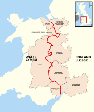
The England–Wales border, sometimes referred to as the Wales–England border or the Anglo–Welsh border, runs for 160 miles (260 km) from the Dee estuary, in the north, to the Severn estuary in the south, separating England and Wales.

A sheriffdom is a judicial district of Scotland. Originally identical to the Shires of Scotland, from the eighteenth century many counties were grouped to form "sheriffdoms".

Counties of Meath and Westmeath Act 1543 Irish Act dividing County Meath into Meath and Westmeath

An Act for the division of Meath into two shires was an Act of the Parliament of Ireland passed in 1542 which resulted in the division of County Meath, shired in 1297, into the counties of Meath and Westmeath. The Act commenced on Saint Catherine's Day in 1542 and remains in effect.

References

  1. Census of England and Wales 1891, General Register Office, HMSO
  2. 1 2 Index of Place Names in Great Britain (IPN) 2019 User Guide v 1.1, Office for National Statistics
  3. 1 2 3 4 5 "Historic Counties Standard" (PDF). Historic Counties Trust. 2015.
  4. "Celebrating the historic counties of England". Ministry of Housing, Communities & Local Government. 16 July 2019.
  5. Victoria County History of Rutland.
  6. Rees, W., 1972, An Historical Atlas of Wales, Faber and Faber
  7. Edwards, R.D., 1973, An Atlas of Irish History, Methuen

See also