Kellas, Angus

Last updated

Kellas
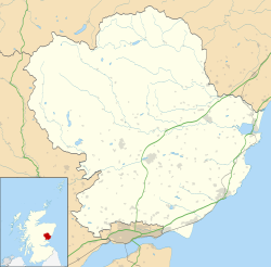
Angus UK location map.svg
Red pog.svg
Location within Angus
OS grid reference NO456354
Council area
Lieutenancy area
Country Scotland
Sovereign state United Kingdom
Post town DUNDEE
Postcode district DD5
Dialling code 01382
Police Scotland
Fire Scottish
Ambulance Scottish
UK Parliament
Scottish Parliament
List of places
UK
Scotland
56°30′27″N2°53′08″W / 56.507502°N 2.885453°W / 56.507502; -2.885453

Kellas is a village in Angus, Scotland. It lies approximately two miles north of Dundee, on the B978 road. [1] [2]
Contents

Local Bus Services in the Area

Headquartered in Fife, bus operator Moffat & Williamson provides a schedule of two-hourly bus services connecting Dundee with various towns, such as Monifieth and Broughty Ferry, via their Services 78 and 79. [3] [lower-alpha 1] Additionally, on Tuesdays and Thursdays, Stagecoach Strathtay's Service 181A operates, linking Carnoustie and Forfar with several towns, including Monifieth and Kellas. Notably beneficial for shoppers, this bus route not only stops at Forfar town centre, but also at Asda, Tesco, Lidl and Aldi. [4] Furthermore, Fishers Tours provides school services to both Monifieth High School, Carnoustie High School and Murroes Primary School. [5]

Kellas Kellas - geograph.org.uk - 9992.jpg
Kellas

Related Research Articles

<span class="mw-page-title-main">Angus, Scotland</span> Council area of Scotland

Angus is one of the 32 local government council areas of Scotland, a registration county and a lieutenancy area. The council area borders Aberdeenshire, Dundee City and Perth and Kinross. Main industries include agriculture and fishing. Global pharmaceuticals company GSK has a significant presence in Montrose in the east of the county.

<span class="mw-page-title-main">Forfar</span> County town and administrative centre in Scotland

Forfar is the county town of Angus, Scotland and the administrative centre for Angus Council, with a new multi-million pound office complex located on the outskirts of the town. As of 2021, the town has a population of 16,280.

<span class="mw-page-title-main">Broughty Ferry</span> Suburb of Dundee, Scotland

Broughty Ferry is a suburb of Dundee, Scotland. It is situated four miles east of the city centre on the north bank of the Firth of Tay. The area was a separate burgh from 1864 until 1913, when it was incorporated into Dundee. Historically it is within the County of Angus.

<span class="mw-page-title-main">Friockheim</span> Human settlement in Scotland

Friockheim is a village in Angus, Scotland dating from 1814. It lies between the towns of Arbroath, Brechin, Forfar and Montrose.

<span class="mw-page-title-main">Carnoustie</span> Human settlement in Scotland

Carnoustie is a town and former police burgh in the council area of Angus, Scotland. It is at the mouth of the Barry Burn on the North Sea coast. In the 2011 census, Carnoustie had a population of 11,394, making it the fourth-largest town in Angus. The town was founded in the late 18th century, and grew rapidly throughout the 19th century due to the growth of the local textile industry. It was popular as a tourist resort from the early Victorian era up to the latter half of the 20th century, due to its seaside location, and is best known for the Carnoustie Golf Links course that often hosts the Open Championship.

<span class="mw-page-title-main">Dundee East (UK Parliament constituency)</span> Parliamentary constituency in the United Kingdom, 1950 onwards

Dundee East is a constituency of the House of Commons of the Parliament of the United Kingdom. Created for the 1950 general election, it elects one Member of Parliament (MP) by the first-past-the-post voting system.

<span class="mw-page-title-main">Angus (UK Parliament constituency)</span> Parliamentary constituency in the United Kingdom, 1997 onwards

Angus is a county constituency of the House of Commons of the Parliament of the United Kingdom. It elects one Member of Parliament (MP) by the first-past-the-post voting system. It is currently represented by Dave Doogan of the Scottish National Party who has been the MP since 2019.

<span class="mw-page-title-main">Monifieth</span> Town in Angus, Scotland

Monifieth is a town and former police burgh in the council area of Angus, Scotland. It is situated on the north bank of the Firth of Tay on the east coast. In 2016, the population of Monifieth was estimated at 8,110, making it the fifth largest town in Angus.

<span class="mw-page-title-main">East Haven, Angus</span> Human settlement in Scotland

East Haven is a fishing village in the council area of Angus, Scotland. It is situated 1.5 miles (2 km) east of Carnoustie and 5 miles (8 km) south west of Arbroath. The closest city, Dundee, is 13 miles (21 km) to the west.

<span class="mw-page-title-main">Monifieth railway station</span> Railway station in Angus, Scotland

Monifieth railway station serves the town of Monifieth near Dundee, Scotland. It is sited 5 miles 72 chains from the former Dundee East station, on the Dundee to Aberdeen line, between Balmossie and Barry Links. ScotRail, who manage the station, operate all services.

<span class="mw-page-title-main">Arbroath railway station</span> Railway station in Angus, Scotland

Arbroath railway station serves the town of Arbroath in Angus, Scotland. The station is 17 miles (27 km) east of Dundee on the line between Dundee and Aberdeen, between Carnoustie and Montrose. There are two crossovers at the north end of the station, which can be used to facilitate trains turning back if the line south to Carnoustie is blocked. ScotRail, who manage the station, provide most of the services, along with CrossCountry, London North Eastern Railway and Caledonian Sleeper.

Barry is a small village in Angus, Scotland, on Barry Burn at the mouth of the River Tay. The recent completion of a bypass for the village on the A930 road from Dundee to Carnoustie is something that was originally planned before the Second World War. There is a water mill operated by the National Trust for Scotland.

<span class="mw-page-title-main">Seagate bus station</span> Bus station in Dundee, Scotland

Seagate bus station serves Dundee, Scotland. It has eight stances. The Seagate Bus Station is the main stop for journeys leaving the city, while in-town services are operated by Xplore Dundee and do not stop at Dundee Seagate Bus Station.

Barnhill is an area in Dundee, located within the suburb of Broughty Ferry. It is approximately 4½ miles east of Dundee City Centre. Until the late 19th century, Barnhill was a separate village.

<span class="mw-page-title-main">Newbigging, Angus</span> Human settlement in Scotland

Newbigging is a village in Angus, Scotland, two miles northeast of Dundee. The name "Newbigging" originally referred to a "new bigging" or "new cottar town" (hamlet). The village is roughly two miles north of Monifieth.

<span class="mw-page-title-main">Birkhill, Angus</span> Human settlement in Scotland

Birkhill and neighbouring Muirhead are two small villages in Angus, just to the west of Dundee, Scotland.

Wellbank is a village in Angus, Scotland. It lies approximately three miles north of Dundee, on the B978 road.

<span class="mw-page-title-main">Woodhill, Angus</span> Human settlement in Scotland

Woodhill is a settlement in Angus, Scotland. It lies at a central point between Carnoustie and Monifieth on the east on an unclassified road linking the A92 and A930 roads. Woodhill House was erected in 1604 by William Auchinleck, who later became Provost of Dundee. It was demolished and rebuilt in 1908.

Monikie is a village and civil parish in Angus, Scotland, north-east of Dundee.

<span class="mw-page-title-main">Tayway</span> Bus service in Scotland

Tayway is a bus service between Dundee and Arbroath in Scotland. The service started in November 1980 and was operated jointly by Tayside Regional Council, Northern Scottish and British Rail. It included an integrated timetable and fare system, meaning that tickets could be used on all three operators. The brand is now used for Stagecoach Strathtay's route 73.

References

  1. "Dundee and Montrose, Forfar and Arbroath", Ordnance Survey Landranger Map (B2 ed.), 2007, ISBN   0-319-22980-7
  2. "Kellas from The Gazetteer for Scotland". www.scottish-places.info. Retrieved 11 May 2023.
  3. "Services 78A -79C Bus Timetable Dundee - Monikie - Dundee Circulars" (PDF). angus.gov.uk.
  4. "Services 181 and 181A bus timetable" (PDF). angus.gov.uk.
  5. "Kellas – Bus Times". bustimes.org. Retrieved 3 January 2024.

Notes

  1. More specifically Services 78A, 78C, 79A & 79C.