King's Forest Park

Last updated
Albion Falls, King's Forest Park AlbionFallsHamilton.JPG
Albion Falls, King's Forest Park

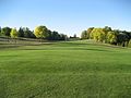
King's Forest Park is a park in Hamilton, Ontario. It was commissioned as part of the City Beautiful movement, spearheaded in Hamilton by the Hamilton Parks Board with the leadership of Thomas McQuesten. [1]

Contents

Environs

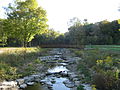
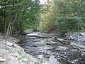
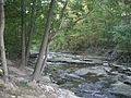
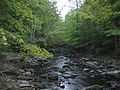
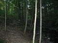
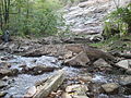
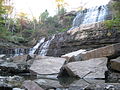
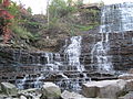
Albion Falls, a classical/cascade waterfall, and one of Hamilton's 100+ waterfalls, is at the back-end of King's Forest Park. A nearby parking lot was removed when the construction of the nearby Red Hill Valley Parkway started. A parking lot at Mountain Brow Road above the falls for 50+ cars is still available for visitors. [2] A small village called Albion Mills existed here until the early 1900s. The rocks from the Albion Falls area were used to construct the Rock Garden at the Royal Botanical Gardens. Another waterfall can be found nearby, northwest of Albion Falls called, Buttermilk Falls. Not too far off and just east of the newly built Red Hill Valley Parkway at the Glendale Golf & Country Club is another waterfall called Glendale Falls on Mount Albion Road. [3] [4]

King's Forest Golf Club was established in 1974 and is run by the city of Hamilton. The course is marked by Red Hill creek and many fair-sized ponds which come into play. [5]

1960s zoo proposal

In September 1961 the city's board of control authorized the formation of a zoo committee to look into the proposal of building a zoo at Kings Forest, an idea that had been mooted for the previous decade. [6] A site was selected at the south end of King's Forest, in the Red Hill Valley, and plans were drawn up in January 1963 by local architect Charles Lenz for a "Proposed Royal Zoological Park in the King's Forest". [6] His design incorporated moat- and rail- surrounded land animal enclosures surrounding ponds for birds, with a few small buildings for administration and suchlike and an encircling ring road with radial footpaths inwards therefrom. [7] As an attempt to mollify critics of zoos, which included the Citizens Against a Hamilton Zoo lobbying group, the zoo plans incorporated a new headquarters building for the SPCA. [8] The Board of Parks Management set aside 25 acres (10 ha) in April 1963 for the project. [8]

The project failed for two reasons. First, the city's budget was cut and could no longer afford the projected US$405,000(equivalent to $3,978,734 in 2023) cost of the initial phase of the zoo construction. [8] Second, the planned Red Hill Valley Parkway was re-routed in March 1964 over some of the land that had been set aside for the zoo, and in September 1964 the Board of Parks Management informed the zoo committee that the land not allocated for the Parkway was no longer going to be set aside for a zoo, because the Parkway plans plus the (then) proposed hydro-electric towers were already set to consume a sizeable chunk of Red Hill Valley. [9]

Images

See also

Related Research Articles

<span class="mw-page-title-main">Rouge River (Ontario)</span> River in Ontario, Canada

The Rouge River is a river in Markham, Pickering, Richmond Hill and Toronto in the Greater Toronto Area of Ontario, Canada. The river flows from the Oak Ridges Moraine to Lake Ontario at the eastern border of Toronto, and is the location of Rouge Park, the only national park in Canada within a municipality. At its southern end, the Rouge River is the boundary between Toronto and southwestern Pickering in the Regional Municipality of Durham.

<span class="mw-page-title-main">Buttermilk Falls State Park</span> State park in New York state, United States

Buttermilk Falls State Park is a 811-acre (3.28 km2) state park located southwest of Ithaca, New York, United States. Like Robert H. Treman State Park, a portion of the land that was to become the state park came from Robert and Laura Treman in 1924.

<span class="mw-page-title-main">Thomas McQuesten</span> Canadian politician

Thomas Baker McQuesten was a politician in Ontario, Canada. He was a Liberal member of the Legislative Assembly of Ontario from 1934 to 1943 who represented the riding of Hamilton—Wentworth. He served as a cabinet minister in the governments of Mitchell Hepburn and Gordon Conant.

<span class="mw-page-title-main">Lincoln M. Alexander Parkway</span> Municipal freeway in Hamilton, Ontario

The Lincoln M. Alexander Parkway, nicknamed The Linc, is a municipal expressway in the city of Hamilton, Ontario, Canada, which connects Highway 403 with the Red Hill Valley Parkway, which continues north to the Queen Elizabeth Way (QEW). Collectively, the two expressways form a southern and eastern bypass of Hamilton. Located on the Hamilton mountain, atop the Niagara Escarpment, the freeway was named after the former Progressive Conservative MP and first black Lieutenant Governor of Ontario, Lincoln Alexander in July 1997, despite him never holding a driver's license.

The Toronto and Region Conservation Authority (TRCA) is a conservation authority in southern Ontario, Canada. It owns about 16,000 hectares of land in the Toronto region, and it employs more than 400 full-time employees and coordinates more than 3,000 volunteers each year. TRCA's area of jurisdiction is watershed-based and includes 3,467 square kilometres (1,339 sq mi) – 2,506 on land and 961 water-based in Lake Ontario. This area comprises nine watersheds from west to east – Etobicoke Creek, Mimico Creek, Humber River, Don River, Highland Creek, Petticoat Creek, Rouge River, Duffins Creek and Carruthers Creek.

<span class="mw-page-title-main">Cleveland Metroparks</span> Public park system in Greater Cleveland, Ohio

Cleveland Metroparks is an extensive system of nature preserves in Greater Cleveland, Ohio. Eighteen reservations, which largely encircle the city of Cleveland, follow along the shore of Lake Erie and the rivers and creeks that flow through the region. Referred to unofficially as the 'Emerald Necklace', the network of parks spans over 25,000 acres (10,000 ha) and includes over 300 miles (480 km) of walking, bicycle, and horse trails as well as numerous picnic areas, nature education centers, golf courses, and countless fishing spots. In addition, the district includes the zoo in Cleveland. Four of the reservations are adjacent to Cuyahoga Valley National Park.

<span class="mw-page-title-main">Red Hill Valley Parkway</span> Municipal freeway in Hamilton, Ontario

The Red Hill Valley Parkway (RHVP) is a municipal expressway in the Canadian city of Hamilton, Ontario. The route connects the Lincoln M. Alexander Parkway, Hamilton's second municipal expressway, to the Queen Elizabeth Way (QEW) near Hamilton Harbour. It is named after Red Hill Valley, through which it descends the Niagara Escarpment. It is a 7-kilometre (4.3 mi) four-lane freeway with a speed limit of 80 kilometres per hour (50 mph).

<span class="mw-page-title-main">Hamilton Conservation Authority</span>

The Hamilton Conservation Authority maintains the greenspace, trails, parks and some attractions in Hamilton, Ontario, Canada.

This is a list of trails in Ithaca, New York.

<span class="mw-page-title-main">Red Hill Valley</span> Valley in Ontario, Canada

Red Hill Valley is a valley in eastern and south-eastern Hamilton, Ontario, Canada. The valley is named after and home to the Red Hill Creek, which flows 7 kilometres (4.3 mi) north-east from Albion Falls on the Niagara Escarpment, before bending north-west near the Queen Elizabeth Way and discharging into Hamilton Harbour at Windermere Basin. The name of the area comes from the reddish soil, rich with iron. The valley is estimated to be 1,600 acres (650 ha) in size. The Red Hill Valley was the site of a protracted battle over an expressway through the valley, ultimately constructed in 2007.

<span class="mw-page-title-main">Albion Falls</span> Waterfall in Hamilton, Ontario

Albion Falls is a 19 m (62 ft) classical/cascade waterfall flowing down the Niagara Escarpment in Red Hill Valley, in Hamilton, Ontario, Canada. With cascade falls the downpour is staggered into a series of steps causing water to "cascade". The top of the falls are located on Mountain Brow Blvd. The lower-end of the falls can be found at the south-end of King's Forest Park in lower Hamilton by following the Red Hill Creek south towards the Niagara Escarpment.

<span class="mw-page-title-main">Forest Preserve District of Cook County</span> Public land management agency in Illinois

The Forest Preserve District of Cook County is a governmental commission in Cook County, Illinois, that owns and manages land containing forest, prairie, wetland, streams, and lakes. These land holdings are primarily managed as undeveloped natural areas and for outdoor recreation. The Forest Preserve District encompasses approximately 70,000 acres of land or approximately 11% of the land in Cook County, which contains the city of Chicago and is the most densely populated urban metropolitan area in the Midwest. The Forest Preserves also owns the lands on which the Brookfield Zoo and the Chicago Botanic Garden operate.

<span class="mw-page-title-main">Geography of Hamilton, Ontario</span>

Hamilton is located on the western end of the Niagara Peninsula and wraps around the westernmost part of the Lake Ontario. Most of the city including the downtown section lies along the south shore. Situated in the geographic centre of the Golden Horseshoe, it lies roughly midway between Toronto and Buffalo. The two major physical features are Hamilton Harbour marking the northern limit of the city and the Niagara Escarpment running through the middle of the city across its entire breadth, bisecting the city into 'upper' and 'lower' parts.

<span class="mw-page-title-main">Dundurn Street (Hamilton, Ontario)</span>

Dundurn Street is a Lower City arterial road in Hamilton, Ontario, Canada. It is a two-way street that starts off at Mountain Face Park, Niagara Escarpment in front of the Bruce Trail as a collector road, right behind Hillcrest Avenue and then turns into a four lane thoroughfare from Aberdeen Avenue northward to York Boulevard where it ends in front of Dundurn Park.

<span class="mw-page-title-main">Centennial Parkway</span> Road in Hamilton, Ontario, Canada

Centennial Parkway is an arterial road in southeastern Hamilton, Ontario, Canada. It is best known as the western terminus of the former King's Highway 20, now maintained by the City of Hamilton. It starts off as Upper Centennial Parkway, a mountain-access road in the City right before the Canadian Pacific Railway line at the backend of Battlefield Park, and is a two-way street throughout that extends north over the Queen Elizabeth Way and ends at Beach Boulevard/Van Wagners Beach Road in front of Confederation Park.

<span class="mw-page-title-main">Barton Street (Hamilton, Ontario)</span> Arterial road in Hamilton, Ontario, Canada

Barton Street is an arterial road in the Lower City of Hamilton, Ontario, Canada. It's also the longest street (21.0 km) in the city. It starts at the north end of downtown at Locke Street North and is a two-way street that stretches eastward through a number of different and varied communities in the city and ends in Winona at Fifty Road just west of the Hamilton/Niagara regional boundary. The street is divided in East and West portions, divided by James Street. However, the East designation does not continue through the Stoney Creek district, which was a separate municipality prior to amalgamation in 2001, and the designation as well as the address numbering system were not restructured upon amalgamation, and numbers reset at the former city limits at Centennial Parkway.

<span class="mw-page-title-main">King Street, Hamilton, Ontario</span>

King Street is a Lower City arterial road in Hamilton, Ontario, Canada, also known as Highway 8. The western-end starts off beside McMaster University Medical Centre as a two-way street and passes through Westdale. At Paradise Road, King Street switches over to a one-way street (westbound) right through the city's core up to "the Delta", a spot in town where King and Main streets intersect. From the Delta onwards, King Street then switches over to become a two-way street again and ends at Highway 8 in Stoney Creek.

<span class="mw-page-title-main">Chedoke Creek</span>

The Chedoke Creek is an urban creek that runs through the west end of Hamilton, Ontario. It crosses the Bruce Trail and the Radial Trail.

Lower Westcliffe Falls is a 7.9-metre-high (26 ft) complex classic cascade waterfall found near the Chedoke Civic Golf Course in Hamilton, Ontario, Canada.

References

  1. Anderson 2006, pp. 15–16.
  2. "Albion Falls". (www.gowaterfalling.com). Retrieved 2007-04-18.
  3. "Albion Falls". Hamilton Conservation Authority. Archived from the original on 2007-04-07. Retrieved 2007-04-18.
  4. "Buttermilk Falls". Hamilton Conservation Authority. Archived from the original on 2007-04-08. Retrieved 2007-04-18.
  5. "King's Forest Golf Club". OntGolf.ca. Archived from the original on 2007-09-28. Retrieved 2007-04-18.
  6. 1 2 Osbaldeston 2016, p. 186.
  7. Osbaldeston 2016, pp. 186–187.
  8. 1 2 3 Osbaldeston 2016, p. 187.
  9. Osbaldeston 2016, pp. 187–188.

Bibliography

  • Anderson, Mary J., ed. (2006). The Life Writings of Mary Baker McQuesten: Victorian Matriarch Life Writing. Wilfrid Laurier University Press. ISBN   9780889205413.
  • Osbaldeston, Mark (2016). Unbuilt Hamilton: The City That Might Have Been. Dundurn. ISBN   9781459733008.