This article features a list of islands sorted by their name beginning with the letter W.

The geography of Antarctica is dominated by its south polar location and, thus, by ice. The Antarctic continent, located in the Earth's southern hemisphere, is centered asymmetrically around the South Pole and largely south of the Antarctic Circle. It is washed by the Southern Ocean or, depending on definition, the southern Pacific, Atlantic, and Indian Oceans. It has an area of more than 14.2 million km2. Antarctica is the largest ice desert in the world.

The Pitcairn Islands, officially the Pitcairn, Henderson, Ducie and Oeno Islands, are a group of four volcanic islands in the southern Pacific Ocean that form the sole British Overseas Territory in the Pacific Ocean. The four islands—Pitcairn, Henderson, Ducie and Oeno—are scattered across several hundred miles of ocean and have a combined land area of about 18 square miles (47 km2). Henderson Island accounts for 86% of the land area, but only Pitcairn Island is inhabited. The islands nearest to the Pitcairn Islands are Mangareva, 688 km to the west, and Easter Island, 1,929 km to the east.

The Arctic Archipelago, also known as the Canadian Arctic Archipelago, is an archipelago lying to the north of the Canadian continental mainland, excluding Greenland and Iceland.

The Hawaiian Islands are an archipelago of eight major volcanic islands, several atolls, and numerous smaller islets in the North Pacific Ocean, extending some 1,500 miles from the island of Hawaiʻi in the south to northernmost Kure Atoll. Formerly called the Sandwich Islands, the present name for the archipelago is derived from the name of its largest island, Hawaiʻi.
Call signs are frequently still used by North American broadcast stations, in addition to amateur radio and other international radio stations that continue to identify by call signs worldwide. Each country has a different set of patterns for its own call signs. Call signs are allocated to ham radio stations in Barbados, Canada, Mexico and the United States.
This gallery of sovereign state flags shows the national or state flags of sovereign states that appear on the list of sovereign states. For flags of other entities, please see gallery of flags of dependent territories. Each flag is depicted as if the flagpole is positioned on the left of the flag, except for those of Iran, Iraq and Saudi Arabia which are depicted with the hoist to the right.
This article lists extreme locations on Earth that hold geographical records or are otherwise known for their geophysical or meteorological superlatives. All of these locations are Earth-wide extremes; extremes of individual continents or countries are not listed.

Palmer Archipelago, also known as Antarctic Archipelago, Archipiélago Palmer, Antarktiske Arkipel or Palmer Inseln, is a group of islands off the northwestern coast of the Antarctic Peninsula. It extends from Tower Island in the north to Anvers Island in the south. It is separated by the Gerlache and Bismarck straits from the Antarctic Peninsula and Wilhelm Archipelago, respectively. The archipelago is in the British, Chilean, and Argentine Claims.

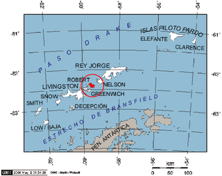
Robert Island or Mitchells Island or Polotsk Island or Roberts Island is an island 11 miles (18 km) long and 8 miles (13 km) wide, situated between Nelson Island and Greenwich Island in the South Shetland Islands, Antarctica. Robert Island is located at 62°24′S59°30′W. Its surface area is 132 km2 (51 sq mi). The name "Robert Island" dates back to around 1821 and is now established in international usage.

The Debelt Glacier on Varna Peninsula, Livingston Island in the South Shetland Islands, Antarctica is situated southeast of Rose Valley Glacier and northeast of Panega Glacier. It drains the southeastern slopes of Vidin Heights and flows into Moon Bay between Edinburgh Hill and Helis Nunatak. The glacier extends three km in an east-west direction, and 1.5 km in north-south direction.

Rose Valley Glacier is a glacier on Varna Peninsula, eastern Livingston Island in the South Shetland Islands, Antarctica situated northeast of Saedinenie Snowfield, northwest of Debelt Glacier and north of Panega Glacier. It extends 5.2 km in southeast-northwest direction and 3.7 km in southwest-northeast direction, and drains the northeast slopes of Vidin Heights to flow into Lister Cove and McFarlane Strait between Pomorie Point and Inott Point.

Wulfila Glacier is located on the southern slopes of Breznik Heights, Greenwich Island in the South Shetland Islands, Antarctica, south-southwest of Solis Glacier and west of Zheravna Glacier. It is bounded by Oborishte Ridge to the northwest, Nevlya Peak to the north, Terter Peak and Razgrad Peak to the northeast, and Ephraim Bluff to the southeast. The glacier extends 3 km in northwest–southeast direction and 2 km in northeast–southwest direction. It drains southwestwards into McFarlane Strait between Ephraim Bluff and the base of Provadiya Hook, feeding the head of Doris Cove.

Quito Glacier is a glacier draining the northeast slopes of Mount Plymouth and flowing northeastwards into the sea west of Canto Point in north Greenwich Island, South Shetland Islands. It was named after the capital of Ecuador, c. 1990, by the Ecuadorian Antarctic Expedition.

Sint Maarten is a constituent country of the Kingdom of the Netherlands in the Caribbean. With a population of 41,486 as of January 2019 on an area of 34 km2 (13 sq mi), it encompasses the southern 44% of the divided island of Saint Martin, while the northern 56% of the island constitutes the French overseas collectivity of Saint Martin. Sint Maarten's capital is Philipsburg. Collectively, Sint Maarten and the other Dutch islands in the Caribbean are often called the Dutch Caribbean.

Chumerna Glacier is the 2.2 km long and 1.9 km wide glacier draining the north slopes of Stavertsi Ridge on Albena Peninsula, Brabant Island in the Palmer Archipelago, Antarctica. It flows northeastwards to enter the channel between Brabant Island and Liège Island east of Hales Peak.

Argentina Glacier is a glacier flowing northwest from Hurd Dome and terminating near Argentina Cove, South Bay, on Livingston Island, in the South Shetland Islands. The name Argentina Glacier was given in association with Argentina Cove by the Spanish Antarctic Expedition, about 1995.