List of most isolated mountains of Switzerland

Last updated
Map all coordinates using: OpenStreetMap  ·  Google Maps
Download coordinates as: KML  ·  GPX

This is a list of the most topographically isolated mountains of Switzerland. This list only includes summits with an isolation of at least 10.0 kilometres (6.2 mi), regardless of their elevation or topographical prominence (drop). For a general list of mountains, with height and prominence ranking, see List of mountains of Switzerland.
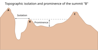
Topographic isolation

The topographic isolation of a summit is the minimum great-circle distance to a point of equal elevation, representing a radius of dominance in which the peak is the highest point. It can be calculated for small hills and islands as well as for major mountain peaks, and can even be calculated for submarine summits.

Mountain A large landform that rises fairly steeply above the surrounding land over a limited area

A mountain is a large landform that rises above the surrounding land in a limited area, usually in the form of a peak. A mountain is generally steeper than a hill. Mountains are formed through tectonic forces or volcanism. These forces can locally raise the surface of the earth. Mountains erode slowly through the action of rivers, weather conditions, and glaciers. A few mountains are isolated summits, but most occur in huge mountain ranges.

Switzerland federal republic in Central Europe

Switzerland, officially the Swiss Confederation, is a country situated in western, central, and southern Europe. It consists of 26 cantons, and the city of Bern is the seat of the federal authorities. The sovereign state is a federal republic bordered by Italy to the south, France to the west, Germany to the north, and Austria and Liechtenstein to the east. Switzerland is a landlocked country geographically divided between the Alps, the Swiss Plateau and the Jura, spanning a total area of 41,285 km2 (15,940 sq mi). While the Alps occupy the greater part of the territory, the Swiss population of approximately 8.5 million people is concentrated mostly on the plateau, where the largest cities are to be found: among them are the two global cities and economic centres Zürich and Geneva.

Contents

The list includes all eight ultra-prominent peaks of Switzerland as well as several canton high points.
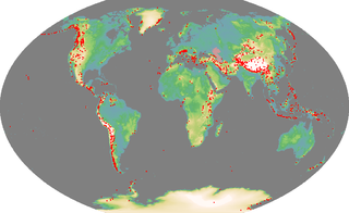
Ultra-prominent peak

An ultra-prominent peak, or Ultra for short, is a mountain summit with a topographic prominence of 1,500 metres (4,900 ft) or more; it is also called a P1500. There are approximately 1,524 such peaks on Earth. Some well-known peaks, such as the Matterhorn and Eiger, are not Ultras because they are connected to higher mountains by high cols and therefore do not achieve enough topographic prominence.

List

RankMountain [1] Height (m)Isolation (km) Drop (m)CoordinatesRange Canton(s)
1 Piz Bernina 4049137.82234 46°22′56″N09°54′29″E / 46.38222°N 9.90806°E / 46.38222; 9.90806 Bernina Range Graubünden
2 Monte Rosa 463478.32165 45°56′13″N07°52′01″E / 45.93694°N 7.86694°E / 45.93694; 7.86694 Pennine Alps Valais
3 Finsteraarhorn 427451.72280 46°32′15″N08°07′34″E / 46.53750°N 8.12611°E / 46.53750; 8.12611 Bernese Alps Bern/Valais
4 Chasseral 160649.5666 47°09′59″N07°03′34″E / 47.16639°N 7.05944°E / 47.16639; 7.05944 Jura Mountains Bern
5 Tödi 361442.11570 46°48′40″N08°54′53″E / 46.81111°N 8.91472°E / 46.81111; 8.91472 Glarus Alps Glarus/Graubünden
6 Mont Tendre 167938.7451 46°35′41″N06°18′36″E / 46.59472°N 6.31000°E / 46.59472; 6.31000 Jura Mountains Vaud
7 Rheinwaldhorn 340235.11337 46°29′37″N09°02′24″E / 46.49361°N 9.04000°E / 46.49361; 9.04000 Lepontine Alps Graubünden/Ticino
8 Le Chasseron 160732.0590 46°51′06″N06°32′19″E / 46.85167°N 6.53861°E / 46.85167; 6.53861 Jura Mountains Vaud
9 Schesaplana 296430.3826 47°03′14″N09°42′26″E / 47.05389°N 9.70722°E / 47.05389; 9.70722 Rätikon Graubünden
10 Ringelspitz 324829.8844 46°53′59″N09°20′39″E / 46.89972°N 9.34417°E / 46.89972; 9.34417 Glarus Alps Graubünden/St. Gallen
11 Hasenmatt 144529.6618 47°14′31″N07°27′02″E / 47.24194°N 7.45056°E / 47.24194; 7.45056 Jura Mountains Solothurn
12 Grand Combin 431426.41517 45°56′15″N07°17′57″E / 45.93750°N 7.29917°E / 45.93750; 7.29917 Pennine Alps Valais
13 Säntis 250225.72021 47°14′58″N09°20′36″E / 47.24944°N 9.34333°E / 47.24944; 9.34333 Appenzell Alps Appenzell A./Appenzell I./St. Gallen
14 Piz Linard 301024.91027 46°47′56″N10°04′17″E / 46.79889°N 10.07139°E / 46.79889; 10.07139 Silvretta Alps Graubünden
15 Piz Kesch 341822.91503 46°37′17″N09°52′21″E / 46.62139°N 9.87250°E / 46.62139; 9.87250 Albula Alps Graubünden
16 Wildhorn 324822.9978 46°21′17″N07°21′39″E / 46.35472°N 7.36083°E / 46.35472; 7.36083 Bernese Alps Bern/Valais
17 Dammastock 363021.61466 46°38′37″N08°25′16″E / 46.64361°N 8.42111°E / 46.64361; 8.42111 Uri Alps Bern/Uri
18 Piz Sesvenna 320421.51055 46°42′22″N10°24′11″E / 46.70611°N 10.40306°E / 46.70611; 10.40306 Sesvenna Alps Graubünden
19 Dents du Midi 325719.01796 46°09′40″N06°55′24″E / 46.16111°N 6.92333°E / 46.16111; 6.92333 Chablais Alps Valais
20 Cornettes de Bise 243218.21063 46°19′57″N06°47′04″E / 46.33250°N 6.78444°E / 46.33250; 6.78444 Chablais Alps Valais
21 Pizzo Campo Tencia 307217.5754 46°25′47″N08°43′34″E / 46.42972°N 8.72611°E / 46.42972; 8.72611 Lepontine Alps Ticino
22 Pizzo Tambo 327916.91164 46°29′49″N09°17′00″E / 46.49694°N 9.28333°E / 46.49694; 9.28333 Oberhalbstein Alps Graubünden
23 Dom 454516.81046 46°05′42″N07°51′36″E / 46.09500°N 7.86000°E / 46.09500; 7.86000 Pennine Alps Valais
24 Pilatus 212816.7585 46°58′26″N08°14′28″E / 46.97389°N 8.24111°E / 46.97389; 8.24111 Emmental Alps Nidwalden/Obwalden
25 Piz Calderas 339716.51085 46°32′11″N09°41′46″E / 46.53639°N 9.69611°E / 46.53639; 9.69611 Albula Alps Graubünden
26 Lägern 86616.4425 47°28′54″N08°23′41″E / 47.48167°N 8.39472°E / 47.48167; 8.39472 Jura Mountains Zurich
27 Lindenberg 87816.3358 47°15′13″N08°17′35″E / 47.25361°N 8.29306°E / 47.25361; 8.29306 Lindenberg Lucerne
28 Seerücken (Büürer Holz) 72116.1268 47°38′56″N09°02′00″E / 47.64889°N 9.03333°E / 47.64889; 9.03333 Seerücken Thurgau
29 Fluchthorn 339815.6646 46°53′27″N10°13′39″E / 46.89083°N 10.22750°E / 46.89083; 10.22750 Silvretta Alps Graubünden
30 Piz Medel 321015.4942 46°37′05″N08°54′40″E / 46.61806°N 8.91111°E / 46.61806; 8.91111 Lepontine Alps Graubünden/Ticino
31 Piz Murtaröl 318015.1679 46°34′14″N10°17′15″E / 46.57056°N 10.28750°E / 46.57056; 10.28750 Ortler Alps Graubünden
32 Le Soliat 146414.9204 46°55′43″N06°43′29″E / 46.92861°N 6.72472°E / 46.92861; 6.72472 Jura Mountains Neuchâtel
33 Irchel 69414.9260 47°32′22″N08°36′26″E / 47.53944°N 8.60722°E / 47.53944; 8.60722 Jura Mountains Zurich
34 Gridone 218814.41218 46°07′24″N08°38′53″E / 46.12333°N 8.64806°E / 46.12333; 8.64806 Lepontine Alps Ticino
35 Monte Generoso 170114.41321 45°55′53″N09°01′12″E / 45.93139°N 9.02000°E / 45.93139; 9.02000 Lugano Prealps Ticino
36 Diablerets 321014.3968 46°18′14″N07°11′21″E / 46.30389°N 7.18917°E / 46.30389; 7.18917 Bernese Alps Valais/Vaud
37 Glärnisch 291514.3967 46°59′55″N08°59′55″E / 46.99861°N 8.99861°E / 46.99861; 8.99861 Schwyz Alps Glarus
38 La Dôle 167713.9355 46°25′30″N06°05′58″E / 46.42500°N 6.09944°E / 46.42500; 6.09944 Jura Mountains Vaud
39 Matterhorn 447813.81040 45°58′35″N07°39′30″E / 45.97639°N 7.65833°E / 45.97639; 7.65833 Pennine Alps Valais
40 Bruschghorn 305613.8577 46°37′52″N09°18′24″E / 46.63111°N 9.30667°E / 46.63111; 9.30667 Lepontine Alps Graubünden
41 Chutzen 82013.6261 47°00′53″N07°19′26″E / 47.01472°N 7.32389°E / 47.01472; 7.32389 Chutzen Bern
42 Aroser Rothorn 298013.51349 46°44′16″N09°36′50″E / 46.73778°N 9.61389°E / 46.73778; 9.61389 Plessur Alps Graubünden
43 Bietschhorn 393413.4806 46°23′29″N07°51′03″E / 46.39139°N 7.85083°E / 46.39139; 7.85083 Bernese Alps Valais
44 Monte Tamaro 196213.31408 46°06′14″N08°51′58″E / 46.10389°N 8.86611°E / 46.10389; 8.86611 Lugano Prealps Ticino
45 Rigi 179813.11290 47°03′24″N08°29′08″E / 47.05667°N 8.48556°E / 47.05667; 8.48556 Schwyz Alps Schwyz
46 Aletschhorn 419312.91029 46°27′54″N07°59′37″E / 46.46500°N 7.99361°E / 46.46500; 7.99361 Bernese Alps Valais
47 Blinnenhorn 337412.8945 46°25′33″N08°18′29″E / 46.42583°N 8.30806°E / 46.42583; 8.30806 Lepontine Alps Valais
48 Oberalpstock 332812.7709 46°44′33″N08°46′10″E / 46.74250°N 8.76944°E / 46.74250; 8.76944 Glarus Alps Graubünden/Uri
49 Balmhorn 369812.31022 46°25′30″N07°41′37″E / 46.42500°N 7.69361°E / 46.42500; 7.69361 Bernese Alps Bern/Valais
50 Schafberg 223911.8735 46°38′13″N07°19′01″E / 46.63694°N 7.31694°E / 46.63694; 7.31694 Bernese Alps Bern/Fribourg
51 Monte Leone 355311.71144 46°14′59″N08°06′37″E / 46.24972°N 8.11028°E / 46.24972; 8.11028 Lepontine Alps Valais
52 Piz Platta 339211.71108 46°29′13″N09°33′42″E / 46.48694°N 9.56167°E / 46.48694; 9.56167 Oberhalbstein Alps Graubünden
53 Muttler 329311.5703 46°54′02″N10°22′43″E / 46.90056°N 10.37861°E / 46.90056; 10.37861 Samnaun Alps Graubünden
54 Weissfluh 284311.5497 46°50′07″N09°47′40″E / 46.83528°N 9.79444°E / 46.83528; 9.79444 Plessur Alps Graubünden
55 Gamsberg 238511.51358 47°08′07″N09°22′28″E / 47.13528°N 9.37444°E / 47.13528; 9.37444 Appenzell Alps St. Gallen
56 Weisshorn 450611.01235 46°06′06″N07°42′58″E / 46.10167°N 7.71611°E / 46.10167; 7.71611 Pennine Alps Valais
57 Weissmies 401711.01185 46°07′40″N08°00′43″E / 46.12778°N 8.01194°E / 46.12778; 8.01194 Pennine Alps Valais
58 Bürglen (Albis) 91511.0375 47°15′28″N08°32′14″E / 47.25778°N 8.53722°E / 47.25778; 8.53722 Albis Zurich
59 Basòdino 327310.9960 46°24′42″N08°28′07″E / 46.41167°N 8.46861°E / 46.41167; 8.46861 Lepontine Alps Ticino
60 Napf 140810.5552 47°00′15″N07°56′24″E / 47.00417°N 7.94000°E / 47.00417; 7.94000 Emmental Alps Bern/Lucerne
61 Piz Quattervals 316510.4471 46°37′38″N10°05′42″E / 46.62722°N 10.09500°E / 46.62722; 10.09500 Livigno Alps Graubünden
62 Vanil Noir 238910.41110 46°31′43″N07°08′54″E / 46.52861°N 7.14833°E / 46.52861; 7.14833 Bernese Alps Fribourg/Vaud
63 Piz Pisoc 317310.3922 46°44′40″N10°16′47″E / 46.74444°N 10.27972°E / 46.74444; 10.27972 Sesvenna Alps Graubünden
64 Pizzo Paglia 259310.3498 46°13′55″N09°13′09″E / 46.23194°N 9.21917°E / 46.23194; 9.21917 Lepontine Alps Graubünden
65 Montagne du Château 92910.3249 46°34′51″N06°42′57″E / 46.58083°N 6.71583°E / 46.58083; 6.71583 Jorat Vaud
66 Mont Vully 65310.3173 46°57′50″N07°05′38″E / 46.96389°N 7.09389°E / 46.96389; 7.09389 Mont Vully Fribourg
67 Piz Timun 320910.2823 46°28′01″N09°24′34″E / 46.46694°N 9.40944°E / 46.46694; 9.40944 Oberhalbstein Alps Graubünden
68 Pizzo Rotondo 319210.0752 46°31′01″N08°27′57″E / 46.51694°N 8.46583°E / 46.51694; 8.46583 Lepontine Alps Ticino/Valais

Related Research Articles

In topography, prominence measures the height of a mountain or hill's summit relative to the lowest contour line encircling it but containing no higher summit within it. It is a measure of the independence of a summit. A peak's key col is a unique point on this contour line and the parent peak is some higher mountain, selected according to various objective criteria.

References

  1. All mountain heights and prominences are from the 1:25,000 Swisstopo topographic maps. Topographic isolations were retrieved from the Google Earth geographical information program.