Longley, Sheffield

Last updated

Typical Longley estate housing on Piper Road. Longley housing.jpg
Typical Longley estate housing on Piper Road.

Longley is a suburb of the City of Sheffield, in South Yorkshire, England. It lies four km north of the city centre and is a residential neighbourhood made up mostly of housing built by Sheffield City Council in the late 1920s. The suburb falls within the Firth Park ward of the City.

Contents

History

The recorded history of the Longley area goes back to the Late Middle Ages with the first mention being in 1366 when it was part of the parish of Ecclesfield. At that time it was a hamlet called “Longeley”, meaning “Long Clearing”, subsequent spellings over the years were “Longlegh” and “Longlee”. From the start of the 15th century the sparse population of Longley rented their land from the Earl of Shrewsbury who was Lord of the Manor. During this time the inhabitants were mostly employed in arable and livestock farming although there was also some small scale cutlery manufacturing.

In 1617 Longley came under the ownership of Thomas Howard, 21st Earl of Arundel, a member of the family who later became the Dukes of Norfolk. With the onset of the Industrial Revolution the agricultural nature of Longley became threatened as the farms found it harder to be profitable and the expanding industry of Sheffield came ever closer. In the early part of the 20th century Longley became within the boundary of the City of Sheffield and was earmarked as a site for a council housing estate and the rural life disappeared altogether.

Significant historic buildings

The Longley area had a number of large country houses before it became part of Sheffield, most of these have now been demolished.

Sheffield outline map with UK.svg
Red pog.svg
Longley shown within Sheffield

Longley Hall

Longley Hall is well screened from the road. Longley Hall.jpg
Longley Hall is well screened from the road.

Longley Hall stands on Longley Lane at its junction with Crowder Road, it was built around 1780 for Kenyon Parker a renowned and wealthy Sheffield law attorney. It is a Grade two listed building which became the target of vandals throughout the 1970s. In 1980 the hall was purchased by Business Advisory Services Ltd. who restored the building to a high standard inside and out. Today the Hall is owned by a private landlord, and operated as a Supported living project providing a home for people with a range of disabilities. It is surrounded by modern housing and well screened and is easily missed by the passer-by although there is a plaque on the wall on Longley Lane.

Longley Hall Farm was adjacent to the Hall on what is now Crowder Road. Between 1906 and the 1950s the farm produced fresh milk, meat and vegetables for the nearby Northern General Hospital. The farm was demolished in 1969 and its land was used for housing.

Crowder House

Crowder House was situated on what is now Crowland Road, it had extensive grounds, some of which were incorporated into Longley Park. It is the oldest of Longley’s country houses with a history going back to at least 1402 when it was mentioned in the transfer of deeds. The house was the property of the Wilkinson family for over 300 years until May 1855 when the family were ejected, after a lessee went bankrupt. The family still had connections with the house until 1859 when Bernard Wake, a solicitor, purchased it. The house was demolished in 1935 being replaced by the new housing on Crowland Road.

Longley Park Sixth Form now stands on the site of The Brushes. Longley Park 6th Form College.jpg
Longley Park Sixth Form now stands on the site of The Brushes.

The Brushes

The Brushes was located at the junction of Longley Lane and Barnsley Road. It was built in 1790, however Brushes Farm existed on the site in the 1640s, at the time of the English Civil War when its first resident Captain Burley was executed in 1646 for siding with the Royalists. The Booth family bought the farm in 1708 and John Booth who had made his wealth through iron and steel production built The Brushes mansion next to the farm in 1790. Charles Kayser became the owner in 1888 and he demolished the farm and built a castellated tower to complement the mansion. In 1920 the building became Firth Park Grammar School after being purchased by Sheffield Corporation for £22,000. The building was demolished in 2002-03 and Longley Park Sixth Form now stands in its place. [1]

Norwood Grange

Norwood Grange stands at the junction of Herries Road and Longley Lane. It is a gabled house built in the 1850s for Thomas Fisher, a partner in the Britannia metal company of Shaw and Fisher. After a succession of owners the Grange was purchased by Sheffield Council just before World War II. During the conflict it was used by the Auxiliary Fire Service and Air Raid Wardens as a base. The house fell into a dilapidated state in the post war years. In the early 1990s the main house was restored and extended and turned into Norwood Grange Residential Home. Some of the outbuildings are still in a run down state.

Cliffe House

Norwood Grange has been renovated and is now a residential care home. Norwood Grange, Longley.jpg
Norwood Grange has been renovated and is now a residential care home.

Cliffe House stood on Elm Lane at the site which is now Elm Lane Fire Station. The house was built in 1805 by Sarah Booth of The Brushes. In 1934 it became The Cliffe Institute for Mental Defectives. In 1938 the Fire Station was built on the extensive grounds while the house remained standing and was used as quarters for the firemen. The house was demolished immediately after World War II and the land was used for housing, with the houses on Hereward Road being built on the site. [2]

Modern times

In the early part of the 1920s Sheffield City Council started buying up land in the area from local land-owners. On 10 June 1926 the Council’s plans for 2,000 new houses at Longley were endorsed and tenants started moving into the completed dwellings in 1927. A school was built for the new estate on Raisen Hall Road with the official opening ceremony taking place on 17 July 1930, it accommodated over 400 children when first opened. Longley Park was officially opened in 1929 to serve as a recreation area for the new estate.

Present day Longley has a population of 6,190 living in 2,642 households. 53.3% of Longley’s houses are rented from the local authority, well above Sheffield’s average of 26.5%. [3] One of the newest housing developments in Longley has been the building of 20 bungalows for the elderly on Everingham Place by the South Yorkshire Housing Association. The development which has two of the bungalows specifically designed for the disabled opened in December 2003. [4]

The National Blood Service has its regional headquarters in Longley, the centre on Longley Lane processes, tests and stores blood donations from the South Yorkshire area. The Longley area does not have any public houses strictly within its boundaries, the nearest one being the Devonshire Arms on Herries Road which is in the adjacent district of Shirecliffe. The area had its own ecclesial parish created in 1929 called St Leonards, Norwood. The foundation stone for a new church on Everingham Road was laid in July 1939, however because of World War II it was not completed and consecrated until May 1950. [5]

Related Research Articles

<span class="mw-page-title-main">Wortley, Leeds</span> Human settlement in England

Wortley is an inner city area of Leeds, West Yorkshire, England. It begins one mile to the west of the city centre. The appropriate City of Leeds ward is called Farnley and Wortley.

<span class="mw-page-title-main">West Park, Leeds</span> Human settlement in England

West Park is a suburb of north-west Leeds, West Yorkshire, England, north of Headingley. It is a mixed area of private suburban housing and suburban council estates. The name derives from its main park containing playing fields together with a conservation area of grassy meadow ending in woodland. The largest housing estate in West Park is Moor Grange.

<span class="mw-page-title-main">Rossington</span> Civil parish and former mining village in South Yorkshire, England

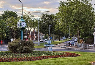
Rossington is a civil parish and former mining village in the Metropolitan Borough of Doncaster in South Yorkshire, England and is surrounded by countryside and the market towns of Bawtry and Tickhill.

<span class="mw-page-title-main">Worrall</span> Village in South Yorkshire, England

Worrall is a small rural village in the civil parish of Bradfield, South Yorkshire, England, 4 miles (6.5 km) north west of Sheffield city centre. It has an area of 233 hectares, and population of 1,306 as of 2006, and borders the Sheffield suburbs of Wadsley, Middlewood and Loxley to the south and east and the adjoining village of Oughtibridge to the north; to the west is a rural area extending towards the village of High Bradfield.

<span class="mw-page-title-main">Totley</span> Suburb of Sheffield in South Yorkshire, England

Totley is a suburb on the extreme southwest of the city of Sheffield, in South Yorkshire, England. Lying within the historic county boundaries of Derbyshire, Totley was amalgamated into the city of Sheffield in 1933, and is today part of the Dore and Totley electoral ward in the city, though it remains close to the contemporary county boundary of Derbyshire. Totley had a population of 7,963 in 2011.

<span class="mw-page-title-main">Beauchief and Greenhill</span> Electoral ward in the City of Sheffield, South Yorkshire, England

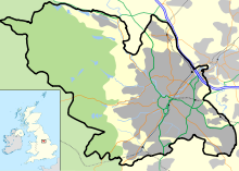
Beauchief and Greenhill ward—which includes the districts of Batemoor, Beauchief, Chancet Wood, Greenhill, Jordanthorpe, Lowedges and Meadowhead—is one of the 28 electoral wards in the City of Sheffield, England. It is in the southern part of the city and covers an area of 2.4 square miles (6.2 km2). The population of the ward in 2016 was estimated to be 19,669 people in 9,209 houses.

<span class="mw-page-title-main">Richmond, Sheffield</span> Suburb and electoral ward in the City of Sheffield, South Yorkshire, England

Richmond is a suburb of Sheffield in South Yorkshire, England. It lies in the eastern part of the city.

<span class="mw-page-title-main">Whirlow</span> Suburb of Sheffield, South Yorkshire, England

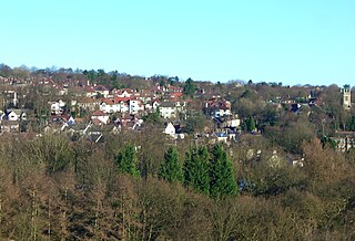
Whirlow is a suburb of the City of Sheffield in England, it lies 3.7 miles (6 km) south-west of the city centre. The suburb falls within the Dore and Totley ward of the City. It is one of the most affluent areas of Sheffield, with much high class housing and several notable small country houses within it. During the Victorian era it was home to some of Sheffield's most influential citizens. Whirlow straddles the A625, the main Sheffield to Hathersage road. The suburb covers the area from Parkhead in the north to Whirlow Bridge in the south and from Ecclesall Woods in the east to Broad Elms Lane in the west. Whirlow had a population of 1,663 in 2011.

<span class="mw-page-title-main">Firth Park (ward)</span> Electoral ward in the City of Sheffield, South Yorkshire, England

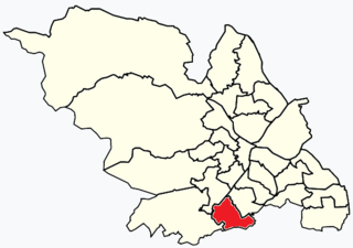
Firth Park ward—which includes the districts of Firth Park, Longley, Parson Cross and parts of Wincobank—is one of the 28 electoral wards in City of Sheffield, England located in the northern part of the city and covering an area of 1.66 square miles (4.3 km2). The population of this ward in 2011 was 21,141 people in 8,602 households.

<span class="mw-page-title-main">Willerby, East Riding of Yorkshire</span> Village and civil parish in the East Riding of Yorkshire, England

Willerby is a village and civil parish located on the western outskirts of the city of Kingston upon Hull in the East Riding of Yorkshire, England.

<span class="mw-page-title-main">Moor Grange</span> Human settlement in England

Moor Grange Estate is a housing estate in the West Park area of Leeds, West Yorkshire, England, which was built in the 1950s on reclaimed farmland. Work on the Moor Grange Estate began in 1955. It was originally owned by the local council, and was leased by the council to tenants as a council estate. Most of the housing on the estate is now privately owned. Moor Grange does not suffer the crime problems of other council estates. House prices on the estate are high, and Moor Grange is considered a 'model council estate'. This may be due to the affluence of the area in which it is situated. Moor Grange backs onto the smaller Spen Estate which is another council estate in West Park. The Estate falls within the Kirkstall ward of the Leeds Metropolitan Council.

Middlewood is a north western suburb of Sheffield, South Yorkshire, England. The suburb falls within the Stannington ward of the City.

Formal education in Sheffield, England, takes place at the city's two universities, 141 primary schools and 28 secondary schools.

<span class="mw-page-title-main">Grangewood Park</span> Park in the United Kingdom

Grangewood Park is an extensive woodland area situated in South Norwood, London. It is managed by the London Borough of Croydon. It is bounded by Grange Road, Wharncliffe Road, and Ross Road. It covers an area of 27.7 acres. The park is located on the main A212 road between Thornton Heath and Upper Norwood/Crystal Palace. The nearest stations are Thornton Heath, Selhurst and Norwood Junction.

<span class="mw-page-title-main">Cliffe Vale, Staffordshire</span> Human settlement in England

Cliff Vale is a district of the city of Stoke-on-Trent, and lies to the immediate south of Etruria and just east of Basford and Hartshill. Cliffe Vale is in the valley of the Fowlea Brook, now better known as Etruria Valley. There are industrial and employment uses along the A500, and new residential developments along the Trent and Mersey Canal. The Shelton New Road (B5045) passes through from east to west. The area is sometimes called Cliff Vale by the city council, and is part of the Hartshill electoral ward.

<span class="mw-page-title-main">Longley Park</span> Public park in Sheffield, South Yorkshire, England

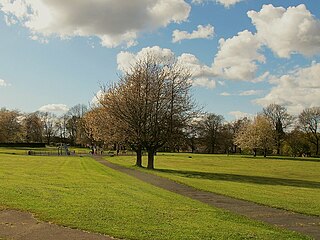
Longley Park is a public park within the City of Sheffield, South Yorkshire, England. The park lies between the suburbs of Longley and Firth Park, four km north of the city centre. It covers an area of just under 52 acres and is the third largest public park in Sheffield.

Wisewood is a suburb of the city of Sheffield in South Yorkshire, England and situated 2+34 miles (4.4 km) north-west of the city centre. It is a residential suburb consisting almost exclusively of council housing, some of which has been bought by tenants under the right to buy scheme. It is bordered by the adjacent suburbs of Loxley, Wadsley, Malin Bridge and Hillsborough.

Page Hall is a suburb of north-eastern Sheffield, South Yorkshire, England. It falls within the Burngreave ward of the city is surrounded by the suburbs of Fir Vale, Firth Park, Grimesthorpe and Pitsmoor.

<span class="mw-page-title-main">Firth Park (public park)</span>

Firth Park is a public park in the Firth Park area of the City of Sheffield in England. It is located 2.33 miles (3.75 km) north-northeast of the city centre. The main entrance to the park is on Hucklow Road although there are several entrances on Firth Park Road to the east and one on Vivian Road to the south. Established in 1875, the park gave its name to the Sheffield suburb of Firth Park, a social housing estate constructed around the area of the park in the 1920s and 1930s.

<span class="mw-page-title-main">Fulwood, Sheffield</span> Suburb of Sheffield in South Yorkshire, England

Fulwood is a residential suburb and ward of the City of Sheffield in England, it lies 5.5 km west-southwest of the city centre. Formerly an ancient settlement and village on the Porter Brook, it became integrated into the city in the 1930s. It is bounded by the suburbs of Lodge Moor to the NW, Ranmoor to the east and Crosspool to the NE. The open countryside of the Peak District lies to the west and SW. The sub districts of Stumperlowe and Goole Green are part of the suburb. The population of the ward at the 2011 Census was 18,233. Fulwood is located in the Sheffield Hallam constituency which, as of the 2019 general election voted Labour.

References

  1. Firth Park Grammar School website. Archived 2008-07-24 at the Wayback Machine Gives details of The Brushes.
  2. "It Was All Country Then", Sylvia Anginotti (editor), No ISBN, Gives history and details of old country houses.
  3. Longley Neighbourhood Profile 2005/06 . Archived 2011-10-07 at the Wayback Machine Gives statistics for 2005/06.
  4. South Yorkshire Housing Association. Archived 2009-01-01 at the Wayback Machine Gives details of development of Everingham Place.
  5. "A Home Of Our Own", Sylvia Anginotti (editor), No ISBN Gives modern history.

53°25′02″N1°28′14″W / 53.4172°N 1.4706°W / 53.4172; -1.4706