Los Angeles's 11th City Council district

Last updated

Los Angeles's 11th
City Council district
Flag of Los Angeles, California.svg
Los Angeles City Council District 11.svg
Councilmember
  Traci Park
D Venice
Demographics60.1%  White
5.2%  Black
18.7%  Hispanic
11.6%  Asian
0.4% Other
Population (2020)284,600
Registered voters (2017)171,819
Website councildistrict11.lacity.gov

Los Angeles's 11th City Council district is one of the fifteen districts in the Los Angeles City Council. It is currently represented by Democrat Traci Park since 2022, who succeeded Mike Bonin after his retirement.

Contents

The district was created in 1925 after a new city charter was passed, which replaced the former "at large" voting system for a nine-member council with a district system with a 15-member council. The 11th District originally encompassed an area south of Downtown before being moved to the Venice area in 1928, where it has stayed since. [1] [2] It is the largest district in the Los Angeles City Council.

Geography

The 11th District is bounded by Mulholland Drive on the north, the Pacific Ocean on the west, Imperial Highway on the south and roughly the 405 freeway on the east. The district covers all or a portion of the following: Brentwood, Del Rey, Mar Vista, Marina del Rey, Pacific Palisades, Palms, Playa del Rey, Playa Vista, Sawtelle, Venice, West Los Angeles, Westchester and the Los Angeles International Airport. [3]

The district overlaps California's 36th congressional district and California's 32nd congressional district as well as California's 24th and 35th State Senate districts and California's 42nd and 62nd State Assembly districts.

Historical boundaries

In 1925, when it was first mapped, it covered an area just south of Downtown, but three years later it was transferred to the Westside of the city. It originally had the district headquarters at 431 West Seventh Street, the present site of the Los Angeles Athletic Club. [4] [5] In 1928, the district was moved from the downtown section of the city and transplanted to the coast region. [6] By 1933, it was scattered area due to its inclosure of county territory. Its eastern boundary is La Brea Avenue, its north boundary is Pico Boulevard, its southern boundary the city limits and its western boundary the ocean. [7] [8] [9] [10] In 1957, it had parts of West Los Angeles, Westwood, Pacific Palisades, Brentwood, Mar Vista and Palms. [11] [12] In 1960, Venice was shifted into the district from the 6th District. [13]

In 1971, it had Pacific Palisades, Brentwood, and West Los Angeles with sections of Tarzana, Encino, Rancho Park, Westdale, Mar Vista and Venice. [14] By 1997, it had 73 square miles, bisected by the Santa Monica Mountains, include ritzy hillside enclaves stretching from Woodland Hills to Encino, Pacific Palisades to Brentwood. Poorer parts of Van Nuys and the West Los Angeles flatlands are included as well. [15]

List of members representing the district

CouncilmemberPartyDatesElectoral history
District established July 1, 1925
Peirson Mitchell Hall, 1928.jpg
Peirson M. Hall
(Westlake)
Democratic July 1, 1925 –
June 30, 1929
Elected in 1925.
Re-elected in 1927.
Retired.
J. C. Barthel, 1931.png
J. C. Barthel
(Castle Heights)
Republican July 1, 1929 –
June 30, 1931
Elected in 1929.
Lost re-election.
Clarence E. Coe, 1931.jpg
Clarence E. Coe
(Palms)
Republican July 1, 1931 –
June 30, 1933
Elected in 1931.
Lost re-election.
Charles-Winchester-Breedlove-1930s.tiff
Charles W. Breedlove
(West Adams)
Democratic July 1, 1933 –
April 26, 1934
Elected in 1933.
Died. [16]
VacantApril 26, 1934 –
June 11, 1934
Robert S. MacAlister, 1935.jpg
Robert S. MacAlister
(Faircrest Heights)
Democratic June 11, 1934 –
June 30, 1939
Appointed to finish Breedlove's term. [17]
Elected in 1935.
Re-elected in 1937.
Lost re-election.
Harold Harby, 1937.jpg
Harold Harby
(Reynier Village)
Democratic July 1, 1939 –
January 12, 1942
Elected in 1939.
Re-elected in 1941.
Removed from office. [18]
VacantJanuary 12, 1942 –
May 18, 1942
Dave-Stannard-of-Los-Angeles.tiff
Dave Stannard
(West Adams)
Democratic May 18, 1942 –
June 30, 1943
Appointed to finish Harby's term. [19]
Lost election.
City councilman Harold V. Harby debating merits of Edmond Kohn's "Bird on the Moon" painting given to the city of Los Angeles, 1954 (cropped).jpg
Harold Harby
(Reynier Village)
Democratic July 1, 1943 –
June 30, 1957
Elected in 1943.
Re-elected in 1945.
Re-elected in 1947.
Re-elected in 1949.
Re-elected in 1951.
Re-elected in 1953.
Re-elected in 1955.
Lost re-election.
Karl L. Rundberg, 1956.jpg
Karl L. Rundberg
(Pacific Palisades)
Republican July 1, 1957 –
June 30, 1965
Elected in 1957.
Re-elected in 1961.
Lost re-election.
Marvin Braude, 1988.jpg
Marvin Braude
(Brentwood)
Democratic July 1, 1965 –
June 30, 1997
Elected in 1961.
Re-elected in 1965.
Re-elected in 1969.
Re-elected in 1973.
Re-elected in 1977.
Re-elected in 1981.
Re-elected in 1985.
Re-elected in 1989.
Re-elected in 1993.
Termed out.
Cindy Miscikowski, 2005.png
Cindy Miscikowski
(Brentwood)
Democratic July 1, 1997 –
June 30, 2005
Elected in 1997.
Re-elected in 2001.
Termed out.
Bill Rosendahl 2010 (cropped).jpg
Bill Rosendahl
(Mar Vista)
Democratic July 1, 2005 –
June 30, 2013
Elected in 2005.
Re-elected in 2009.
Retired.
Mike Bonin, 2012.jpg
Mike Bonin
(Venice)
Democratic July 1, 2013 –
December 12, 2022
Elected in 2013.
Re-elected in 2017.
Retired.
Traci Park, 2023.jpg
Traci Park
(Venice)
Democratic December 12, 2022 –
present
Elected in 2022.

Related Research Articles

<span class="mw-page-title-main">Marina del Rey, California</span> Census-designated place in the United States

Marina del Rey is an unincorporated seaside community in Los Angeles County, California, with an eponymous harbor that is a major boating and water recreation destination of the greater Los Angeles area. The port is North America's largest man-made small-craft harbor and is home to approximately 5,000 boats. The area is a popular tourism destination for both land and water activities such as paddle board and kayak rentals, dining cruises, and yacht charters. Land activities include bicycling on several bicycle paths, walking paths along the waterfront, and birdwatching (birding). Wildlife watching opportunities include California sea lions and harbor seals. Dolphins and whales occasionally visit the deeper waters of harbor. This Westside locale is approximately 4 miles (6.4 km) south of Santa Monica, 4 miles (6.4 km) north of Los Angeles International Airport, and 12.5 miles (20.1 km) west-southwest of Downtown Los Angeles.

<span class="mw-page-title-main">Playa del Rey, Los Angeles</span> Neighborhood of Los Angeles in California, United States

Playa del Rey is a seaside suburb in the Santa Monica Bay and the South Bay region of Los Angeles County, California. It has a ZIP code of 90293 and area codes of 310 and 424. As of 2018, the community had a population of 16,230 people.

The Los Angeles Westside is an urban region in western Los Angeles County, California, United States. It has no official definition, but sources like LA Weekly and the Mapping L.A. survey of the Los Angeles Times place the region on the western side of the Los Angeles Basin south of the Santa Monica Mountains.

<span class="mw-page-title-main">Mar Vista, Los Angeles</span> Neighborhood of Los Angeles in California, United States of America

Mar Vista is a neighborhood on the Westside of Los Angeles, California. In 1927, Mar Vista became the 70th community to be annexed to Los Angeles. It was designated as an official city neighborhood in 2006.

<span class="mw-page-title-main">Area codes 310 and 424</span> Area codes in the Los Angeles metropolitan area

Area codes 310 and 424 are telephone area codes in the North American Numbering Plan (NANP) for the U.S. state of California. The numbering plan area includes the West Los Angeles and South Bay areas of Los Angeles County, a small portion of Ventura County, and Santa Catalina Island, which is located 26 miles (42 km) south.

<span class="mw-page-title-main">Playa Vista, Los Angeles</span> Neighborhood of Los Angeles in California, United States

Playa Vista is a neighborhood in the Westside area of Los Angeles, California, United States. The area was the headquarters of Hughes Aircraft Company from 1941 to 1985 and the site of the construction of the Hughes H-4 Hercules "Spruce Goose" aircraft. The area began development in 2002 as a planned community with residential, commercial, and retail components. The community attracted businesses in technology, media and entertainment and is part of Silicon Beach.

<span class="mw-page-title-main">Del Rey, Los Angeles</span> Neighborhood of Los Angeles in California, United States of America

Del Rey is a neighborhood in the Westside of Los Angeles, surrounded on three sides by Culver City, California. Within it lie a police station, the largest public housing complex on the Westside, a public middle school and six public elementary schools. It is served by a neighborhood council and a residents association. Del Rey, with a 32,000+ population, has a large number of military veterans.

<span class="mw-page-title-main">Marvin Braude</span> American politician

Marvin Braude was a member of the Los Angeles City Council for 32 years, between 1965 and 1997—the third-longest-serving council member in the history of the city.

<span class="mw-page-title-main">Marvin Braude Bike Trail</span> Bike path in Los Angeles County, California, United States

The Marvin Braude Bike Trail is a 22-mile (35 km) paved bicycle path that runs mostly along the shoreline of Santa Monica Bay in Los Angeles County, California. The coastal bike trail is widely acknowledged as Los Angeles’ “most popular bike path.”

The western border of Santa Monica, California, is the 3-mile (4.8 km) stretch of Santa Monica Bay. On its other sides, the city is bordered by various districts of Los Angeles: the northwestern border is Pacific Palisades, the eastern border is Brentwood north of Wilshire Boulevard and West Los Angeles south of Wilshire, the northeastern border is generally San Vicente Boulevard up to the Riviera Country Club, the southwestern border is Venice Beach and the southern border is with West Los Angeles and Mar Vista.

<span class="mw-page-title-main">Palisades del Rey, California</span> Former settlement in California, United States

Palisades del Rey was a 1921 neighborhood land development by Dickinson & Gillespie Co. that later came to be called the Playa del Rey district of Los Angeles County, California. It lay at an elevation of 135 feet. All of the houses in this area were custom built, many as beach homes owned by Hollywood actors and producers, including Cecil B. DeMille, Charles Bickford, and others.

<span class="mw-page-title-main">Los Angeles's 3rd City Council district</span> American legislative district

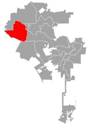
Los Angeles's 3rd City Council district is one of the fifteen districts in the Los Angeles City Council. It is currently represented by Democrat Bob Blumenfield since 2013 after winning an election to succeed Dennis Zine, who termed out and ran for City Controller that year.
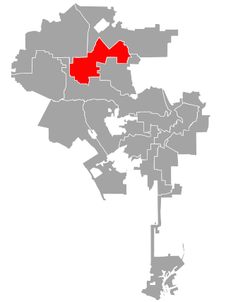
<span class="mw-page-title-main">Los Angeles's 6th City Council district</span> American legislative district

Los Angeles's 6th City Council district is one of the fifteen districts in the Los Angeles City Council. It is currently represented by Imelda Padilla.

<span class="mw-page-title-main">Port Ballona, California</span> 19th century planned harbor of Santa Monica Bay

Port Ballona is an archaic place name for an area near the center of Santa Monica Bay in coastal Los Angeles County, where Playa Del Rey and Del Rey Lagoon are located today. Port Ballona was a planned harbor and town site from circa 1859 to 1903. The name comes from the Rancho La Ballona Mexican land grant.

<span class="mw-page-title-main">Venice–Inglewood Line</span> Historic rail route in California

The Venice–Inglewood Line is a former Pacific Electric interurban railway line in Los Angeles County, California. Service was very sparse, providing a suburban route between Venice and Inglewood.

<span class="mw-page-title-main">Redondo Beach via Playa del Rey Line</span> Historic streetcar line in California

The Redondo Beach via Playa del Rey was an interurban railway route of the Pacific Electric. It operated between the Hill Street Terminal and Cliffton, south of Redondo Beach, through the company's Western Division.

<span class="mw-page-title-main">Culver Boulevard</span> Thoroughfare in Los Angeles, California

Culver Boulevard is an east-west thoroughfare in the Westside region of Los Angeles County, California, connecting Venice Boulevard to the coast roads.

References

  1. "First Map Showing City Council's Districts," Los Angeles Times, January 16, 1925, page 1
  2. "Here Are the Hundred and Twelve Aspirants for the City's Fifteen Councilmanic Seats," Los Angeles Times, May 3, 1925, page 7
  3. Hernández, Caitlin (November 18, 2022). "LA City Council In 2023: Your Guide To Who's Who (And What They Do)". LAist .
  4. "To the Citizens of Los Angeles," Los Angeles Times, February 14, 1926, page B-5
  5. Bing location for district office
  6. "Council Areas' Lines Changed," Los Angeles Times, December 29, 1928, page A-1
  7. "District Lines Get Approval," Los Angeles Times, December 24, 1932, page 2
  8. "City Reapportionment Measure Gets Approval," Los Angeles Times, January 19, 1933 With map of all districts.
  9. "New Council Zones Defined," Los Angeles Times, January 7, 1937, page A-18
  10. "Proposed New Alignment for City Voting Precincts" (with map), Los Angeles Times, November 30, 1940, page A-3
  11. "Civil Defense Post Resigned by Rundberg, Los Angeles Times, April 21, 1957, page A-11]
  12. "Mrs. Wyman Given Edge in 5th Council District," Los Angeles Times, March 27, 1957, page 18
  13. "Council OKs Changes in Its Districts," Los Angeles Times, November 1, 1960, page B-1
  14. Los Angeles Public Library reference file on Marvin Braude
  15. Nancy Hill-Holtzman, "Braude's Legacy Colors Race to Succeed Him," Los Angeles Times, February 9, 1997
  16. "Breedlove Dies Suddenly," Los Angeles Times, April 27, 1934, page A-1
  17. "M'Alister Voted Seat." Los Angeles Times, May 9, 1944, page A-1
  18. "Harby Found Guilty of City Car Misuse," Los Angeles Times, January 9, 1942, page 1
  19. "Stannard Wins Council Seat," Los Angeles Times, May 19, 1942