Related Research Articles

Upper Marlboro, officially the Town of Upper Marlboro, is the county seat of Prince George's County, Maryland, United States. As of the 2020 census, the population within the town limits was 652, although Greater Upper Marlboro, which covers a large area outside the town limits, is many times larger.

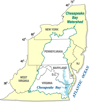
The Patuxent River is a tributary of the Chesapeake Bay in the state of Maryland. There are three main river drainages for central Maryland: the Potomac River to the west passing through Washington, D.C., the Patapsco River to the northeast passing through Baltimore, and the Patuxent River between the two. The 908-square-mile (2,352 km2) Patuxent watershed had a rapidly growing population of 590,769 in 2000. It is the largest and longest river entirely within Maryland, and its watershed is the largest completely within the state.

The Don River is a watercourse in southern Ontario that empties into Lake Ontario, at Toronto Harbour. Its mouth was just east of the street grid of the town of York, Upper Canada, the municipality that evolved into Toronto, Ontario. The Don is one of the major watercourses draining Toronto that have headwaters in the Oak Ridges Moraine.

The Anacostia River is a river in the Mid Atlantic region of the United States. It flows from Prince George's County in Maryland into Washington, D.C., where it joins with the Washington Channel and ultimately empties into the Potomac River at Buzzard Point. It is about 8.7 miles (14.0 km) long. The name "Anacostia" derives from the area's early history as Nacotchtank, a settlement of Necostan or Anacostan Native Americans on the banks of the Anacostia River.

Rock Creek is a tributary of the Potomac River, in the United States, that empties into the Atlantic Ocean via the Chesapeake Bay. The 32.6-mile (52.5 km) creek drains about 76.5 square miles (198 km2). Its final quarter-mile is affected by tides.

The Jug Bay Wetlands Sanctuary is located along the tidal Patuxent River in southern Maryland, United States. It was established in 1985 and is operated by the Anne Arundel County Department of Recreation and Parks. It includes more than 1,700 acres (6.9 km2) of tidal freshwater wetlands, forests, meadows and fields. The wetlands, with large stands of aquatic plants including wild rice, are home to many birds, fish, reptiles, amphibians, and mammals. Miles of trails and boardwalks traverse a variety of habitats and provide glimpses into the rich history of the region. Notably, archaeologists have uncovered evidence of a large Native American settlement at Jug Bay which spanned 2 miles along the Patuxent, with the oldest arrowhead-like artifact dated between 8,000 to 8,900 years old.
The South River is a 10-mile-long (16 km) tributary of the Chesapeake Bay in Anne Arundel County, Maryland in the United States. It lies south of the Severn River, east of the Patuxent River, and north of the West River and Rhode River, and drains to the Chesapeake Bay.
The Chesapeake Bay Program is the regional partnership that directs and conducts the restoration of the Chesapeake Bay in the United States. As a partnership, the Chesapeake Bay Program brings together members of various state, federal, academic and local watershed organizations to build and adopt policies that support Chesapeake Bay restoration. By combining the resources and unique strengths of each individual organization, the Chesapeake Bay Program is able to follow a unified plan for restoration. The program office is located in Annapolis, Maryland.
Queen Anne in Prince George's County, Maryland, United States, is a former port on the Patuxent River. It was delineated as a CDP for the 2010 census, at which time it had a population of 1,280. Per the 2020 census, the population was 1,405.

Little Falls Branch, a 3.8-mile-long (6.1 km) tributary stream of the Potomac River, is located in Montgomery County, Maryland. In the 19th century, the stream was also called Powder Mill Branch. It drains portions of Bethesda, Somerset, Friendship Heights, and Washington, D.C., flows under the Chesapeake and Ohio Canal (C&O), and empties into the Potomac at Little Falls rapids, which marks the upper end of the tidal Potomac.

Paint Branch is a 17.0-mile-long (27.4 km) tributary stream of the Anacostia River that flows Southeastwards through Montgomery County and Prince George's County, Maryland. Specifically, its primary tributary is of the Northeast Branch, which flows to the Anacostia River, Potomac River and the Chesapeake Bay. The beginning elevation of the stream is 480 feet above sea level and it subsequently drops to 30 feet when its flows meet the Indian Creek in College Park, Maryland.
Watts Branch is a tributary stream of the Potomac River in Montgomery County, Maryland.
Hawlings River is a 12.9-mile-long (20.8 km) tributary of the Patuxent River in Montgomery County, Maryland. The watershed covers an area of about 28 square miles (73 km2). The waterway was originally called Holland's River. The headwaters of the river originate in the area north of Laytonsville, and the river flows southeast, entering the Patuxent about 1.5 miles (2.4 km) below the Triadelphia Reservoir. Portions of Hawlings River flow through Rachel Carson Conservation Park and Hawlings River Stream Valley Park. Tributaries of the Hawlings River include Mount Zion Tributary, Reddy Branch, Olney Mill Tributary, Gregg Tributary, and James Creek. The river and its tributaries total about 98 miles (158 km) of streams.
The Little Magothy River runs 2.5 miles (4.0 km) through Anne Arundel County in the U.S. state of Maryland. It is located southeast of the Magothy River, just outside its mouth and north of the Severn River.

Northwest Branch Anacostia River is a 21.5-mile-long (34.6 km) free-flowing stream in Montgomery County and Prince George's County, Maryland. It is a tributary of the Anacostia River, which flows to the Potomac River and the Chesapeake Bay.
Northeast Branch Anacostia River is a 3.2-mile-long (5.1 km) free-flowing stream in Prince George's County, Maryland. It is a tributary of the Anacostia River, which flows to the Potomac River and the Chesapeake Bay.

Allen Pond Park is an 85-acre (340,000 m2) multi-use park, located in and managed by the City of Bowie in Prince George's County, Maryland. The park includes an ice arena, amphitheater, boat rentals, skate park, 10-acre (40,000 m2) stocked pond, six lighted ballfields, picnic areas and pavilions, walking and biking trails, a lighted basketball court, fitness station and several playground areas. It is also the home of Opportunity Park, which offers 100% accessible experiences at its tot lot, school-aged playground, fitness cluster and fishing. The park has a 39% total wood coverage, with the pond occupying 12% of the park. The parking lot that services the park can be accessed from 3404 Mitchellville Road, across from the Mitchellville Road Soccer Fields, and from the main 3330 Northview Drive entrance.
The Middle Patuxent Environmental Area (MPEA) is a 1,021-acre (4.13 km2) wildlife area in Clarksville, Maryland and operated by the Howard County Department of Recreation and Parks. It is located next to the River Hill village in the town of Columbia, Maryland, in the United States. The MPEA was created in 1996 for educational, research, and recreational purposes.
Collington Branch is a stream that flows into the Western Branch of the Patuxent River in Prince George's County, Maryland.
The Green Branch of the Patuxent River in Prince George's County, Maryland is part of the Upper Patuxent Watershed. The stream passes centrally through the Governor Bridge Natural Area / Patuxent River Park and joins the Patuxent, just south of Governor's Bridge.
References
- ↑ "City of Bowie Environmental Infrastructure Action Strategy Plan Staff Findings and Recommendations By Sub-watershed". City of Bowie. p. ii. Retrieved 21 January 2015.
- ↑ "Upper Patuxent River Watershed Restoration Action Strategy" (PDF). Watershed Restoration Action Strategies. Maryland Department of Natural Resources: 27. Retrieved 21 January 2015.
- 1 2 "City of Bowie Environmental Infrastructure Action Strategy Plan Staff Findings and Recommendations By Sub-watershed". City of Bowie. p. 30. Retrieved 21 January 2015.
38°55′26.9″N76°42′34.5″W / 38.924139°N 76.709583°W