
The City of Shoalhaven is a local government area in the south-eastern coastal region of New South Wales, Australia. The area is about 200 kilometres (120 mi) south of Sydney. The Princes Highway passes through the area, and the South Coast railway line traverses the northern section, terminating at Bomaderry. At the 2021 census, the population was 108,531.
Berry is a small Australian village in the Shoalhaven region of the New South Wales South Coast, located 143 km (89 mi) south of the state capital, Sydney. It has many historical buildings which are listed on the New South Wales Heritage Register. Berry attracts many tourists who come to enjoy the diversity of landscapes, including coastal beaches, rich dairy farming, and forested mountains. The village hosts a local Produce Market which is held twice each month on the second Saturday and fourth Sunday. Together with Kiama 23 km (14 mi) to the north, Berry acts as a gateway through to other towns and villages along the South Coast of NSW via the Princes Highway and the South Coast railway line. Major highway building projects in and around Berry have now bypassed the village, creating uninterrupted motorway conditions for coastal travel south to Nowra and the South Coast and north to Wollongong and Sydney. This has resulted in the removal of all but local and visitor traffic within the village. Planning is underway to create a pedestrian-friendly precinct in and around Queens Street.

The Illawarra is a coastal region in the Australian state of New South Wales, nestled between the mountains and the sea. It is situated immediately south of Sydney and north of the South Coast region. It encompasses the two cities of Wollongong, Shellharbour and the coastal town of Kiama. Wollongong is the largest city of the Illawarra with a population of 240,000, then Shellharbour with a population of 70,000 and Kiama with a population of 10,000. These three cities have their own suburbs. Wollongong stretches from Otford in the north to Windang in the south, with Maddens Plains and Cordeaux in the west.

Gerringong is a town located about ten minutes drive south of Kiama, and about twenty minutes north of Nowra in the Illawarra region of New South Wales, Australia in the Municipality of Kiama. At the 2016 census, Gerringong had a population of 3,966. One theory says that the name derives from an Aboriginal word meaning "fearful place".
Gareth James Ward is a suspended Australian politician who served as the New South Wales Minister for Families, Communities and Disability Services in the second Berejiklian ministry from 2019 to 2021. Ward is a member of the New South Wales Legislative Assembly and has represented the seat of Kiama since 2011. He was suspended from NSW parliament after being charged with sexual intercourse without consent, and indecent assault. He is currently awaiting trial, and continuing to act as the MP for Kiama on full pay.

Gerringong is a single-platform intercity train station located in Gerringong, New South Wales, Australia, on the South Coast railway line. The station serves NSW TrainLink diesel multiple unit trains travelling south to Bomaderry and north to Kiama. Early morning and late night services to the station are provided by train replacement bus services. In the past, the station precinct also catered to freight trains carrying dairy products.

Kiama is an electoral district of the Legislative Assembly in the Australian state of New South Wales. It is currently represented by Gareth Ward. Originally elected as a member of the Liberal Party, Ward stood down from the party in May 2021 following allegations of sexual misconduct.

South Coast Group 7 Rugby League is the divisional boundary drawn from the Southern Illawarra and South Coast regions of New South Wales, Australia and is governed by the NSWCRL. The main semi-professional competition,, comprises ten (10) teams from across the region. Group 7 Rugby League also administers reserve grade, third grade, and under-18s competitions, Ladies League Tag, as well as looking over many junior competitions.

The Municipality of Kiama is a local government area in the Illawarra region of New South Wales, Australia. The area is situated south of Shellharbour and the City of Wollongong and is located adjacent to the Pacific Ocean, the Princes Highway and the South Coast railway line.
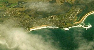
Minnamurra is a village in the Illawarra region of New South Wales, Australia, in the Municipality of Kiama. It has a station on City Rail South Coast line. The Minnamurra River flows into the ocean at Minnamurra. There is a sandy beach and a sand spit at the river mouth.
The Municipality of Ulladulla was a municipality of New South Wales that existed from 1874 to 1948. It was divided into the three wards of Ulladulla, Milton and Narrawallee.

Willow Vale is a small town in New South Wales, Australia, in the Municipality of Kiama. It is made up of residences, dairy farms, and more recently the Crooked River Winery.

Foxground is a locality in the Municipality of Kiama, in the Illawarra region of New South Wales, Australia. It is located two kilometres from the Princes Highway, 10 kilometres south west of Kiama. Broughton Creek flows through the valley.

Broughton Village is a locality on the border of the Kiama and Shoalhaven local government areas in New South Wales, Australia. It lies on the Princes Highway about 18 southwest of Kiama and 39 km north of Nowra and on Broughton Creek. At the 2016 census, it had a population of 86. Broughton Village is to not to be confused with Broughton, a locality that lies to its immediate southwest or Broughton Vale, which lies to its immediate northwest.

Broughton Vale is a locality in the City of Shoalhaven in New South Wales, Australia. It lies north of the Princes Highway at Berry between Nowra and Gerringong and on Broughton Mill creek. At the 2016 census, it had a population of 165. Broughton Vale is to not to be confused with Broughton Village or Broughton, which both lie to its immediate east.
Clyde Shire was a local government area in the South Coast region of New South Wales, Australia.
Cambewarra Shire was a local government area in the South Coast region of New South Wales, Australia.
The Municipality of Nowra was a municipality of New South Wales that existed from 1871 to 1948.