Natural Chimneys

Last updated
Natural Chimneys
Natural Chimneys Cyclopean Towers.jpg
USA Virginia location map.svg
Red pog.svg
Location of Natural Chimneys within Virginia
Usa edcp location map.svg
Red pog.svg
Natural Chimneys (the United States)
Type Regional park
Location Mt. Solon
Augusta County, Virginia
Coordinates 38°21′28″N79°04′34″W / 38.3579°N 79.0760°W / 38.3579; -79.0760
Operated by Augusta County Parks and Recreation
OpenAll year
Camp sites145

Natural Chimneys, known as the Cyclopean Towers in the 19th century, is a natural rock structure located near Mt. Solon in Augusta County, Virginia in the United States, in the Shenandoah Valley. The formation is a central feature of a regional park owned and operated by Augusta County.

Contents

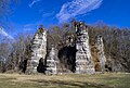
The formation includes seven rock "chimneys" that range in height from 65 to 120 feet (20 to 37 m) above ground level. The chimneys are formed from limestone that began to accumulate and harden into stone about 500 million years ago in the Paleozoic Era, when the region was underwater. Over time, enormous upward pressures of magma and widespread geologic upheaval, which created the Appalachian Mountains, combined with erosive forces of water and destroyed weaker layers of stone. Eventually, this created the rock chimneys which can be seen today. [1]

The park, located along the North River, has a 145-site campground with a pool, playground, and hiking trails. The park also hosts one of the largest jousting tournaments in the eastern United States. The tournament is held on the third Saturday of August, and has taken place annually since 1821. The tournament includes the historical sport of "running at the ring". [2] Augusta County owns the property and maintains the facility.

Related Research Articles

<span class="mw-page-title-main">Stone Mountain State Park</span>

Stone Mountain State Park is a 14,353-acre (58.08 km2) North Carolina state park in Alleghany County and Wilkes County, North Carolina.

<span class="mw-page-title-main">City of Rocks National Reserve</span> Protected natural area in Idaho, United States

The City of Rocks National Reserve, also known as the Silent City of Rocks, is a United States National Reserve and state park in south-central Idaho, approximately 2 miles (3.2 km) north of the border with Utah. It is widely known for its enormous granite rock formations and excellent rock climbing.

<span class="mw-page-title-main">Franconia Notch State Park</span> State park in New Hampshire, United States

Franconia Notch State Park is a public recreation area and nature preserve that straddles eight miles (13 km) of Interstate 93 as it passes through Franconia Notch, a mountain pass between the Kinsman Range and Franconia Range in the White Mountains of northern New Hampshire, United States. The northern part of the park, including Cannon Mountain and Echo and Profile lakes, is in the town of Franconia, and the southern part, including Lonesome Lake and the Flume, is in Lincoln. Attractions in the state park include the Flume Gorge and visitor center, the Old Man of the Mountain historical site, fishing in Echo Lake and Profile Lake, and miles of hiking, biking and ski trails.

<span class="mw-page-title-main">Robert H. Treman State Park</span> State park in New York, United States

Robert H. Treman State Park is a 1,110-acre (4.5 km2) state park located in Tompkins County, in the Finger Lakes region of New York in the United States. The park is situated in the towns of Ithaca, Enfield and Newfield.

<span class="mw-page-title-main">Valley of Fire State Park</span> State park in Nevada, United States

Valley of Fire State Park is a public recreation and nature preservation area covering nearly 46,000 acres (19,000 ha) located 16 miles (26 km) south of Overton, Nevada. The state park derives its name from red sandstone formations, the Aztec Sandstone, which formed from shifting sand dunes 150 million years ago. These features, which are the centerpiece of the park's attractions, often appear to be on fire when reflecting the sun's rays. It is Nevada's oldest state park, as commemorated with Nevada Historical Marker #150. It was designated as a National Natural Landmark in 1968.

<span class="mw-page-title-main">Arabia Mountain</span> Mountain in Georgia, United States of America

Arabia Mountain, a part of Arabia Mountain National Heritage Area, is the northern of two peaks in the Davidson-Arabia Mountain Nature Preserve, in DeKalb County, Georgia, United States. A low saddle separates it from Bradley Mountain, several hundred feet to its south. The two form a monadnock. The peak is 955 feet (290 m) above sea level, rising 172 feet (52 m) above Arabia Lake reservoir. Bradley Mountain is closer to the visitor trails than Arabia Mountain and is often misidentified by visitors as Arabia Mountain.

<span class="mw-page-title-main">Lake Martin</span> Reservoir in Alabama, United States

Lake Martin is located in Tallapoosa, Elmore and Coosa counties in Alabama. It is a 39,000-acre (178 km2) reservoir with over 750 miles (1,200 km) of wooded shoreline. Lake Martin is a reservoir, enlarged by the construction of Martin Dam on the Tallapoosa River.The Martin Dam powerhouse is used to generate hydroelectric power for the Alabama Power Company. Construction on Martin Dam began in 1923 and was completed in 1926, creating what was, at that time, the largest human-made body of water in the world. Originally known as Cherokee Bluffs for the geological formation upon which it was built, the dam was renamed in 1936 in honor of Thomas Martin, the then-president of Alabama Power Company. Alabama Power and Russell Lands own some of the shoreline.

Chimney Rock can refer to one of the following sites in the United States and Canada:

<span class="mw-page-title-main">Devil's Lake State Park (Wisconsin)</span> State Park in Sauk County, Wisconsin

Devil's Lake State Park is a state park located in the Baraboo Range in eastern Sauk County, just south of Baraboo, Wisconsin. It is around thirty-five miles northwest of Madison, and is on the western edge of the last ice-sheet deposited during the Wisconsin glaciation. The state park encompasses 9,217 acres (3,730 ha), making it the largest in Wisconsin. The state park is known for its 500-foot-high (150 m) quartzite bluffs along the 360-acre (150 ha) Devil's Lake, which was created by a glacier depositing terminal moraines that plugged the north and south ends of the gap in the bluffs during the last ice age approximately 12,000 years ago. The sand at the bottom of Devil's Lake is thought to be deposited by glaciers.

<span class="mw-page-title-main">Lost Creek Wilderness</span> Protected wilderness area in the U.S. state of Colorado

The Lost Creek Wilderness is a 119,790-acre (485 km2) wilderness area located in central Colorado in Jefferson and Park counties, south of the town of Bailey. The area is situated entirely within the boundaries of the Pike National Forest.

<span class="mw-page-title-main">Interstate Park</span> United States historic place

Interstate Park comprises two adjacent state parks on the Minnesota–Wisconsin border, both named Interstate State Park. They straddle the Dalles of the St. Croix River, a deep basalt gorge with glacial potholes and other rock formations. The Wisconsin park is 1,330 acres (538 ha) and the Minnesota park is 298 acres (121 ha). The towns of Taylors Falls, Minnesota and St. Croix Falls, Wisconsin are adjacent to the park. Interstate Park is within the Saint Croix National Scenic Riverway and the Ice Age National Scientific Reserve. The western terminus of the Ice Age National Scenic Trail is on the Wisconsin side. On the Minnesota side, two areas contain National Park Service rustic style buildings and structures that are listed on the National Register of Historic Places.

<span class="mw-page-title-main">Cape Kiwanda State Natural Area</span> State natural area in Oregon, United States

Cape Kiwanda State Natural Area is a state park in Pacific City, Oregon, United States. Cape Kiwanda is on the Three Capes Scenic Route, which includes Cape Meares and Cape Lookout. Hiking to the top of Cape Kiwanda allows views of Nestucca Bay to the south and Cape Lookout to the north.

<span class="mw-page-title-main">Mississippi National River and Recreation Area</span> National Park Service area in the United States

The Mississippi National River and Recreation Area is a 72-mile (116 km) and 54,000-acre (22,000 ha) protected corridor along the Mississippi River through the Minneapolis–Saint Paul metro in the U.S. state of Minnesota, from the cities of Dayton and Ramsey, to just downstream of Hastings. This stretch of the upper Mississippi River includes natural, historical, recreational, cultural, scenic, scientific, and economic resources of national significance. This area is the only national park site dedicated exclusively to the Mississippi River. The Mississippi National River and Recreation Area is sometimes abbreviated as MNRRA or MISS, the four letter code assigned to the area by the National Park Service. The Mississippi National River and Recreation Area is classified as one of four national rivers in the United States, and despite its name it is technically not one of the 40 national recreation areas.

<span class="mw-page-title-main">Powell Butte</span> Extinct cinder cone butte in Portland, Oregon, U.S.

Powell Butte is an extinct cinder cone butte in Portland, Oregon, United States. It is part of the Boring Lava Field, which includes more than 80 small volcanic edifices and lava flows in the Portland–Vancouver metropolitan area. The region around Powell Butte has a cool climate, and the butte and its surroundings feature meadows, rivers, and mixed forests. Powell Butte hosts the Powell Butte Nature Park, which includes about 612 acres (2.48 km2) of trails for biking, hiking, and horseback riding.

<span class="mw-page-title-main">Mount Solon, Virginia</span> Unincorporated community in Virginia, United States

Mount Solon is an unincorporated community in Augusta County, Virginia, United States, 22 miles (35 km) southwest of Harrisonburg and 20 miles (32 km) north of Staunton. It is part of the Staunton–Waynesboro Micropolitan Statistical Area.

<span class="mw-page-title-main">Hazen's Notch</span>

Hazen's Notch is a mountain pass in Westfield, in the northern Green Mountains of Vermont. Hazen's Notch was named after Moses Hazen, who in 1779 led the construction of the Bayley Hazen Military Road. The road was planned to extend from Newbury, Vermont, to Saint-Jean-sur-Richelieu, Quebec, not far from Montreal, to facilitate an invasion of Canada during the American Revolutionary War; it had reached this point when construction stopped.

<span class="mw-page-title-main">Erratic Rock State Natural Site</span>

Erratic Rock State Natural Site is a state park in the Willamette Valley of Oregon, United States. Featuring a 40-short-ton (36 t) glacial erratic from the Missoula Floods, the small park sits atop a foothill of the Northern Oregon Coast Range in Yamhill County between Sheridan and McMinnville off Oregon Route 18. The day use only park is owned and maintained by the Oregon Parks and Recreation Department.

<span class="mw-page-title-main">Table Rock State Park (Missouri)</span> State park in southwest Missouri, US

Table Rock State Park is a public recreation area in the U.S. state of Missouri consisting of 356 acres (144 ha) located in Taney County and Stone County on Table Rock Lake along the southern side of the city of Branson. The state park's facilities include a marina, campgrounds, and trails for hiking and bicycling.

Humpback Rocks is a massive greenstone outcropping near the peak of Humpback Mountain in the Blue Ridge Mountains of Augusta County and Nelson County, Virginia, United States, with a summit elevation of 3,080 feet (940 m). The rock formation is so named for the visual effect of a "hump" it creates on the western face of the mountain.

<span class="mw-page-title-main">Minisink</span>

The Minisink or Minisink Valley is a loosely defined geographic region of the Upper Delaware River valley in northwestern New Jersey, northeastern Pennsylvania and New York.

References

  1. "Geological & Historical Significance". Natural Chimneys. Augusta County Parks and Recreation. Retrieved February 22, 2017.
  2. Information signs at the park