
Madison County is a county in the U.S. state of Nebraska. As of the 2020 United States Census, the population was 35,585. Its county seat is Madison and its largest city is Norfolk. Madison County was likely named for Madison, Wisconsin, which is where many of the county’s residents came from; the city was named for James Madison, fourth President of the United States.
The Point Pleasant Micropolitan Statistical Area, as defined by the United States Census Bureau, is an area consisting of two counties – one in West Virginia and one in Ohio – anchored by the city of Point Pleasant, West Virginia.

The Clarksburg Micropolitan Statistical Area, as defined by the United States Census Bureau, is an area consisting of four counties in North-Central West Virginia, anchored by the city of Clarksburg.

The Hastings Micropolitan Statistical Area, as defined by the United States Census Bureau, is an area consisting of two counties in Nebraska, anchored by the city of Hastings.

The Kearney Micropolitan Statistical Area, as defined by the United States Census Bureau, is an area consisting of two counties in Nebraska, anchored by the city of Kearney.
The Tullahoma–Manchester Micropolitan Statistical Area, as defined by the United States Census Bureau, is an area consisting of two counties in central Tennessee, anchored by the cities of Tullahoma and Manchester.

The Roanoke Rapids, NC Micropolitan Statistical Area (μSA) as defined by the United States Census Bureau, is an area consisting of two counties in North Carolina, anchored by the city of Roanoke Rapids.

The Ardmore Micropolitan Statistical Area, as defined by the United States Census Bureau, is an area consisting of one county in South Central Oklahoma, anchored by the city of Ardmore.

The Burlington, IA−IL Micropolitan Statistical Area, as defined by the United States Census Bureau, is an area consisting of two counties−one in southeast Iowa and the other in West Central Illinois, anchored by the city of Burlington, Iowa.

The Mount Vernon, IL Micropolitan Statistical Area, as defined by the United States Census Bureau, is an area consisting of one county in southern Illinois, anchored by the city of Mount Vernon.

The Jacksonville, IL Micropolitan Statistical Area, as defined by the United States Census Bureau, is an area consisting of two counties in west central Illinois, anchored by the city of Jacksonville.
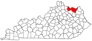
The Maysville Micropolitan Statistical Area (μSA), as defined by the United States Census Bureau, is coterminous with Mason County, Kentucky, whose county seat and largest city is Maysville. As of the 2010 census, the population of Mason County and the current μSA was 17,490, and 2014 Census Bureau estimates place the population at 17,166.
The Fort Madison–Keokuk, IA-IL-MO Micropolitan Statistical Area, as defined by the United States Census Bureau, locally known as the "Tri-State" area, was an area consisting of three counties – one in southeast Iowa, one in northeast Missouri, and one in west central Illinois, anchored by the cities of Fort Madison, Iowa and Keokuk, Iowa. As of the 2010 census, the μSA had a population of 62,105. An estimate by the Census Bureau, as of July 1, 2012, placed the population at 61,477, a decrease of 1.01%. When the 2023 definitions were released this area was dissolved with Lee County, Iowa being included as part of the Burlington–Fort Madison, IA–IL Combined Statistical Area.

The Hannibal Micropolitan Statistical Area, as defined by the United States Census Bureau, is an area consisting of two counties in northeast Missouri, anchored by the city of Hannibal.

The Camden Micropolitan Statistical Area, as defined by the United States Census Bureau, is an area consisting of two counties in the U.S. state of Arkansas, anchored by the city of Camden.

The Emporia Micropolitan Statistical Area, as defined by the United States Census Bureau, is an area consisting of two counties in Kansas, anchored by the city of Emporia.

The Safford Micropolitan Statistical Area, as defined by the United States Census Bureau, is a micropolitan statistical area (μSA) consisting of one county in eastern Arizona, anchored by the city of Safford.

The Waycross Micropolitan Statistical Area (μSA), as defined by the United States Census Bureau, is an area consisting of two counties in Georgia, anchored by the city of Waycross.

The Brainerd Micropolitan Statistical Area, as defined by the United States Census Bureau, is an area consisting of Cass County and Crow Wing County in Northern Minnesota, anchored by the city of Brainerd. As of July 1, 2022 estimate placed the population at 99,222.

The Dickinson Micropolitan Statistical Area, as defined by the United States Census Bureau, is an area consisting of two counties in North Dakota, anchored by the city of Dickinson. As of the 2010 census, the μSA had a population of 24,982.

